[Official] British Isles REVAMP [Quenched]
Moderator: Cartographers

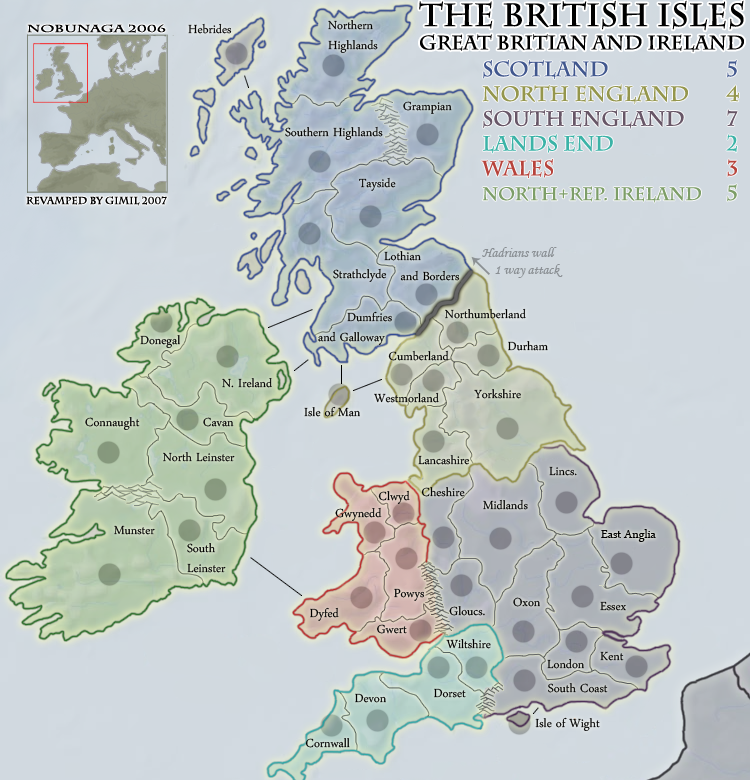
![]() by MrBenn on Mon Dec 10, 2007 9:17 am
by MrBenn on Mon Dec 10, 2007 9:17 am
I think your 'shipping routes' need a little work. Maybe use a dotted or dashed line; and possibly try and make them curved?
I've just noticed that you've got Northern Ireland joined to strathclyde, when the original link is from Donegal.
Otherwise it's looking good!
I've just noticed that you've got Northern Ireland joined to strathclyde, when the original link is from Donegal.
Otherwise it's looking good!
-

 MrBenn
- Posts: 6880
- Joined: Wed Nov 21, 2007 9:32 am
- Location: Off Duty


![]() by MrBenn on Mon Dec 10, 2007 9:26 am
by MrBenn on Mon Dec 10, 2007 9:26 am
Oh, In the title, you've misspelt Britain 
To reflect some of the original features, how about finding an image of a compass?
I was just wondering whether it might be worth swapping some of the bonus area colours around a little to reflect the original? I'm personally not bothered, but some of the purists might appreciate it!
To reflect some of the original features, how about finding an image of a compass?
I was just wondering whether it might be worth swapping some of the bonus area colours around a little to reflect the original? I'm personally not bothered, but some of the purists might appreciate it!
-
MrBenn
- Posts: 6880
- Joined: Wed Nov 21, 2007 9:32 am
- Location: Off Duty
![]() by oaktown on Mon Dec 10, 2007 9:29 am
by oaktown on Mon Dec 10, 2007 9:29 am
My first look at this - already much superior to the original. Apologies if I'm rehashing old concerns...
Lancashire should be bordering clwyd, right? It looks as if there is the tiniest gap between the borders.
You and I know, but will everybody know what "North + Rep Ireland" means?
The text looks awfully small... what will happen to it on a small map?
And you know that "Great Britain" is spelled wrong in your title?

-

oaktown
- Posts: 4451
- Joined: Sun Dec 03, 2006 9:24 pm
- Location: majorcommand


![]() by rebelman on Mon Dec 10, 2007 9:45 am
by rebelman on Mon Dec 10, 2007 9:45 am
Its "Britain" not "Britian" - typo in title
=======================================================
your new title is daft if you don't mind me saying so
=======================================================
the Irish Geography is still very dodgy in places:

hope this helps - look at map above for clarification
Munster - Waterford, Cork, Kerry, Limerick and Tipperary
Connaught - Galway, Mayo, Sligo & Rosscommon (add in Clare here instead of in Munster and make the impassible the river Shannon)
South Leinster - Offaly, Laois, Kildare, Wicklow, Carlow, kilkenny, Wexford
North Leinster - Longford, Westmeath, Meath, Dublin
Border - Louth, Monaghan, Cavan, Leitrim (Leitrim has to be moved out of connaught to keep the gameplay as was)
Donegal - Donegal
Northern Ireland - Tyrone, Derry, Antrim, Down, Armagh and Fermanagh
The above should maintain the original game play while being more accurate geographically.
=======================================================
your new title is daft if you don't mind me saying so
=======================================================
the Irish Geography is still very dodgy in places:
hope this helps - look at map above for clarification
Munster - Waterford, Cork, Kerry, Limerick and Tipperary
Connaught - Galway, Mayo, Sligo & Rosscommon (add in Clare here instead of in Munster and make the impassible the river Shannon)
South Leinster - Offaly, Laois, Kildare, Wicklow, Carlow, kilkenny, Wexford
North Leinster - Longford, Westmeath, Meath, Dublin
Border - Louth, Monaghan, Cavan, Leitrim (Leitrim has to be moved out of connaught to keep the gameplay as was)
Donegal - Donegal
Northern Ireland - Tyrone, Derry, Antrim, Down, Armagh and Fermanagh
The above should maintain the original game play while being more accurate geographically.
Don't now why people on here don't like being cooks, remember under siege: A former SEAL, now cook, is the only person who can stop a gang of terrorists when they sieze control of a US Navy battleship.
-

rebelman
- Posts: 2968
- Joined: Thu Aug 02, 2007 5:24 pm
- Location: People's Republic of Cork


![]() by rebelman on Mon Dec 10, 2007 9:47 am
by rebelman on Mon Dec 10, 2007 9:47 am
wicked wrote:Can ya make the moutains a little bit darker or thicker? I'm afraid they won't show up very well on the small map, which the majority will play.
im hoping those mountains will go and a river will replace them as per my above post
Don't now why people on here don't like being cooks, remember under siege: A former SEAL, now cook, is the only person who can stop a gang of terrorists when they sieze control of a US Navy battleship.
-
rebelman
- Posts: 2968
- Joined: Thu Aug 02, 2007 5:24 pm
- Location: People's Republic of Cork
![]() by rebelman on Mon Dec 10, 2007 9:50 am
by rebelman on Mon Dec 10, 2007 9:50 am
oaktown wrote:You and I know, but will everybody know what "North + Rep Ireland" means?
the name of the island is Ireland so Ireland would be fine in this context and not be the source of any political controversy.
Don't now why people on here don't like being cooks, remember under siege: A former SEAL, now cook, is the only person who can stop a gang of terrorists when they sieze control of a US Navy battleship.
-
rebelman
- Posts: 2968
- Joined: Thu Aug 02, 2007 5:24 pm
- Location: People's Republic of Cork
![]() by lord voldemort on Mon Dec 10, 2007 10:03 am
by lord voldemort on Mon Dec 10, 2007 10:03 am
MrBenn wrote:It should be 'Midlands' or 'The Midlands'
You could use 'Lincs' instead of Lincolnshire
I had a thought about the East Anglia problem, but can't remember what it was... I'll have another think!
In the meantime, what about this as an alternative title?The British Isles:
Great Britain & Ireland
east anglia, thats where harry potter is from...
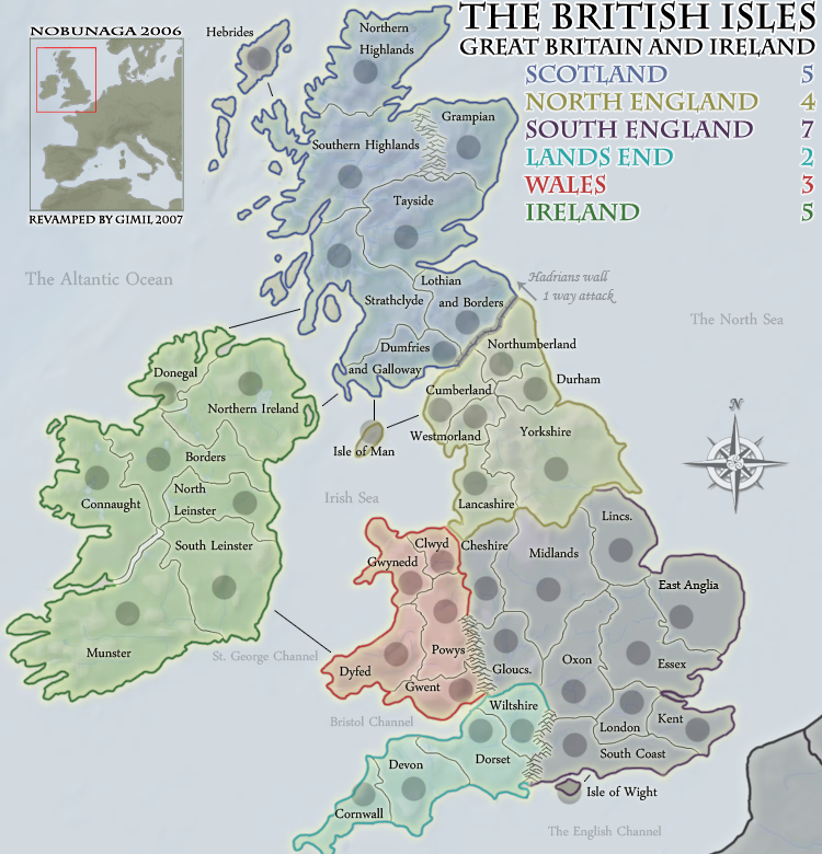
im liking this revamp, not sure bout the wall. i think it could be graphically better

-

lord voldemort
- Posts: 9596
- Joined: Sat Oct 20, 2007 4:39 am
- Location: Launceston, Australia


![]() by MrBenn on Mon Dec 10, 2007 10:23 am
by MrBenn on Mon Dec 10, 2007 10:23 am
lord voldemort wrote:MrBenn wrote:I had a thought about the East Anglia problem, but can't remember what it was... I'll have another think!
east anglia, thats where harry potter is from...
That explains the scar on my forehead, and why it hurts to think about it too much!
-
MrBenn
- Posts: 6880
- Joined: Wed Nov 21, 2007 9:32 am
- Location: Off Duty
![]() by iancanton on Mon Dec 10, 2007 1:46 pm
by iancanton on Mon Dec 10, 2007 1:46 pm
as mentioned before, can we rename “cheshire” as “west midlands”, then expand west midlands to include staffordshire, warwickshire, herefordshire and worcestershire, then redraw the southern england continent to exclude cheshire (which is culturally part of the north of england), then expand “lancashire” to include cheshire? the “west midlands” territory then becomes identical to the government office region of the same name.
a similar renaming can be done for “midland” to “east midlands”, which will include derbyshire, nottinghamshire, leicestershire, rutland and northamptonshire, again following the government office regional boundary (excluding lincolnshire). in this way, the borders have some basis in reality, rather than being drawn at random.
http://www.statistics.gov.uk/geography/gor.asp
ian.
-

iancanton
- Foundry Foreman

- Posts: 2447
- Joined: Fri Jun 01, 2007 5:40 am
- Location: europe


![]() by pepperonibread on Mon Dec 10, 2007 3:57 pm
by pepperonibread on Mon Dec 10, 2007 3:57 pm
The mountains look good now, except for on the Connaught-Munster border in Ireland. I think it's because they aren't vertical, so maybe scrunching them together a bit would help.

-

pepperonibread
- Posts: 954
- Joined: Sun Jan 28, 2007 4:33 pm
- Location: The Former Confederacy


![]() by I GOT SERVED on Tue Dec 11, 2007 1:45 pm
by I GOT SERVED on Tue Dec 11, 2007 1:45 pm
gimil wrote:TODO
-Ireland unpassable
-Fix lands end unpassable
I'd still like to see a wall graphic for Hadrians wall.

Highest score: 2512
Highest rank: 424
-

I GOT SERVED
- Posts: 1532
- Joined: Fri Jan 26, 2007 9:42 pm
- Location: Good 'ol New England


![]() by Balsiefen on Tue Dec 11, 2007 1:53 pm
by Balsiefen on Tue Dec 11, 2007 1:53 pm
I GOT SERVED wrote:gimil wrote:TODO
-Ireland unpassable
-Fix lands end unpassable
I'd still like to see a wall graphic for Hadrians wall.
Agreed. Does anyone else think the colours look a little washed out as well?
-

Balsiefen
- Posts: 2299
- Joined: Wed Aug 30, 2006 6:15 am
- Location: The Ford of the Aldar in the East of the Kingdom of Lindissi


![]() by MrBenn on Tue Dec 11, 2007 2:37 pm
by MrBenn on Tue Dec 11, 2007 2:37 pm
It looks like you're getting there!
There's plenty of room in Northern Ireland to write 'Northern' - and the abbreviation isn't used elsewhere, so if possible, I'd try and get it on there in full.
I still think the shipping/ferry routes need a bit of work (I'd recommend making them dashed, and possibly slightly curved)
You've got the Ireland impassable on your 'To-Do' list - don't forget to expand the Wiltshire/South Coast one... and do consider using the New Forest!
I think it needs something in the ocean at the bottom-right... perhaps a compass image or something?
-
MrBenn
- Posts: 6880
- Joined: Wed Nov 21, 2007 9:32 am
- Location: Off Duty
![]() by gimil on Tue Dec 11, 2007 2:40 pm
by gimil on Tue Dec 11, 2007 2:40 pm
TODO
-Ireland unpassable
-Fix lands end unpassable
-Attempt wall graphics for hadrians
-typo on borders
-Northern ireland terr name
-Tweek sea routes
-Possible compass
-Ireland unpassable
-Fix lands end unpassable
-Attempt wall graphics for hadrians
-typo on borders
-Northern ireland terr name
-Tweek sea routes
-Possible compass
What do you know about map making, bitch?
Top Score:2403
natty_dread wrote:I was wrong
Top Score:2403
-

gimil
- Posts: 8599
- Joined: Sat Mar 03, 2007 12:42 pm
- Location: United Kingdom (Scotland)


![]() by I GOT SERVED on Tue Dec 11, 2007 4:15 pm
by I GOT SERVED on Tue Dec 11, 2007 4:15 pm
I appreciate the attempt on the wall graphic, but I don't really like it. Maybe have it look more like the old-school red birck style, or something like that.
Highest score: 2512
Highest rank: 424
-
I GOT SERVED
- Posts: 1532
- Joined: Fri Jan 26, 2007 9:42 pm
- Location: Good 'ol New England
Who is online
Users browsing this forum: No registered users
|
|||||||
| Conquer Club is not associated with RISK online in any way. Copyright © 2006-2025 by Big Wham LLC | |||||||