Nice update gimil.
I was just wondering about some things [I have not read through the thread, yet]:
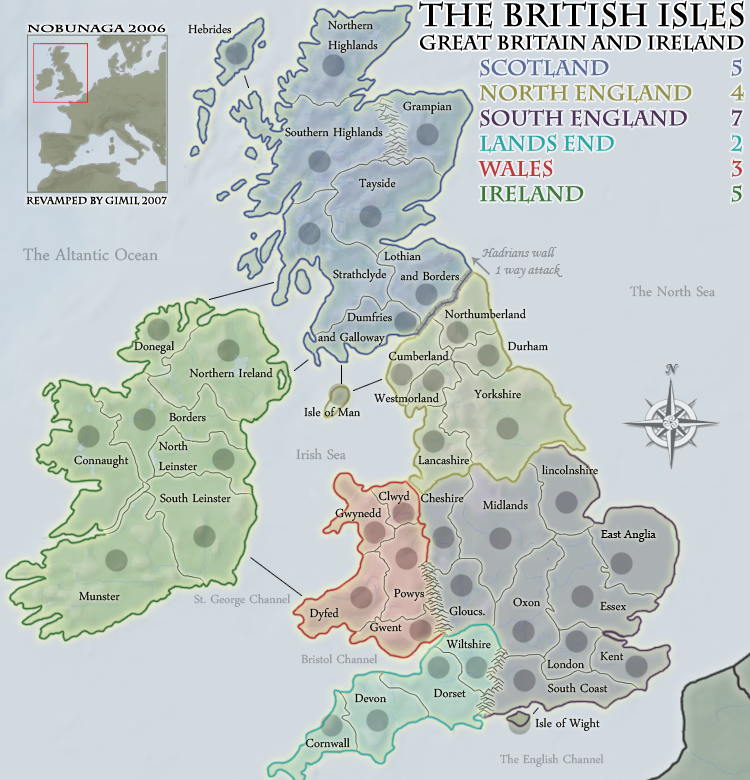
1) The non-playable text ["The Atlantic Ocean," etc.] seems a bit light?
2) Both isles are smaller than their army circles. Isle of Man looks very much like an off kilter attempt to draw Saturn. Isle of Wight looks like you've put a blanket [or graduation cap] on top of a ball. I like Isle of Wight. Not so much for Isle of Man - whilst changing the shape drastically would make it totally geographically incorrect, a small alteration should be acceptable [especially with the room available].
3) Hebrides [part of Scotland] seems to have a different background than the rest of the continent. It's more like a cross between the backgrounds of North England and South England.
4) Lincs - I assume this is supposed to be Lincolnshire? I just noticed that you also have Gloucs abbreviated as well. This is a tough one - but you need a standard that you apply to ALL the terrs. If the length or number of syllables is greater than X, it gets abbreviated - otherwise it doesn't. OR the delimiter could be whether or not all the letters fit IN the territory - in which case Northumberland would need to be abbreviated ("N. Umber."?). ... Lincolnshire isn't really affected by anything other than the compass. You could move the terr name down a pixel or two and move the compass up a pixel or two. I can definitely see a need to abbreviate Gloucs.
5) The background color of the non-playable land [France] is too close to that of Southern England. No one SHOULD be confused by this, but it's possible. Maybe use the same color that you use in the inset? That sort of brownish thing.
Having written the above comments, I'll now go back and see if they were addressed earlier in the thread (I'm up to page 6).
-- Aerial Attack
[Official] British Isles REVAMP [Quenched]
Moderator: Cartographers
![]() by Aerial Attack on Tue Dec 11, 2007 6:06 pm
by Aerial Attack on Tue Dec 11, 2007 6:06 pm
-

 Aerial Attack
- Posts: 1132
- Joined: Mon Jun 04, 2007 7:59 pm
- Location: Generation One: The Clan


![]() by rebelman on Tue Dec 11, 2007 6:39 pm
by rebelman on Tue Dec 11, 2007 6:39 pm
ireland is looking sweet now gimil, i would consider moving the army circle in donegal though, if you move the writing up a tiny bit you can move the circle properly onto the land
Don't now why people on here don't like being cooks, remember under siege: A former SEAL, now cook, is the only person who can stop a gang of terrorists when they sieze control of a US Navy battleship.
-

rebelman
- Posts: 2968
- Joined: Thu Aug 02, 2007 5:24 pm
- Location: People's Republic of Cork


![]() by gimil on Tue Dec 11, 2007 6:53 pm
by gimil on Tue Dec 11, 2007 6:53 pm
Aerial Attack wrote:Nice update gimil.
I was just wondering about some things [I have not read through the thread, yet]:
1) The non-playable text ["The Atlantic Ocean," etc.] seems a bit light?
This is to help the hadrians 1 way rule stik out, but i suppose they could be a little darker.
2) Both isles are smaller than their army circles. Isle of Man looks very much like an off kilter attempt to draw Saturn. Isle of Wight looks like you've put a blanket [or graduation cap] on top of a ball. I like Isle of Wight. Not so much for Isle of Man - whilst changing the shape drastically would make it totally geographically incorrect, a small alteration should be acceptable [especially with the room available].
I dont think youve worded this to welL. would you like hte armies circles off the islands? and would you like a slight alternation to the shape of the isle of man?
3) Hebrides [part of Scotland] seems to have a different background than the rest of the continent. It's more like a cross between the backgrounds of North England and South England.
I went back and checked it, it was off. purple rather than blue.
4) Lincs - I assume this is supposed to be Lincolnshire? I just noticed that you also have Gloucs abbreviated as well. This is a tough one - but you need a standard that you apply to ALL the terrs. If the length or number of syllables is greater than X, it gets abbreviated - otherwise it doesn't. OR the delimiter could be whether or not all the letters fit IN the territory - in which case Northumberland would need to be abbreviated ("N. Umber."?). ... Lincolnshire isn't really affected by anything other than the compass. You could move the terr name down a pixel or two and move the compass up a pixel or two. I can definitely see a need to abbreviate Gloucs.
I think ill go back to just having Gloucs abbreviated.
5) The background color of the non-playable land [France] is too close to that of Southern England. No one SHOULD be confused by this, but it's possible. Maybe use the same color that you use in the inset? That sort of brownish thing.
Fixed
Having written the above comments, I'll now go back and see if they were addressed earlier in the thread (I'm up to page 6).
-- Aerial Attack
What do you know about map making, bitch?
Top Score:2403
natty_dread wrote:I was wrong
Top Score:2403
-

gimil
- Posts: 8599
- Joined: Sat Mar 03, 2007 12:42 pm
- Location: United Kingdom (Scotland)


![]() by gimil on Tue Dec 11, 2007 6:53 pm
by gimil on Tue Dec 11, 2007 6:53 pm
rebelman wrote:ireland is looking sweet now gimil, i would consider moving the army circle in donegal though, if you move the writing up a tiny bit you can move the circle properly onto the land
done jsut for you rebelman
What do you know about map making, bitch?
Top Score:2403
natty_dread wrote:I was wrong
Top Score:2403
-
gimil
- Posts: 8599
- Joined: Sat Mar 03, 2007 12:42 pm
- Location: United Kingdom (Scotland)
![]() by gimil on Tue Dec 11, 2007 7:04 pm
by gimil on Tue Dec 11, 2007 7:04 pm
MrBenn wrote:Nice update gimil... I like the ocean names - nice touch!
I'm not too sure if it's just my screen, but it looks like a tiny bit of Cornwall has been cropped off the image... is that just me??
yes it has, so that the map isnt any bigger than it needs to be
What do you know about map making, bitch?
Top Score:2403
natty_dread wrote:I was wrong
Top Score:2403
-
gimil
- Posts: 8599
- Joined: Sat Mar 03, 2007 12:42 pm
- Location: United Kingdom (Scotland)

![]() by MrBenn on Tue Dec 11, 2007 7:15 pm
by MrBenn on Tue Dec 11, 2007 7:15 pm
Hmm... might be worth just 'fudging' the Cornwall boundary a fraction; just to keep the whole boundary on the map!
I forgot to mention earlier that I like the compass!
Maybe you could make the ocean names italic, and un-italicise the Hadrian's Wall rule? That might work too?
Oh, and you've misspelt Atlantic...

I forgot to mention earlier that I like the compass!
Aerial Attack wrote:
Nice update gimil.
I was just wondering about some things [I have not read through the thread, yet]:
1) The non-playable text ["The Atlantic Ocean," etc.] seems a bit light?
This is to help the hadrians 1 way rule stik out, but i suppose they could be a little darker.
Maybe you could make the ocean names italic, and un-italicise the Hadrian's Wall rule? That might work too?
Oh, and you've misspelt Atlantic...
-

MrBenn
- Posts: 6880
- Joined: Wed Nov 21, 2007 9:32 am
- Location: Off Duty


![]() by gimil on Tue Dec 11, 2007 7:43 pm
by gimil on Tue Dec 11, 2007 7:43 pm
MrBenn wrote:Hmm... might be worth just 'fudging' the Cornwall boundary a fraction; just to keep the whole boundary on the map!
I forgot to mention earlier that I like the compass!Aerial Attack wrote:
Nice update gimil.
I was just wondering about some things [I have not read through the thread, yet]:
1) The non-playable text ["The Atlantic Ocean," etc.] seems a bit light?
This is to help the hadrians 1 way rule stik out, but i suppose they could be a little darker.
Maybe you could make the ocean names italic, and un-italicise the Hadrian's Wall rule? That might work too?
Oh, and you've misspelt Atlantic...
hadrians wall text isnt in italics, its a differednt font.
Fixed atlantic

What do you know about map making, bitch?
Top Score:2403
natty_dread wrote:I was wrong
Top Score:2403
-
gimil
- Posts: 8599
- Joined: Sat Mar 03, 2007 12:42 pm
- Location: United Kingdom (Scotland)
![]() by Risktaker17 on Tue Dec 11, 2007 7:45 pm
by Risktaker17 on Tue Dec 11, 2007 7:45 pm
the little Europe map is very unnecessary.
Highest place: 40 1/17/08
Highest point total: 2773 1/17/08
Top Poster Position: 97th
Highest point total: 2773 1/17/08
Top Poster Position: 97th
-

Risktaker17
- Posts: 1495
- Joined: Sun Apr 01, 2007 8:09 am


![]() by gimil on Tue Dec 11, 2007 7:46 pm
by gimil on Tue Dec 11, 2007 7:46 pm
Risktaker17 wrote:the little Europe map is very unnecessary.
yes but its decoration, to cover up unused space.
What do you know about map making, bitch?
Top Score:2403
natty_dread wrote:I was wrong
Top Score:2403
-
gimil
- Posts: 8599
- Joined: Sat Mar 03, 2007 12:42 pm
- Location: United Kingdom (Scotland)
![]() by gimil on Tue Dec 11, 2007 11:19 pm
by gimil on Tue Dec 11, 2007 11:19 pm
wicked wrote:Guys, can you come up with a different NAME for Dummies & Galloway and Loathers & Borders?
no that is there names, thst has always been there names in real life
and there is no substitute
What do you know about map making, bitch?
Top Score:2403
natty_dread wrote:I was wrong
Top Score:2403
-
gimil
- Posts: 8599
- Joined: Sat Mar 03, 2007 12:42 pm
- Location: United Kingdom (Scotland)
![]() by WidowMakers on Wed Dec 12, 2007 12:10 am
by WidowMakers on Wed Dec 12, 2007 12:10 am
If they need to be that name type it like this:wicked wrote:Guys, can you come up with a different NAME for Dummies & Galloway and Loathers & Borders?
Dummies
...and
Galloway
Loathers
..and
Borders
Thant way the text is at least centered on itself and easier to fit into the territory.
WM

-
WidowMakers
- Posts: 2774
- Joined: Mon Nov 20, 2006 9:25 am
- Location: Detroit, MI


![]() by gimil on Wed Dec 12, 2007 12:12 am
by gimil on Wed Dec 12, 2007 12:12 am
WidowMakers wrote:If they need to be that name type it like this:wicked wrote:Guys, can you come up with a different NAME for Dummies & Galloway and Loathers & Borders?
Dummies
...and
Galloway
Loathers
..and
Borders
Thant way the text is at least centered on itself and easier to fit into the territory.
WM
Wicked jsut thinks the names are stupid and GM will flip out over it.
What do you know about map making, bitch?
Top Score:2403
natty_dread wrote:I was wrong
Top Score:2403
-
gimil
- Posts: 8599
- Joined: Sat Mar 03, 2007 12:42 pm
- Location: United Kingdom (Scotland)
![]() by WidowMakers on Wed Dec 12, 2007 12:17 am
by WidowMakers on Wed Dec 12, 2007 12:17 am
I don't particularly like them either but if they need to stay, make them look like my suggestion. I think it will look better.gimil wrote:Wicked jsut thinks the names are stupid and GM will flip out over it.
Spaced better, centered and cleaner.
Just my opinion.
WM
-
WidowMakers
- Posts: 2774
- Joined: Mon Nov 20, 2006 9:25 am
- Location: Detroit, MI
![]() by gimil on Wed Dec 12, 2007 12:19 am
by gimil on Wed Dec 12, 2007 12:19 am
WidowMakers wrote:I don't particularly like them either but if they need to stay, make them look like my suggestion. I think it will look better.gimil wrote:Wicked jsut thinks the names are stupid and GM will flip out over it.
Spaced better, centered and cleaner.
Just my opinion.
WM
and its much appreciated as always ill take it into consideration next update
What do you know about map making, bitch?
Top Score:2403
natty_dread wrote:I was wrong
Top Score:2403
-
gimil
- Posts: 8599
- Joined: Sat Mar 03, 2007 12:42 pm
- Location: United Kingdom (Scotland)
![]() by wicked on Wed Dec 12, 2007 12:22 am
by wicked on Wed Dec 12, 2007 12:22 am
OK I wiki'd it.
I see where the other one is sometimes called D&G, so I'll shut up about that one. (although I also see where it's called by their separate names too).
The Scottish Borders (Scottish Gaelic: Crìochan na h-Alba), often referred to simply as the Borders, is one of 32 local government council areas of Scotland.
I see where the other one is sometimes called D&G, so I'll shut up about that one. (although I also see where it's called by their separate names too).
-

wicked
- Posts: 15787
- Joined: Thu Jan 26, 2006 1:23 pm


![]() by jasnostj on Wed Dec 12, 2007 3:01 am
by jasnostj on Wed Dec 12, 2007 3:01 am
Generally, the revamping attempts look very good and are very welcome, since the original map is indeed quite ugly. I liked the flags, sorry to see them go.
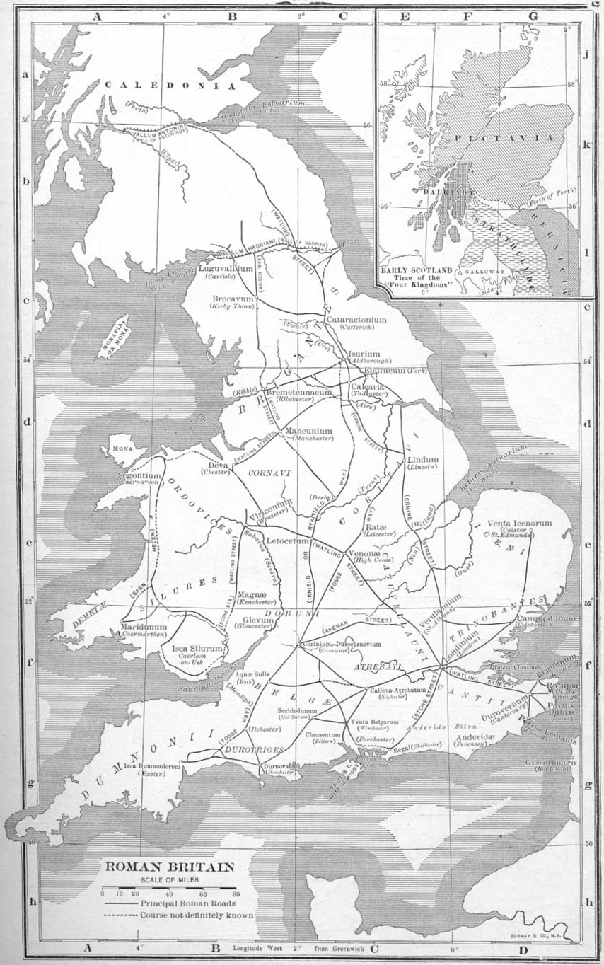
One thing: for Hadrian's Wall to make sense as a one-way border, shouldn't the map theme be set in antiquity? Not much of an obstacle nowadays...

One thing: for Hadrian's Wall to make sense as a one-way border, shouldn't the map theme be set in antiquity? Not much of an obstacle nowadays...
Last edited by jasnostj on Fri Dec 28, 2007 2:41 pm, edited 1 time in total.
-

jasnostj
- Posts: 146
- Joined: Tue May 29, 2007 6:57 am
![]() by Balsiefen on Wed Dec 12, 2007 3:16 am
by Balsiefen on Wed Dec 12, 2007 3:16 am
wicked wrote:OK I wiki'd it.The Scottish Borders (Scottish Gaelic: Crìochan na h-Alba), often referred to simply as the Borders, is one of 32 local government council areas of Scotland.
I see where the other one is sometimes called D&G, so I'll shut up about that one. (although I also see where it's called by their separate names too).
By that it is meaning just the scottish boarders. Gimil's map includes lothian as well so the aria is lothian and boarders. Have a look at some earlier versions of my scotland map compared with the latter where we merged them together
-

Balsiefen
- Posts: 2299
- Joined: Wed Aug 30, 2006 6:15 am
- Location: The Ford of the Aldar in the East of the Kingdom of Lindissi


![]() by hulmey on Wed Dec 12, 2007 9:31 am
by hulmey on Wed Dec 12, 2007 9:31 am
OMG, what time lines are you guys talking about...Do you all want the same naming complaints as before? Choose a timeline and the names are as so!!
Gimil, you seem to be having problems with the Army Circles fitting into counties, most notably Isle of Man!!
Gimil, you seem to be having problems with the Army Circles fitting into counties, most notably Isle of Man!!
[img]http://img801.imageshack.us/img801/9761/41922610151374166770386.jpg[/mg]
-

hulmey
- Posts: 3742
- Joined: Fri Nov 03, 2006 7:33 am
- Location: Las Vegas


![]() by gimil on Wed Dec 12, 2007 10:05 am
by gimil on Wed Dec 12, 2007 10:05 am
hulmey wrote:OMG, what time lines are you guys talking about...Do you all want the same naming complaints as before? Choose a timeline and the names are as so!!
Gimil, you seem to be having problems with the Army Circles fitting into counties, most notably Isle of Man!!
the armie circles are not a problem, there is nothing wrong with them he way they are.
Also im not changing names or time times. Hadriands wall is only in as it was part of the origonal map.
What do you know about map making, bitch?
Top Score:2403
natty_dread wrote:I was wrong
Top Score:2403
-
gimil
- Posts: 8599
- Joined: Sat Mar 03, 2007 12:42 pm
- Location: United Kingdom (Scotland)
Who is online
Users browsing this forum: No registered users
|
|||||||
| Conquer Club is not associated with RISK online in any way. Copyright © 2006-2025 by Big Wham LLC | |||||||