gimil
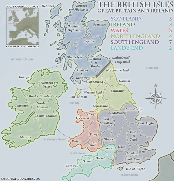
u have tried very hard, largely successfully, to keep the territory boundaries consistent with actual county boundaries (not the easiest job when ur hands are tied by keeping the same gameplay). the only boundary issue remaining here is location of the west midlands: the whole of the west midlands territory needs to be moved down by one county.
http://www.advantagewm.co.uk/the-west-midlands-region/
west midlands just now: shropshire, staffordshire and cheshire excluding wirral
west midlands proposed: official definition, being shropshire, staffordshire, herefordshire, worcestershire and warwickshire, with impassable hills (cotswolds) between warwickshire and oxon
lancashire just now: lancashire and wirral
lancashire proposed: lancashire and whole of cheshire (because cheshire is a north of england county – ever watched hollyoaks?)
midlands just now: contains warwickshire, which makes territory a very odd shape
midlands proposed: remove warwickshire
gloucs just now: gloucs, herefordshire and worcestershire
gloucs proposed: gloucs
unstick the isle of anglesey from gwynedd.
key for abbreviations of long names like gloucestershire, oxfordshire and possibly dumfries & galloway.
is land’s end to keep the same name or be renamed west of england, wessex or something else? i don’t think this was ever resolved. land’s end is the name of only a tiny part of one of the territories in the continent, though it is one of the original author’s idiosyncrasies that some players might like to retain as a homage to the old map.
ian.


