[Official] British Isles REVAMP [Quenched]
Moderator: Cartographers
Re: [Official] British Isles P50 [I, GP, Gr, X] [Final Forge]
![]() by RjBeals on Sun Aug 24, 2008 4:55 pm
by RjBeals on Sun Aug 24, 2008 4:55 pm
Bring back the 3D wall, and keep working on the overall saturation. It's still to washed out.

-

 RjBeals
- Posts: 2506
- Joined: Mon Nov 20, 2006 5:17 pm
- Location: South Carolina, USA


Re: [Official] British Isles P50 [I, GP, Gr, X] [Final Forge]
![]() by edbeard on Sun Aug 24, 2008 5:11 pm
by edbeard on Sun Aug 24, 2008 5:11 pm
RjBeals wrote:Bring back the 3D wall, and keep working on the overall saturation. It's still to washed out.
nah. this wall is FAR superior to any of the previous walls we've seen
-

edbeard
- Posts: 2501
- Joined: Thu Mar 29, 2007 12:41 am


Re: [Official] British Isles P50 [I, GP, Gr, X] [Final Forge]
![]() by gimil on Sun Aug 24, 2008 5:13 pm
by gimil on Sun Aug 24, 2008 5:13 pm
RjBeals wrote:Bring back the 3D wall, and keep working on the overall saturation. It's still to washed out.
Not a chance
What do you know about map making, bitch?
Top Score:2403
natty_dread wrote:I was wrong
Top Score:2403
-

gimil
- Posts: 8599
- Joined: Sat Mar 03, 2007 12:42 pm
- Location: United Kingdom (Scotland)


Re: [Official] British Isles P50 [I, GP, Gr, X] [Final Forge]
![]() by RjBeals on Sun Aug 24, 2008 5:14 pm
by RjBeals on Sun Aug 24, 2008 5:14 pm
It's not better than the 3D wall 
But it's your map. Just like the Halloween map is Mr W.K's.
Don't make me challenge you to an old'skool break dance comp..I may be old.... but I still remember...
But it's your map. Just like the Halloween map is Mr W.K's.
Don't make me challenge you to an old'skool break dance comp..I may be old.... but I still remember...
-
RjBeals
- Posts: 2506
- Joined: Mon Nov 20, 2006 5:17 pm
- Location: South Carolina, USA
Re: [Official] British Isles P50 [I, GP, Gr, X] [Final Forge]
![]() by Thezzaruz on Mon Aug 25, 2008 3:49 am
by Thezzaruz on Mon Aug 25, 2008 3:49 am
yeti_c wrote:I think it might be the extra arrow and legend in the sea - do we need that now?
C.
Not at all, especially since it's hardly readable.
-

Thezzaruz
- Posts: 1093
- Joined: Mon Feb 04, 2008 2:10 pm
- Location: OTF most of the time.

Re: [Official] British Isles P50 [I, GP, Gr, X] [Final Forge]
![]() by gimil on Mon Aug 25, 2008 6:12 am
by gimil on Mon Aug 25, 2008 6:12 am
RjBeals wrote:It's not better than the 3D wall
But it's your map. Just like the Halloween map is Mr W.K's.
Don't make me challenge you to an old'skool break dance comp..I may be old.... but I still remember...
What do you know about map making, bitch?
Top Score:2403
natty_dread wrote:I was wrong
Top Score:2403
-
gimil
- Posts: 8599
- Joined: Sat Mar 03, 2007 12:42 pm
- Location: United Kingdom (Scotland)
Re: [Official] British Isles P50 [I, GP, Gr, X] [Final Forge]
![]() by Noslen on Thu Aug 28, 2008 6:01 am
by Noslen on Thu Aug 28, 2008 6:01 am
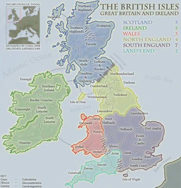
I still think that the mountains between Glous and Gwent are wrong. The malverns are further north (they are in the midlands( west midlans and powis maybe?)...quite a bit further north. Even if you were to have offa's dyke between wales and england it does stretch down that far...
Also the Land's End Label...westcountry would be far better...after all that is what the region is known as. Lands end is less than 1km square.
Also if the Isle of Whight is a territory why is Anglesey (the isle at the top of wales) not a territory?
Also the Land's End Label...westcountry would be far better...after all that is what the region is known as. Lands end is less than 1km square.
Also if the Isle of Whight is a territory why is Anglesey (the isle at the top of wales) not a territory?
-
Noslen
- Posts: 34
- Joined: Mon Apr 28, 2008 6:28 am
- Location: England


Re: [Official] British Isles P50 [I, GP, Gr, X] [Final Forge]
![]() by gimil on Fri Aug 29, 2008 9:14 am
by gimil on Fri Aug 29, 2008 9:14 am
Noslen wrote:I still think that the mountains between Glous and Gwent are wrong. The malverns are further north (they are in the midlands( west midlans and powis maybe?)...quite a bit further north. Even if you were to have offa's dyke between wales and england it does stretch down that far...
Took a little artistic license, this is a REVAMP so I have to keep the gameplay the same.
Also the Land's End Label...westcountry would be far better...after all that is what the region is known as. Lands end is less than 1km square.
Also if the Isle of Whight is a territory why is Anglesey (the isle at the top of wales) not a territory?
Again, a revamp have to give with the gameplay from before.
What do you know about map making, bitch?
Top Score:2403
natty_dread wrote:I was wrong
Top Score:2403
-
gimil
- Posts: 8599
- Joined: Sat Mar 03, 2007 12:42 pm
- Location: United Kingdom (Scotland)
Re: [Official] British Isles P50 [I, GP, Gr, X] [Final Forge]
![]() by blakebowling on Sun Aug 31, 2008 3:22 am
by blakebowling on Sun Aug 31, 2008 3:22 am
gimil wrote:Noslen wrote:I still think that the mountains between Glous and Gwent are wrong. The malverns are further north (they are in the midlands( west midlans and powis maybe?)...quite a bit further north. Even if you were to have offa's dyke between wales and england it does stretch down that far...
Took a little artistic license, this is a REVAMP so I have to keep the gameplay the same.
Also the Land's End Label...westcountry would be far better...after all that is what the region is known as. Lands end is less than 1km square.
Also if the Isle of Whight is a territory why is Anglesey (the isle at the top of wales) not a territory?
Again, a revamp have to give with the gameplay from before.
I thought you could tweak it slightly, but only with the original mapmaker's permission
-
blakebowling
- Posts: 5093
- Joined: Wed Jan 23, 2008 12:09 pm
- Location: 127.0.0.1


Re: [Official] British Isles P50 [I, GP, Gr, X] [Final Forge]
![]() by gimil on Sun Aug 31, 2008 3:34 am
by gimil on Sun Aug 31, 2008 3:34 am
blakebowling wrote:gimil wrote:Noslen wrote:I still think that the mountains between Glous and Gwent are wrong. The malverns are further north (they are in the midlands( west midlans and powis maybe?)...quite a bit further north. Even if you were to have offa's dyke between wales and england it does stretch down that far...
Took a little artistic license, this is a REVAMP so I have to keep the gameplay the same.
Also the Land's End Label...westcountry would be far better...after all that is what the region is known as. Lands end is less than 1km square.
Also if the Isle of Whight is a territory why is Anglesey (the isle at the top of wales) not a territory?
Again, a revamp have to give with the gameplay from before.
I thought you could tweak it slightly, but only with the original mapmaker's permission
Doubt it, punk
What do you know about map making, bitch?
Top Score:2403
natty_dread wrote:I was wrong
Top Score:2403
-
gimil
- Posts: 8599
- Joined: Sat Mar 03, 2007 12:42 pm
- Location: United Kingdom (Scotland)
Re: [Official] British Isles P50 [I, GP, Gr, X] [Final Forge]
![]() by hulmey on Sun Aug 31, 2008 3:43 am
by hulmey on Sun Aug 31, 2008 3:43 am
Whens this map going to be out?
[img]http://img801.imageshack.us/img801/9761/41922610151374166770386.jpg[/mg]
-

hulmey
- Posts: 3742
- Joined: Fri Nov 03, 2006 7:33 am
- Location: Las Vegas


Re: [Official] British Isles P50 [I, GP, Gr, X] [Final Forge]
![]() by gimil on Sun Aug 31, 2008 5:20 am
by gimil on Sun Aug 31, 2008 5:20 am
hulmey wrote:Whens this map going to be out?
Once this backlog is cleared im going full pelt! and get this sucka finished, just for you humley
What do you know about map making, bitch?
Top Score:2403
natty_dread wrote:I was wrong
Top Score:2403
-
gimil
- Posts: 8599
- Joined: Sat Mar 03, 2007 12:42 pm
- Location: United Kingdom (Scotland)
Re: [Official] British Isles P50 [I, GP, Gr, X] [Final Forge]
![]() by gimil on Sun Aug 31, 2008 2:39 pm
by gimil on Sun Aug 31, 2008 2:39 pm
SMALL
LARGE
- Click image to enlarge.
LARGE
- Click image to enlarge.
What do you know about map making, bitch?
Top Score:2403
natty_dread wrote:I was wrong
Top Score:2403
-
gimil
- Posts: 8599
- Joined: Sat Mar 03, 2007 12:42 pm
- Location: United Kingdom (Scotland)
Re: [Official] British Isles P50 [I, GP, Gr, X] [Final Forge]
![]() by foregone on Sun Aug 31, 2008 2:43 pm
by foregone on Sun Aug 31, 2008 2:43 pm
Beautiful map. My only issue right now is that the hadrian's wall text is a little hard to read, particularly on the small map. Looks like you did darken it a bit but I'm still struggling a bit.
-

foregone
- Posts: 289
- Joined: Sun May 11, 2008 1:00 am
- Location: Sydney, NSW, Australia
Re: [Official] British Isles P50 [I, GP, Gr, X] [Final Forge]
![]() by Androidz on Sun Aug 31, 2008 2:45 pm
by Androidz on Sun Aug 31, 2008 2:45 pm
foregone wrote:Beautiful map. My only issue right now is that the hadrian's wall text is a little hard to read, particularly on the small map. Looks like you did darken it a bit but I'm still struggling a bit.
If he do something about the tex there then he need to fix sea names to...

-

Androidz
- Posts: 1046
- Joined: Mon Dec 03, 2007 11:03 am
Re: [Official] British Isles P50 [I, GP, Gr, X] [Final Forge]
![]() by tenio on Sun Aug 31, 2008 10:04 pm
by tenio on Sun Aug 31, 2008 10:04 pm
i think we've come to the point where having to spell out arrow= 1 way attack is unnecessary,
but i guess you could darken the text in small just a little
but i guess you could darken the text in small just a little
-

tenio
- Posts: 174
- Joined: Thu Apr 19, 2007 7:23 pm
- Location: The Moon
Re: [Official] British Isles P50 [I, GP, Gr, X] [Final Forge]
![]() by gimil on Mon Sep 01, 2008 1:33 am
by gimil on Mon Sep 01, 2008 1:33 am
tenio wrote:i think we've come to the point where having to spell out arrow= 1 way attack is unnecessary,
but i guess you could darken the text in small just a little
I might just take the explaination out, I think the arrows are more than enough for the standard competant person!
What do you know about map making, bitch?
Top Score:2403
natty_dread wrote:I was wrong
Top Score:2403
-
gimil
- Posts: 8599
- Joined: Sat Mar 03, 2007 12:42 pm
- Location: United Kingdom (Scotland)
Re: [Official] British Isles P50 [I, GP, Gr, X] [Final Forge]
![]() by yeti_c on Mon Sep 01, 2008 5:17 am
by yeti_c on Mon Sep 01, 2008 5:17 am
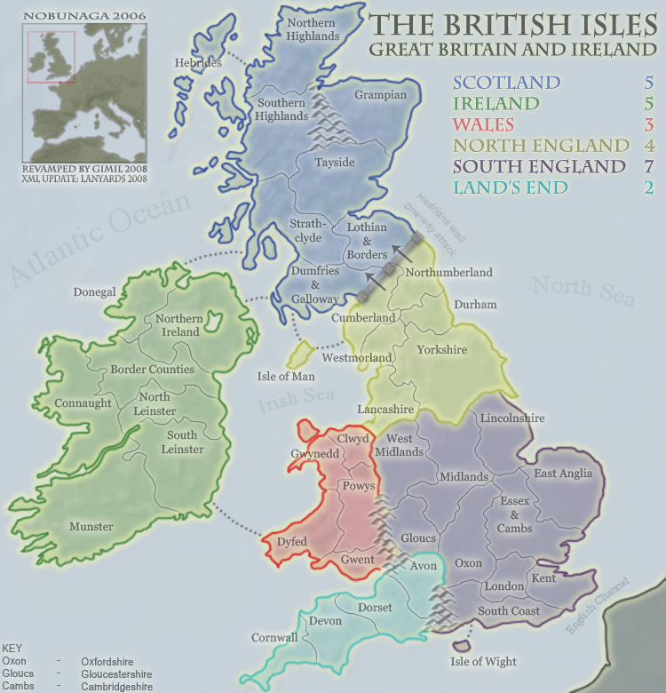
Font in bottom left text is weird.
C.
C.

Highest score : 2297
-

yeti_c
- Posts: 9624
- Joined: Thu Jan 04, 2007 9:02 am


Re: [Official] British Isles P50 [I, GP, Gr, X] [Final Forge]
![]() by cicero on Mon Sep 01, 2008 7:26 am
by cicero on Mon Sep 01, 2008 7:26 am
Agreed.yeti_c wrote:Font in bottom left text is weird.
And (slap me if I'm too late in the process for this) I think that "Lands End" is a really poor name for that 'continent'. Since "Lands End" is the Western most tip of Cornwall. Certainly nothing to do with Devon, Dorset or Avon.
I notice that territory names have been revised in this update so how about continents too ?
"South West England" would be adequate.
"The West Country" or "The South West" would be in keeping with typical UK nomenclature ...
-

cicero
- Posts: 1358
- Joined: Wed Mar 07, 2007 1:51 pm
- Location: with the infected neutrals ... handing out maps to help them find their way to CC

Re: [Official] British Isles P50 [I, GP, Gr, X] [Final Forge]
![]() by gimil on Mon Sep 01, 2008 8:25 am
by gimil on Mon Sep 01, 2008 8:25 am
yeti_c wrote:Font in bottom left text is weird.
C.
And whats weird about it?
What do you know about map making, bitch?
Top Score:2403
natty_dread wrote:I was wrong
Top Score:2403
-
gimil
- Posts: 8599
- Joined: Sat Mar 03, 2007 12:42 pm
- Location: United Kingdom (Scotland)
Re: [Official] British Isles P50 [I, GP, Gr, X] [Final Forge]
![]() by yeti_c on Mon Sep 01, 2008 8:35 am
by yeti_c on Mon Sep 01, 2008 8:35 am
gimil wrote:yeti_c wrote:Font in bottom left text is weird.
C.
And whats weird about it?
Open your eyes and take a look - meant to say in large map only too.
C.
Highest score : 2297
-
yeti_c
- Posts: 9624
- Joined: Thu Jan 04, 2007 9:02 am
Re: [Official] British Isles P50 [I, GP, Gr, X] [Final Forge]
![]() by gimil on Mon Sep 01, 2008 9:27 am
by gimil on Mon Sep 01, 2008 9:27 am
Small
Large
How is this?
- Click image to enlarge.
Large
- Click image to enlarge.
How is this?
What do you know about map making, bitch?
Top Score:2403
natty_dread wrote:I was wrong
Top Score:2403
-
gimil
- Posts: 8599
- Joined: Sat Mar 03, 2007 12:42 pm
- Location: United Kingdom (Scotland)
Re: [Official] British Isles P52 [I, GP, Gr, X] [Final Forge]
![]() by yeti_c on Mon Sep 01, 2008 9:30 am
by yeti_c on Mon Sep 01, 2008 9:30 am
Much better.
C.
C.
Highest score : 2297
-
yeti_c
- Posts: 9624
- Joined: Thu Jan 04, 2007 9:02 am
Re: [Official] British Isles P52 [I, GP, Gr, X] [Final Forge]
![]() by gimil on Mon Sep 01, 2008 9:45 am
by gimil on Mon Sep 01, 2008 9:45 am
Champion!
What do you know about map making, bitch?
Top Score:2403
natty_dread wrote:I was wrong
Top Score:2403
-
gimil
- Posts: 8599
- Joined: Sat Mar 03, 2007 12:42 pm
- Location: United Kingdom (Scotland)
Re: [Official] British Isles P52 [I, GP, Gr, X] [Final Forge]
![]() by max is gr8 on Mon Sep 01, 2008 1:44 pm
by max is gr8 on Mon Sep 01, 2008 1:44 pm
I like the mountains, did you make your own brush?
‹max is gr8› so you're a tee-total healthy-eating sex-addict?
‹New_rules› Everyone has some bad habits
(4th Jan 2010)
‹New_rules› Everyone has some bad habits
(4th Jan 2010)
-

max is gr8
- Posts: 3720
- Joined: Sat Jan 21, 2006 6:44 am
- Location: In a big ball of light sent from the future


Who is online
Users browsing this forum: No registered users
|
|||||||
| Conquer Club is not associated with RISK online in any way. Copyright © 2006-2025 by Big Wham LLC | |||||||