New suggestions:
Make North and South whatever be on two lines, so the words don't spill out of the country.
Take the location inset and move it to the upper left and also make it smaller, unless you're going to put some sort of crest or symbol or whatever up there, in that case, just make the inset smaller.
[Official] British Isles REVAMP [Quenched]
Moderator: Cartographers


![]() by reverend_kyle on Fri Dec 07, 2007 1:20 am
by reverend_kyle on Fri Dec 07, 2007 1:20 am
gimil wrote:Great Britian and Ireland will do, I wanted british isles to try and keep the map in the same place in game finder. But nevermind.
As for the montains ive changed them.
Keep british isles.
The British Isles are as far as I know Great Britain and Ireland.
DANCING MUSTARD FOR POOP IN '08!
-

 reverend_kyle
- Posts: 9250
- Joined: Tue Mar 21, 2006 4:08 pm
- Location: 1000 post club


![]() by hulmey on Fri Dec 07, 2007 4:07 am
by hulmey on Fri Dec 07, 2007 4:07 am
rebelman wrote:hulmey wrote:
So lets move ona nd get to work. First thing is that Northern Irealnd is not and will never be part of EIRE! if this map is goingt o be accurate, as i think you wish it to be then you need to make the changes it that area! You could also try and imagine a unique bonus scheme for that highly specal provinve of Great Britiain!
Northern Ireland is not a province - it constitutes a portion of the province of Ulster. It is now and always will be part of Éire, as Éire is the name of the island as a whole. If you are referring to what the future holds for this politically sensitive region you must have no knowledge of what was contained in the 1997 good Friday Agreement and the latest population and ethnicity projections for the region.
All i know rebel is that my sister served in Northern Ireland and it is part of the United Kingdom! Ireland is not and will never be part of the United Kingdom. We can play with words and sorts, but the fact of the matter is that Northern Ireland is her Majesty's people!
[img]http://img801.imageshack.us/img801/9761/41922610151374166770386.jpg[/mg]
-

hulmey
- Posts: 3742
- Joined: Fri Nov 03, 2006 7:33 am
- Location: Las Vegas


![]() by yeti_c on Fri Dec 07, 2007 4:15 am
by yeti_c on Fri Dec 07, 2007 4:15 am
iancanton wrote:while i understand the concept of the old artwork being retained but the territories being renamed, let's see what gimil can do with the graphics. we can always vote down the revamp if we all think that the old map is superior. the double names are useful at the moment to let us see why some territories are a strange shape. i’m sure they’ll morph into something less unwieldy by the time the shape of each has been finalised.
below is my concept of where to draw the borders in southern england (plus lancashire) to produce identical gameplay together with geographical accuracy and the least strange-shaped territories. thanks to yeti_c for the political map on page 8. gimil, is this list of any help to u?
kent
isle of wight
home counties south (currently "sussex and hampshire"): surrey, sussex and hampshire
home counties north (currently "oxfordshire"): oxfordshire, berkshire, buckinghamshire, hertfordshire, middlesex and bedfordshire
london and essex (currently "london")
cambridgeshire and suffolk (currently "essex and cambridgeshire")
norfolk (currently "east anglia")
lincolnshire
east midlands (currently "central england"): derbyshire, nottinghamshire, leicestershire, rutland and northamptonshire
west midlands or west mercia (currently "cheshire"): shropshire, staffordshire, warwickshire, herefordshire and worcestershire
gloucestershire
lancashire and cheshire (currently "lancashire")
ian.
Just quoting this to keep it current...
C.

Highest score : 2297
-

yeti_c
- Posts: 9624
- Joined: Thu Jan 04, 2007 9:02 am


![]() by MrBenn on Fri Dec 07, 2007 10:14 am
by MrBenn on Fri Dec 07, 2007 10:14 am
reverend_kyle wrote:gimil wrote:Great Britian and Ireland will do, I wanted british isles to try and keep the map in the same place in game finder. But nevermind.
As for the montains ive changed them.
Keep british isles.
The British Isles are as far as I know Great Britain and Ireland.
Keep British Isles.
Great Britain is Mainland Britain (England, Scotland, Wales)
The UK is England, Scotland, Wales, and Northern Island.
The British Isles, is Great Britain and Ireland (and so contains all of England, Scotland, Wales, Northern Ireland, and the Republic of Ireland).
-

MrBenn
- Posts: 6880
- Joined: Wed Nov 21, 2007 9:32 am
- Location: Off Duty


![]() by MrBenn on Fri Dec 07, 2007 11:02 am
by MrBenn on Fri Dec 07, 2007 11:02 am
[quote="gimil"]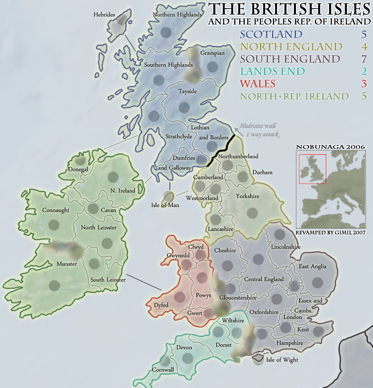
I like the look of this map!
I've read through the thread, and looked at the latest map, and have couple of observations/thoughts:
Gwert should be GWENT
Wiltshire could be renamed AVON (I think this is an alternative name for Bath and Wilts., but not too sure!)
I have a vested interest in Sussex, and where you've got Hampshire (previously Hampshire and Sussex), you could call this area SOUTH COAST.
You could use GLOUCS. instead of Gloucestershire, and LINCS. instead of Lincolnshire
Like other posters, I think you should use MIDLANDS instead of Central England
Somebody mentioned earlier about having Northern/Southern Highlands break onto 2 lines - I think this would look better - probably the same with North/South Leinster
Where you've got the map title, 'The British Isles/and the Peoples Republic of Ireland', how about 'The British Isles:/Great Britain and Ireland'
-
MrBenn
- Posts: 6880
- Joined: Wed Nov 21, 2007 9:32 am
- Location: Off Duty
![]() by gimil on Fri Dec 07, 2007 11:20 am
by gimil on Fri Dec 07, 2007 11:20 am
MrBenn thank you for your input, i will take everything you said into consideration for the next update.
What do you know about map making, bitch?
Top Score:2403
natty_dread wrote:I was wrong
Top Score:2403
-

gimil
- Posts: 8599
- Joined: Sat Mar 03, 2007 12:42 pm
- Location: United Kingdom (Scotland)


![]() by gimil on Fri Dec 07, 2007 11:30 am
by gimil on Fri Dec 07, 2007 11:30 am
Unit_2 wrote:what about the small one? i can't fit it on my screen.
thats becasue its doesnt exist yet.
What do you know about map making, bitch?
Top Score:2403
natty_dread wrote:I was wrong
Top Score:2403
-
gimil
- Posts: 8599
- Joined: Sat Mar 03, 2007 12:42 pm
- Location: United Kingdom (Scotland)
![]() by unriggable on Fri Dec 07, 2007 11:50 am
by unriggable on Fri Dec 07, 2007 11:50 am
The mountains looks like trails of shit.
I think this map is good, but its too big and a lot of space is wasted on useless details, like the map of europe inset. I think it should be shrunk.
I think this map is good, but its too big and a lot of space is wasted on useless details, like the map of europe inset. I think it should be shrunk.

-

unriggable
- Posts: 8037
- Joined: Thu Feb 08, 2007 9:49 pm


![]() by reverend_kyle on Fri Dec 07, 2007 12:03 pm
by reverend_kyle on Fri Dec 07, 2007 12:03 pm
Have I mentioned that the title and legend font look way to childish?
DANCING MUSTARD FOR POOP IN '08!
-
reverend_kyle
- Posts: 9250
- Joined: Tue Mar 21, 2006 4:08 pm
- Location: 1000 post club
![]() by gimil on Fri Dec 07, 2007 12:25 pm
by gimil on Fri Dec 07, 2007 12:25 pm
reverend_kyle wrote:Have I mentioned that the title and legend font look way to childish?
how can a neat and tidy font be presented as childish?
What do you know about map making, bitch?
Top Score:2403
natty_dread wrote:I was wrong
Top Score:2403
-
gimil
- Posts: 8599
- Joined: Sat Mar 03, 2007 12:42 pm
- Location: United Kingdom (Scotland)
![]() by gimil on Fri Dec 07, 2007 12:26 pm
by gimil on Fri Dec 07, 2007 12:26 pm
unriggable wrote:The mountains looks like trails of shit.
I think this map is good, but its too big and a lot of space is wasted on useless details, like the map of europe inset. I think it should be shrunk.
If you read the thread you will be aware that the mountains will be reworked.
and as for the size, this is the large map . . .
What do you know about map making, bitch?
Top Score:2403
natty_dread wrote:I was wrong
Top Score:2403
-
gimil
- Posts: 8599
- Joined: Sat Mar 03, 2007 12:42 pm
- Location: United Kingdom (Scotland)
![]() by I GOT SERVED on Fri Dec 07, 2007 1:17 pm
by I GOT SERVED on Fri Dec 07, 2007 1:17 pm
A few other things:
-Move the army circle on Hebrides so it's in the center of the island, not on the northern end.
-Move the Dumfries and Galloway name a little bit. It looks awkward where it is right now.
-Move the army circle on Hebrides so it's in the center of the island, not on the northern end.
-Move the Dumfries and Galloway name a little bit. It looks awkward where it is right now.

Highest score: 2512
Highest rank: 424
-

I GOT SERVED
- Posts: 1532
- Joined: Fri Jan 26, 2007 9:42 pm
- Location: Good 'ol New England


![]() by Incandenza on Fri Dec 07, 2007 2:06 pm
by Incandenza on Fri Dec 07, 2007 2:06 pm
yeti_c wrote:iancanton wrote:kent
isle of wight
home counties south (currently "sussex and hampshire"): surrey, sussex and hampshire
home counties north (currently "oxfordshire"): oxfordshire, berkshire, buckinghamshire, hertfordshire, middlesex and bedfordshire
london and essex (currently "london")
cambridgeshire and suffolk (currently "essex and cambridgeshire")
norfolk (currently "east anglia")
lincolnshire
east midlands (currently "central england"): derbyshire, nottinghamshire, leicestershire, rutland and northamptonshire
west midlands or west mercia (currently "cheshire"): shropshire, staffordshire, warwickshire, herefordshire and worcestershire
gloucestershire
lancashire and cheshire (currently "lancashire")
ian.
Just quoting this to keep it current...
C.
Are these proposed territory names?
THOTA: dingdingdingdingdingdingBOOM
Te Occidere Possunt Sed Te Edere Non Possunt Nefas Est
Te Occidere Possunt Sed Te Edere Non Possunt Nefas Est
-

Incandenza
- Posts: 4949
- Joined: Thu Oct 19, 2006 5:34 pm
- Location: Playing Eschaton with a bucket of old tennis balls


![]() by gimil on Fri Dec 07, 2007 3:00 pm
by gimil on Fri Dec 07, 2007 3:00 pm
Incandenza wrote:yeti_c wrote:iancanton wrote:kent
isle of wight
home counties south (currently "sussex and hampshire"): surrey, sussex and hampshire
home counties north (currently "oxfordshire"): oxfordshire, berkshire, buckinghamshire, hertfordshire, middlesex and bedfordshire
london and essex (currently "london")
cambridgeshire and suffolk (currently "essex and cambridgeshire")
norfolk (currently "east anglia")
lincolnshire
east midlands (currently "central england"): derbyshire, nottinghamshire, leicestershire, rutland and northamptonshire
west midlands or west mercia (currently "cheshire"): shropshire, staffordshire, warwickshire, herefordshire and worcestershire
gloucestershire
lancashire and cheshire (currently "lancashire")
ian.
Just quoting this to keep it current...
C.
Are these proposed territory names?
yup thats the reworked south england continent
What do you know about map making, bitch?
Top Score:2403
natty_dread wrote:I was wrong
Top Score:2403
-
gimil
- Posts: 8599
- Joined: Sat Mar 03, 2007 12:42 pm
- Location: United Kingdom (Scotland)
![]() by yeti_c on Fri Dec 07, 2007 3:04 pm
by yeti_c on Fri Dec 07, 2007 3:04 pm
gimil wrote:Incandenza wrote:yeti_c wrote:iancanton wrote:kent
isle of wight
home counties south (currently "sussex and hampshire"): surrey, sussex and hampshire
home counties north (currently "oxfordshire"): oxfordshire, berkshire, buckinghamshire, hertfordshire, middlesex and bedfordshire
london and essex (currently "london")
cambridgeshire and suffolk (currently "essex and cambridgeshire")
norfolk (currently "east anglia")
lincolnshire
east midlands (currently "central england"): derbyshire, nottinghamshire, leicestershire, rutland and northamptonshire
west midlands or west mercia (currently "cheshire"): shropshire, staffordshire, warwickshire, herefordshire and worcestershire
gloucestershire
lancashire and cheshire (currently "lancashire")
ian.
Just quoting this to keep it current...
C.
Are these proposed territory names?
yup thats the reworked south england continent
BTW - I'd change a couple...
Cambridgeshire can be on it's own...
Norfolk and Suffolk -> become East Anglia
Put Middlesex and Essex into "Greater London"
Defs call it "West Midlands" & "East Midlands"
Lancashire & Chesire -> Just call this Lancashire (Which is close enough)
C.
Highest score : 2297
-
yeti_c
- Posts: 9624
- Joined: Thu Jan 04, 2007 9:02 am
![]() by gimil on Fri Dec 07, 2007 3:05 pm
by gimil on Fri Dec 07, 2007 3:05 pm
yeti_c wrote:gimil wrote:Incandenza wrote:yeti_c wrote:iancanton wrote:kent
isle of wight
home counties south (currently "sussex and hampshire"): surrey, sussex and hampshire
home counties north (currently "oxfordshire"): oxfordshire, berkshire, buckinghamshire, hertfordshire, middlesex and bedfordshire
london and essex (currently "london")
cambridgeshire and suffolk (currently "essex and cambridgeshire")
norfolk (currently "east anglia")
lincolnshire
east midlands (currently "central england"): derbyshire, nottinghamshire, leicestershire, rutland and northamptonshire
west midlands or west mercia (currently "cheshire"): shropshire, staffordshire, warwickshire, herefordshire and worcestershire
gloucestershire
lancashire and cheshire (currently "lancashire")
ian.
Just quoting this to keep it current...
C.
Are these proposed territory names?
yup thats the reworked south england continent
BTW - I'd change a couple...
Cambridgeshire can be on it's own...
Norfolk and Suffolk -> become East Anglia
Put Middlesex and Essex into "Greater London"
Defs call it "West Midlands" & "East Midlands"
Lancashire & Chesire -> Just call this Lancashire (Which is close enough)
C.
What do you know about map making, bitch?
Top Score:2403
natty_dread wrote:I was wrong
Top Score:2403
-
gimil
- Posts: 8599
- Joined: Sat Mar 03, 2007 12:42 pm
- Location: United Kingdom (Scotland)
![]() by reverend_kyle on Fri Dec 07, 2007 3:42 pm
by reverend_kyle on Fri Dec 07, 2007 3:42 pm
stupid proxies.. see below post.
Last edited by reverend_kyle on Fri Dec 07, 2007 3:44 pm, edited 1 time in total.
DANCING MUSTARD FOR POOP IN '08!
-
reverend_kyle
- Posts: 9250
- Joined: Tue Mar 21, 2006 4:08 pm
- Location: 1000 post club
![]() by reverend_kyle on Fri Dec 07, 2007 3:44 pm
by reverend_kyle on Fri Dec 07, 2007 3:44 pm
@ Look at the serifs in particular they are very childish in how they are in general..
I'd recommend trajan pro. It is alot cleaner and less childish. Or do like you did on your
I'd recommend trajan pro. It is alot cleaner and less childish. Or do like you did on your
DANCING MUSTARD FOR POOP IN '08!
-
reverend_kyle
- Posts: 9250
- Joined: Tue Mar 21, 2006 4:08 pm
- Location: 1000 post club
![]() by Incandenza on Fri Dec 07, 2007 5:27 pm
by Incandenza on Fri Dec 07, 2007 5:27 pm
So you're going to use the double-named countries even in the south, where it's already super cramped?
I'm sorry to have to keep repeating this, but this is not an actual geographical map, it's a game board. I think that the british and irish people that have been posting here need to chill out a bit on absolute geographical fidelity. The current double names look bad enough, and now with what looks like double the number on the table, this map is going to look really cluttered, and correct me if I'm wrong but I've always thought that the goal of a revamp is to improve the look of a map.
For you british and irish blokes, I understand where you're coming from, but by placing so much emphasis on detailed territory names and shouting down anyone that suggests differently, you're failing to take into account that 95% of the people that will play this have never even been to the british isles and aren't looking for territory names of infuriating exactitude. They just want to play on a clean, good-looking map and kick the crap out of their opponents.
Again, please kill the double names.
THOTA: dingdingdingdingdingdingBOOM
Te Occidere Possunt Sed Te Edere Non Possunt Nefas Est
Te Occidere Possunt Sed Te Edere Non Possunt Nefas Est
-
Incandenza
- Posts: 4949
- Joined: Thu Oct 19, 2006 5:34 pm
- Location: Playing Eschaton with a bucket of old tennis balls
Who is online
Users browsing this forum: No registered users
|
|||||||
| Conquer Club is not associated with RISK online in any way. Copyright © 2006-2025 by Big Wham LLC | |||||||