Jesse710 wrote:It's way better than the original
thank you very much for your compliment
Moderator: Cartographers
![]() by gimil on Fri Dec 28, 2007 6:00 pm
by gimil on Fri Dec 28, 2007 6:00 pm
natty_dread wrote:I was wrong


![]() by Lone.prophet on Sat Dec 29, 2007 5:46 am
by Lone.prophet on Sat Dec 29, 2007 5:46 am


![]() by gimil on Sat Dec 29, 2007 6:26 am
by gimil on Sat Dec 29, 2007 6:26 am
Lone.prophet wrote:Why is there a revamp the old map has no problem at all and in my opion looks better than this version. why you want all maps with soft colors?
the bright "hard"colors make the game more overview
natty_dread wrote:I was wrong
![]() by Lone.prophet on Sat Dec 29, 2007 6:29 am
by Lone.prophet on Sat Dec 29, 2007 6:29 am
![]() by gimil on Sat Dec 29, 2007 6:34 am
by gimil on Sat Dec 29, 2007 6:34 am
Lone.prophet wrote:but they are so soft that they almost look the same cant it by a bit "harder"?
natty_dread wrote:I was wrong
![]() by Lone.prophet on Sat Dec 29, 2007 6:43 am
by Lone.prophet on Sat Dec 29, 2007 6:43 am
![]() by gimil on Sat Dec 29, 2007 6:51 am
by gimil on Sat Dec 29, 2007 6:51 am
Lone.prophet wrote:what a load of crap "get involved sooner"
first time i see it and i make a comment and you say get involved sooner?
natty_dread wrote:I was wrong
![]() by Lone.prophet on Sat Dec 29, 2007 6:56 am
by Lone.prophet on Sat Dec 29, 2007 6:56 am
![]() by gimil on Sat Dec 29, 2007 7:08 am
by gimil on Sat Dec 29, 2007 7:08 am
Lone.prophet wrote:i dont see how a small change of color is over hauling the map
and
than another comment or request it isnt really clear which bonus belongs to what continent since there is no clear reverance
natty_dread wrote:I was wrong
![]() by Lone.prophet on Sat Dec 29, 2007 7:12 am
by Lone.prophet on Sat Dec 29, 2007 7:12 am
![]() by lanyards on Sat Dec 29, 2007 11:50 pm
by lanyards on Sat Dec 29, 2007 11:50 pm


 2
2


![]() by lanyards on Sat Dec 29, 2007 11:55 pm
by lanyards on Sat Dec 29, 2007 11:55 pm
Lone.prophet wrote:Why is there a revamp the old map has no problem at all and in my opion looks better than this version. why you want all maps with soft colors?
the bright "hard"colors make the game more overview
2
![]() by lanyards on Sun Dec 30, 2007 12:03 am
by lanyards on Sun Dec 30, 2007 12:03 am
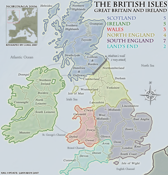
<?xml version="1.0" ?>
<map>
<title>British Isles</title>
<smallwidth>577</smallwidth>
<smallheight>600</smallheight>
<largewidth>750</largewidth>
<largeheight>780</largeheight>
<filetype>png</filetype>
<continent>
<name>Scotland</name>
<bonus>5</bonus>
<components>
<component>Lothian & Borders</component>
<component>Dumfries & Galloway</component>
<component>Grampian</component>
<component>Hebrides</component>
<component>North Highlands</component>
<component>South Highlands</component>
<component>Strathclyde</component>
<component>Tayside</component>
</components>
</continent>
<continent>
<name>Ireland</name>
<bonus>5</bonus>
<components>
<component>Munster</component>
<component>South Leinster</component>
<component>North Leinster</component>
<component>Connaught</component>
<component>Borders</component>
<component>Northern Ireland</component>
<component>Donegal</component>
</components>
</continent>
<continent>
<name>Wales</name>
<bonus>3</bonus>
<components>
<component>Clwyd</component>
<component>Dyfed</component>
<component>Gwent</component>
<component>Gwynedd</component>
<component>Powys</component>
</components>
</continent>
<continent>
<name>North England</name>
<bonus>4</bonus>
<components>
<component>Cumberland</component>
<component>Durham</component>
<component>Isle Of Man</component>
<component>Lancashire</component>
<component>Northumberland</component>
<component>Westmorland</component>
<component>Yorkshire</component>
</components>
</continent>
<continent>
<name>South England</name>
<bonus>7</bonus>
<components>
<component>West Midlands</component>
<component>Midlands</component>
<component>Lincolnshire</component>
<component>Oxon</component>
<component>Essex</component>
<component>East Anglia</component>
<component>South Coast</component>
<component>London</component>
<component>Kent</component>
<component>Isle of Wight</component>
<component>Gloucs.</component>
</components>
</continent>
<continent>
<name>Land's End</name>
<bonus>2</bonus>
<components>
<component>Cornwall</component>
<component>Devon</component>
<component>Dorset</component>
<component>Avon</component>
</components>
</continent>
<territory>
<name>Lothian & Borders</name>
<borders>
<border>Dumfries & Galloway</border>
<border>Strathclyde</border>
<border>Tayside</border>
</borders>
<coordinates>
<smallx>337</smallx>
<smally>230</smally>
<largex>436</largex>
<largey>290</largey>
</coordinates>
</territory>
<territory>
<name>Dumfries & Galloway</name>
<borders>
<border>Lothian & Borders</border>
<border>Isle Of Man</border>
<border>Strathclyde</border>
<border>Northern Ireland</border>
</borders>
<coordinates>
<smallx>288</smallx>
<smally>269</smally>
<largex>361</largex>
<largey>361</largey>
</coordinates>
</territory>
<territory>
<name>Grampian</name>
<borders>
<border>Tayside</border>
</borders>
<coordinates>
<smallx>328</smallx>
<smally>120</smally>
<largex>427</largex>
<largey>146</largey>
</coordinates>
</territory>
<territory>
<name>Hebrides</name>
<borders>
<border>South Highlands</border>
</borders>
<coordinates>
<smallx>178</smallx>
<smally>61</smally>
<largex>231</largex>
<largey>75</largey>
</coordinates>
</territory>
<territory>
<name>North Highlands</name>
<borders>
<border>South Highlands</border>
</borders>
<coordinates>
<smallx>249</smallx>
<smally>79</smally>
<largex>329</largex>
<largey>90</largey>
</coordinates>
</territory>
<territory>
<name>South Highlands</name>
<borders>
<border>Hebrides</border>
<border>North Highlands</border>
<border>Strathclyde</border>
<border>Tayside</border>
</borders>
<coordinates>
<smallx>238</smallx>
<smally>143</smally>
<largex>314</largex>
<largey>180</largey>
</coordinates>
</territory>
<territory>
<name>Strathclyde</name>
<borders>
<border>Lothian & Borders</border>
<border>Donegal</border>
<border>Dumfries & Galloway</border>
<border>South Highlands</border>
<border>Tayside</border>
</borders>
<coordinates>
<smallx>268</smallx>
<smally>231</smally>
<largex>307</largex>
<largey>252</largey>
</coordinates>
</territory>
<territory>
<name>Tayside</name>
<borders>
<border>Lothian & Borders</border>
<border>Grampian</border>
<border>South Highlands</border>
<border>Strathclyde</border>
</borders>
<coordinates>
<smallx>281</smallx>
<smally>183</smally>
<largex>369</largex>
<largey>228</largey>
</coordinates>
</territory>
<territory>
<name>South Leinster</name>
<borders>
<border>Dyfed</border>
<border>Munster</border>
<border>North Leinster</border>
</borders>
<coordinates>
<smallx>153</smallx>
<smally>422</smally>
<largex>200</largex>
<largey>546</largey>
</coordinates>
</territory>
<territory>
<name>Donegal</name>
<borders>
<border>Northern Ireland</border>
<border>Strathclyde</border>
<border>Borders</border>
</borders>
<coordinates>
<smallx>118</smallx>
<smally>280</smally>
<largex>152</largex>
<largey>348</largey>
</coordinates>
</territory>
<territory>
<name>Connaught</name>
<borders>
<border>Borders</border>
<border>North Leinster</border>
</borders>
<coordinates>
<smallx>65</smallx>
<smally>354</smally>
<largex>85</largex>
<largey>455</largey>
</coordinates>
</territory>
<territory>
<name>Northern Ireland</name>
<borders>
<border>Donegal</border>
<border>Dumfries & Galloway</border>
<border>Borders</border>
</borders>
<coordinates>
<smallx>158</smallx>
<smally>282</smally>
<largex>202</largex>
<largey>360</largey>
</coordinates>
</territory>
<territory>
<name>Munster</name>
<borders>
<border>South Leinster</border>
</borders>
<coordinates>
<smallx>83</smallx>
<smally>460</smally>
<largex>94</largex>
<largey>595</largey>
</coordinates>
</territory>
<territory>
<name>Borders</name>
<borders>
<border>Connaught</border>
<border>North Leinster</border>
<border>Donegal</border>
<border>Northern Ireland</border>
</borders>
<coordinates>
<smallx>106</smallx>
<smally>339</smally>
<largex>138</largex>
<largey>439</largey>
</coordinates>
</territory>
<territory>
<name>North Leinster</name>
<borders>
<border>South Leinster</border>
<border>Borders</border>
<border>Connaught</border>
</borders>
<coordinates>
<smallx>166</smallx>
<smally>371</smally>
<largex>215</largex>
<largey>476</largey>
</coordinates>
</territory>
<territory>
<name>Clwyd</name>
<borders>
<border>West Midlands</border>
<border>Gwynedd</border>
<border>Lancashire</border>
<border>Powys</border>
</borders>
<coordinates>
<smallx>306</smallx>
<smally>412</smally>
<largex>399</largex>
<largey>530</largey>
</coordinates>
</territory>
<territory>
<name>Dyfed</name>
<borders>
<border>South Leinster</border>
<border>Gwent</border>
<border>Gwynedd</border>
<border>Powys</border>
</borders>
<coordinates>
<smallx>275</smallx>
<smally>480</smally>
<largex>353</largex>
<largey>621</largey>
</coordinates>
</territory>
<territory>
<name>Gwent</name>
<borders>
<border>Dyfed</border>
<border>Powys</border>
</borders>
<coordinates>
<smallx>303</smallx>
<smally>515</smally>
<largex>394</largex>
<largey>662</largey>
</coordinates>
</territory>
<territory>
<name>Gwynedd</name>
<borders>
<border>Clwyd</border>
<border>Dyfed</border>
<border>Powys</border>
</borders>
<coordinates>
<smallx>284</smallx>
<smally>428</smally>
<largex>370</largex>
<largey>550</largey>
</coordinates>
</territory>
<territory>
<name>Powys</name>
<borders>
<border>West Midlands</border>
<border>Clwyd</border>
<border>Dyfed</border>
<border>Gwent</border>
<border>Gwynedd</border>
</borders>
<coordinates>
<smallx>308</smallx>
<smally>447</smally>
<largex>401</largex>
<largey>577</largey>
</coordinates>
</territory>
<territory>
<name>Cumberland</name>
<borders>
<border>Durham</border>
<border>Dumfries & Galloway</border>
<border>Isle Of Man</border>
<border>Northumberland</border>
<border>Westmorland</border>
</borders>
<coordinates>
<smallx>306</smallx>
<smally>306</smally>
<largex>398</largex>
<largey>392</largey>
</coordinates>
</territory>
<territory>
<name>Durham</name>
<borders>
<border>Cumberland</border>
<border>Northumberland</border>
<border>Westmorland</border>
<border>Yorkshire</border>
</borders>
<coordinates>
<smallx>370</smallx>
<smally>294</smally>
<largex>482</largex>
<largey>377</largey>
</coordinates>
</territory>
<territory>
<name>Isle Of Man</name>
<borders>
<border>Dumfries & Galloway</border>
<border>Cumberland</border>
</borders>
<coordinates>
<smallx>256</smallx>
<smally>326</smally>
<largex>336</largex>
<largey>415</largey>
</coordinates>
</territory>
<territory>
<name>Lancashire</name>
<borders>
<border>West Midlands</border>
<border>Clwyd</border>
<border>Midlands</border>
<border>Westmorland</border>
<border>Yorkshire</border>
</borders>
<coordinates>
<smallx>328</smallx>
<smally>358</smally>
<largex>428</largex>
<largey>458</largey>
</coordinates>
</territory>
<territory>
<name>Northumberland</name>
<borders>
<border>Lothian & Borders</border>
<border>Cumberland</border>
<border>Durham</border>
</borders>
<coordinates>
<smallx>354</smallx>
<smally>270</smally>
<largex>456</largex>
<largey>345</largey>
</coordinates>
</territory>
<territory>
<name>Westmorland</name>
<borders>
<border>Cumberland</border>
<border>Durham</border>
<border>Lancashire</border>
<border>Yorkshire</border>
</borders>
<coordinates>
<smallx>327</smallx>
<smally>318</smally>
<largex>426</largex>
<largey>404</largey>
</coordinates>
</territory>
<territory>
<name>Yorkshire</name>
<borders>
<border>Durham</border>
<border>Lancashire</border>
<border>Lincolnshire</border>
<border>Midlands</border>
<border>Westmorland</border>
</borders>
<coordinates>
<smallx>384</smallx>
<smally>338</smally>
<largex>498</largex>
<largey>434</largey>
</coordinates>
</territory>
<territory>
<name>West Midlands</name>
<borders>
<border>Clwyd</border>
<border>Lancashire</border>
<border>Midlands</border>
<border>Powys</border>
<border>Gloucs.</border>
</borders>
<coordinates>
<smallx>338</smallx>
<smally>400</smally>
<largex>443</largex>
<largey>552</largey>
</coordinates>
</territory>
<territory>
<name>East Anglia</name>
<borders>
<border>Essex</border>
<border>Lincolnshire</border>
</borders>
<coordinates>
<smallx>485</smallx>
<smally>447</smally>
<largex>632</largex>
<largey>575</largey>
</coordinates>
</territory>
<territory>
<name>Essex</name>
<borders>
<border>East Anglia</border>
<border>Oxon</border>
<border>Lincolnshire</border>
<border>London</border>
<border>Midlands</border>
</borders>
<coordinates>
<smallx>441</smallx>
<smally>481</smally>
<largex>576</largex>
<largey>611</largey>
</coordinates>
</territory>
<territory>
<name>Oxon</name>
<borders>
<border>Essex</border>
<border>London</border>
<border>Midlands</border>
<border>Gloucs.</border>
<border>Avon</border>
<border>South Coast</border>
</borders>
<coordinates>
<smallx>400</smallx>
<smally>495</smally>
<largex>518</largex>
<largey>643</largey>
</coordinates>
</territory>
<territory>
<name>Isle of Wight</name>
<borders>
<border>South Coast</border>
</borders>
<coordinates>
<smallx>395</smallx>
<smally>581</smally>
<largex>517</largex>
<largey>748</largey>
</coordinates>
</territory>
<territory>
<name>Kent</name>
<borders>
<border>London</border>
<border>South Coast</border>
</borders>
<coordinates>
<smallx>485</smallx>
<smally>535</smally>
<largex>607</largex>
<largey>680</largey>
</coordinates>
</territory>
<territory>
<name>Lincolnshire</name>
<borders>
<border>East Anglia</border>
<border>Essex</border>
<border>Midlands</border>
<border>Yorkshire</border>
</borders>
<coordinates>
<smallx>431</smallx>
<smally>400</smally>
<largex>563</largex>
<largey>512</largey>
</coordinates>
</territory>
<territory>
<name>London</name>
<borders>
<border>Essex</border>
<border>Oxon</border>
<border>Kent</border>
<border>South Coast</border>
</borders>
<coordinates>
<smallx>440</smallx>
<smally>513</smally>
<largex>569</largex>
<largey>662</largey>
</coordinates>
</territory>
<territory>
<name>Midlands</name>
<borders>
<border>West Midlands</border>
<border>Essex</border>
<border>Oxon</border>
<border>Lancashire</border>
<border>Lincolnshire</border>
<border>Gloucs.</border>
<border>Yorkshire</border>
</borders>
<coordinates>
<smallx>390</smallx>
<smally>414</smally>
<largex>508</largex>
<largey>533</largey>
</coordinates>
</territory>
<territory>
<name>Gloucs.</name>
<borders>
<border>West Midlands</border>
<border>Midlands</border>
<border>Oxon</border>
<border>Avon</border>
</borders>
<coordinates>
<smallx>352</smallx>
<smally>473</smally>
<largex>457</largex>
<largey>609</largey>
</coordinates>
</territory>
<territory>
<name>South Coast</name>
<borders>
<border>Oxon</border>
<border>Isle of Wight</border>
<border>Kent</border>
<border>London</border>
</borders>
<coordinates>
<smallx>397</smallx>
<smally>539</smally>
<largex>519</largex>
<largey>704</largey>
</coordinates>
</territory>
<territory>
<name>Cornwall</name>
<borders>
<border>Devon</border>
</borders>
<coordinates>
<smallx>250</smallx>
<smally>589</smally>
<largex>330</largex>
<largey>759</largey>
</coordinates>
</territory>
<territory>
<name>Devon</name>
<borders>
<border>Cornwall</border>
<border>Dorset</border>
</borders>
<coordinates>
<smallx>284</smallx>
<smally>572</smally>
<largex>370</largex>
<largey>737</largey>
</coordinates>
</territory>
<territory>
<name>Dorset</name>
<borders>
<border>Devon</border>
<border>Avon</border>
</borders>
<coordinates>
<smallx>337</smallx>
<smally>561</smally>
<largex>438</largex>
<largey>721</largey>
</coordinates>
</territory>
<territory>
<name>Avon</name>
<borders>
<border>Dorset</border>
<border>Gloucs.</border>
<border>Oxon</border>
</borders>
<coordinates>
<smallx>362</smallx>
<smally>529</smally>
<largex>470</largex>
<largey>680</largey>
</coordinates>
</territory>
</map>
2
![]() by Incandenza on Sun Dec 30, 2007 12:41 am
by Incandenza on Sun Dec 30, 2007 12:41 am
lanyards wrote:Lone.prophet wrote:Why is there a revamp the old map has no problem at all and in my opion looks better than this version. why you want all maps with soft colors?
the bright "hard"colors make the game more overview
Well, I strongly disagree. This map has way better graphics. The older version didn't even has a water texture. The old one also spelled "Grampian" wrong. In my opinion, the graphics for the old one were kinda lame. Everybody else seems to like this one better also.


![]() by Coleman on Sun Dec 30, 2007 12:46 am
by Coleman on Sun Dec 30, 2007 12:46 am
I just want to comment on this part. Since the original guy asked for the revamp and the geographical extremists had the most complaints about it I find this fair.Incandenza wrote:lanyards wrote:Lone.prophet wrote:Why is there a revamp the old map has no problem at all and in my opion looks better than this version. why you want all maps with soft colors?
the bright "hard"colors make the game more overview
Well, I strongly disagree. This map has way better graphics. The older version didn't even has a water texture. The old one also spelled "Grampian" wrong. In my opinion, the graphics for the old one were kinda lame. Everybody else seems to like this one better also.
Not everyone. I, for one, have been strongly critical of this revamp, especially the fact that geographical extremists have had an undue hand in its development.


![]() by Incandenza on Sun Dec 30, 2007 12:56 am
by Incandenza on Sun Dec 30, 2007 12:56 am
![]() by iancanton on Wed Jan 02, 2008 5:45 pm
by iancanton on Wed Jan 02, 2008 5:45 pm
Incandenza wrote:having a "borders' territory and a "lothian & borders" territory is just asking for trouble


![]() by Incandenza on Wed Jan 02, 2008 8:16 pm
by Incandenza on Wed Jan 02, 2008 8:16 pm
iancanton wrote:Incandenza wrote:having a "borders' territory and a "lothian & borders" territory is just asking for trouble
lothian & borders is actually the name of that part of scotland. on the other hand, the borders territory in ireland has that name only because none of us found a more suitable name after someone objected to "cavan"; any suggestions?
ian.
![]() by fireedud on Wed Jan 02, 2008 8:35 pm
by fireedud on Wed Jan 02, 2008 8:35 pm
lanyards wrote:Lone.prophet wrote:Why is there a revamp the old map has no problem at all and in my opion looks better than this version. why you want all maps with soft colors?
the bright "hard"colors make the game more overview
Well, I strongly disagree. This map has way better graphics. The older version didn't even has a water texture. The old one also spelled "Grampian" wrong. In my opinion, the graphics for the old one were kinda lame. Everybody else seems to like this one better also.


![]() by gimil on Wed Jan 02, 2008 8:40 pm
by gimil on Wed Jan 02, 2008 8:40 pm
natty_dread wrote:I was wrong
![]() by fireedud on Wed Jan 02, 2008 9:03 pm
by fireedud on Wed Jan 02, 2008 9:03 pm
gimil wrote:The mountians have been passed and accepted by discussing already. The wall could use some work.
You comments for "the other map is better" does not belong here and does not help the process in the slightest.
![]() by gimil on Thu Jan 03, 2008 7:51 am
by gimil on Thu Jan 03, 2008 7:51 am
Jesse710 wrote:Is the map going to have the country flag's in the background like your other image?
natty_dread wrote:I was wrong
Users browsing this forum: No registered users
|
|||||||
| Conquer Club is not associated with RISK online in any way. Copyright © 2006-2025 by Big Wham LLC | |||||||