Quad Cities Map [Quenched]
Moderator: Cartographers
Forum rules
Please read the Community Guidelines before posting.
Please read the Community Guidelines before posting.
-
ironsij0287

- Posts: 379
- Joined: Tue Nov 09, 2010 2:30 pm
- Gender: Male
- Location: Dubuque
Re: Quad Cities Map
Oh and losing the drop shadows. No problem.
Re: Quad Cities Map
Ask around, like maybe natty could do you one or two bridges. Just give him credit on the map if he does. IMO he's pretty decent at doing things like that.
-
ironsij0287
- Posts: 379
- Joined: Tue Nov 09, 2010 2:30 pm
- Gender: Male
- Location: Dubuque
Re: Quad Cities Map
isaiah40 wrote:Ask around, like maybe natty could do you one or two bridges. Just give him credit on the map if he does. IMO he's pretty decent at doing things like that.
Yeah I'm cool with that.
Also I just realized there was no beveling along the creeks that flow through the middle of a region, so I took care of that for continuity
-
natty dread

- Posts: 12877
- Joined: Fri Feb 08, 2008 8:58 pm
- Location: just plain fucked
Re: Quad Cities Map
Yeah, I can try doing some bridges for you. Can you give me a version of the large map without any bridges on it?
Also, I think the main problem with the bridge image in the legend is that it looks blurry & out of focus. Especially in the large map. Kinda like it was resized from a smaller image? The same is true for the other bridge, although it is slightly better.
Also, I think the main problem with the bridge image in the legend is that it looks blurry & out of focus. Especially in the large map. Kinda like it was resized from a smaller image? The same is true for the other bridge, although it is slightly better.

-
ironsij0287
- Posts: 379
- Joined: Tue Nov 09, 2010 2:30 pm
- Gender: Male
- Location: Dubuque
Re: Quad Cities Map
Big map without bridges.
[bigimg]http://i11.photobucket.com/albums/a193/ironsij0287/840bridgeless.png[/bigimg]
[bigimg]http://i11.photobucket.com/albums/a193/ironsij0287/840bridgeless.png[/bigimg]
-
natty dread
- Posts: 12877
- Joined: Fri Feb 08, 2008 8:58 pm
- Location: just plain fucked

Re: Quad Cities Map
ironsij0287 wrote:RjBeals wrote:i suggest to remove the drop shadow from the territory fonts.
remove the rounded bridge in the top left of the map, keep the terrain map all the way around
also that bridge image in the bottom legend looks bad also. Is there anything else you can do with that?
Looks like "bridges" is the theme of this map so instead of the white lines as bridges, could you try to make cooler bridges?
Rounded bridge gone, check.
Bottom bridge image - You want me to do some sort of effect on it or something? The image has to remain somewhat muted so the regions stand out over top of it.
Cool bridges - I'm down with this idea but I suck as an artist so drawing my own would probably be bad. Is there any place that has some sort of bridge symbology that I can work with?
He means another image in its place. Another nice looking bridge. Last time I was up there I seem to remember more than 1 bridge crossing the Mississippi.
Highest Rank: 26 Highest Score: 3480


Re: Quad Cities Map
What would be nice would be some sort of random trivia/facts/history about the Quad Cities area that you could add into the dead space, just to give some extra interest to the map.

PB: 2661 | He's blue... If he were green he would die | No mod would be stupid enough to do that
Re: Quad Cities Map
MrBenn wrote:What would be nice would be some sort of random trivia/facts/history about the Quad Cities area that you could add into the dead space, just to give some extra interest to the map.
Yep right here:
isaiah40 wrote:Here's an idea for you to spice it up (no major changes or that), Can you squeeze the legend down just a little and add in a fun fact about the area? I found this here with some interesting facts about the area. I think it would be a good idea to something like this.

Re: Quad Cities Map
Took the Centennial bridge image off and kept the I-74. 
Quad cities = River, rail roads, tractor/harvester manufacturing and farming. Oh and riverboat gambling too.
Home of John Deere and Co. Davenport had a steamboat named after it. Historic Rock Island Lines RR. R.I. Arsenal is very historic and is still a major military manufacturing arsenal. John O'Donnell stadium. Celebration Belle riverboat. Lots of options.
This post was made by jefjef who should be on your ignore list.

drunkmonkey wrote:I'm filing a C&A report right now. Its nice because they have a drop-down for "jefjef".
-
natty dread
- Posts: 12877
- Joined: Fri Feb 08, 2008 8:58 pm
- Location: just plain fucked
Re: Quad Cities Map
Bridges: here's what I have so far...
[bigimg]http://img856.imageshack.us/img856/4197/qbridge.png[/bigimg]
[bigimg]http://img856.imageshack.us/img856/4197/qbridge.png[/bigimg]

Re: Quad Cities Map
the title is a little confusing - you have quad cities, 4 of them, and each represents a bonus region color - except the yellow area. Should Bettendorf be yellow and orange?

Re: Quad Cities Map
East Moline is yellow... so maybe Moline should be 2 colors?
Highest Rank: 26 Highest Score: 3480

Re: Quad Cities Map
or east moline blue
andalusia park is a bit plain
maybe add some bevel emboss effect
and personnaly I think it was better with the bridge image left
but you are doing great
andalusia park is a bit plain
maybe add some bevel emboss effect
and personnaly I think it was better with the bridge image left
but you are doing great
De gueules à la tour d'argent ouverte, crénelée de trois pièces, sommée d'un donjon ajouré, crénelé de deux pièces
Gules an open tower silver, crenellated three parts, topped by a apertured turret, crenellated two parts
Gules an open tower silver, crenellated three parts, topped by a apertured turret, crenellated two parts
-
ironsij0287
- Posts: 379
- Joined: Tue Nov 09, 2010 2:30 pm
- Gender: Male
- Location: Dubuque
Re: Quad Cities Map
Perhaps it should be addressed in the proposed "Facts and History" but the original Quad Cities were Davenport, Rock Island, Moline and East Moline. Later on Bettendorf was included and East Moline was eventually excluded. There are some remnants of the term Quint Cities being used but it never really became popular.
-
natty dread
- Posts: 12877
- Joined: Fri Feb 08, 2008 8:58 pm
- Location: just plain fucked
Re: Quad Cities Map
Ok here's a psd file with the bridges I drew. You can import the bridge layers from it and tweak them if you want... I'm sorry I haven't had time to make them any fancier... hope they'll work out for you.
http://www.fileden.com/files/2010/2/7/2 ... bridge.psd
http://www.fileden.com/files/2010/2/7/2 ... bridge.psd
-
ironsij0287
- Posts: 379
- Joined: Tue Nov 09, 2010 2:30 pm
- Gender: Male
- Location: Dubuque
Re: Quad Cities Map
natty_dread wrote:Ok here's a psd file with the bridges I drew. You can import the bridge layers from it and tweak them if you want... I'm sorry I haven't had time to make them any fancier... hope they'll work out for you.
http://www.fileden.com/files/2010/2/7/2 ... bridge.psd
Thank you. I like how they turned out.
-
ironsij0287
- Posts: 379
- Joined: Tue Nov 09, 2010 2:30 pm
- Gender: Male
- Location: Dubuque
Re: Quad Cities Map
[bigimg]http://i11.photobucket.com/albums/a193/ironsij0287/qcrisk630v4_1.png[/bigimg]
-
ironsij0287
- Posts: 379
- Joined: Tue Nov 09, 2010 2:30 pm
- Gender: Male
- Location: Dubuque
Re: Quad Cities Map
[bigimg]http://i11.photobucket.com/albums/a193/ironsij0287/qcrisk630v4_2.png[/bigimg]
[bigimg]http://i11.photobucket.com/albums/a193/ironsij0287/qcrisk840v4_2.png[/bigimg]
What's different:
- New bridges created by natty_dread. (Do you want me to put your name below mine in the corner of the map?)
- "East Moline" added in Yellow under Quad Cities title.
- Text in upper lefthand corner explaining which cities have made up the Quad Cities over time.
-
natty dread
- Posts: 12877
- Joined: Fri Feb 08, 2008 8:58 pm
- Location: just plain fucked
Re: Quad Cities Map
ironsij0287 wrote:- New bridges created by natty_dread. (Do you want me to put your name below mine in the corner of the map?)
Well I don't think creating the bridges is a large enough job to warrant listing me as a co-creator... but you can add thanks on the map if you like
ironsij0287 wrote:- Text in upper lefthand corner explaining which cities have made up the Quad Cities over time.
Good text.
Also I like what you did with the bridges. The contrast increase works for them.
Re: Quad Cities Map
Bridges are an improvement. The history you are using is very  .
.
The QC has a rich history. The Arsenal, along with being a fort and arsenal, that even has Confederates buried there. River port during the steamboat days. Buffalo Bill. All kinds of stuff.
The QC has a rich history. The Arsenal, along with being a fort and arsenal, that even has Confederates buried there. River port during the steamboat days. Buffalo Bill. All kinds of stuff.
This post was made by jefjef who should be on your ignore list.
drunkmonkey wrote:I'm filing a C&A report right now. Its nice because they have a drop-down for "jefjef".
-
ironsij0287
- Posts: 379
- Joined: Tue Nov 09, 2010 2:30 pm
- Gender: Male
- Location: Dubuque
Re: Quad Cities Map
jefjef wrote:Bridges are an improvement. The history you are using is very
The QC has a rich history. The Arsenal, along with being a fort and arsenal, that even has Confederates buried there. River port during the steamboat days. Buffalo Bill. All kinds of stuff.
I don't have a lot of space up there to put that much. I realize there is a lot of history in the QC but I can't tell that much of it in roughly three sentences.
Re: Quad Cities Map
I would say
this map should be stamped and go live
this map should be stamped and go live
De gueules à la tour d'argent ouverte, crénelée de trois pièces, sommée d'un donjon ajouré, crénelé de deux pièces
Gules an open tower silver, crenellated three parts, topped by a apertured turret, crenellated two parts
Gules an open tower silver, crenellated three parts, topped by a apertured turret, crenellated two parts
Re: Quad Cities Map
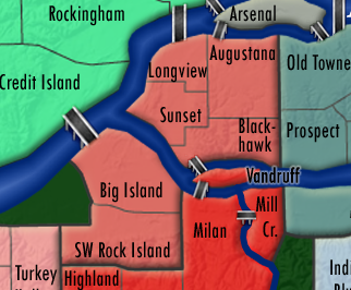
I was never a fan of the isolated areas to complete a bonus. Like the pinkish red (salmon?) color in the bottom left (Rock Isalnd). I would think you would want a bridge connecting Big Island and Sunset. To complete that bonus, you have to fight through 2 or 3 more regions.
-
Victor Sullivan

- Posts: 6010
- Joined: Mon Feb 08, 2010 8:17 pm
- Gender: Male
- Location: Columbus, OH
- Contact:
Re: Quad Cities Map
RjBeals wrote:I was never a fan of the isolated areas to complete a bonus. Like the pinkish red (salmon?) color in the bottom left (Rock Isalnd). I would think you would want a bridge connecting Big Island and Sunset. To complete that bonus, you have to fight through 2 or 3 more regions.
Good spot, RJ! There was actually a bridge there before, but it got left out for some reason... *glares at natty*
[player]Beckytheblondie[/player]: "Don't give us the dispatch, give us a mustache ride."
Scaling back on my CC involvement...
Scaling back on my CC involvement...