Hello everyone, let me introduce you to my new project. As you can tell by the title, Huge Map/Tessellation/River Delta, the final theme of this map is not entirely known. The main goal however is to create a map with an unprecedented number of territories and with a gameplay not seen anywhere else.
Draft:
[bigimg]http://img513.imageshack.us/img513/9519/tessellation1.jpg[/bigimg]
Layout
To accomplish the huge number of territories I have chosen a tessellation (a repeating pattern that leaves no gaps) to create the territories. This idea first came to me from our very own [player]WidowMakers[/player] who proposed a map made entirely of hexagons, a shape that naturally tessellates. I have strayed slightly from that idea, and chosen a combination of octagons and squares because this provides room to label each territory on the territory itself. I personally don't like grid labeling systems because they are a huge headache for users without Clickable Maps, so labeling each territory will be a necessity for this project. As you can see, the naming convention still comes from grid coordinates, where each territory is labeled by row and then column. The rows go from A-X and the columns from A-Z.
Gameplay
The gameplay will be unique simply because this map will have more territories than any other - 312 to be precise. To make things more interesting, I think the map should model a traditional Conquer Club map with one key difference - the impassables which normally divide regions will not actually be impassable. Instead, they will be walls of neutral armies that can be hacked through by the enemy. In this draft I have chosen a river delta as the background image, because deltas naturally divide areas into many small regions. The idea is that every space touched by the river would start as a neutral army in the range of 10-20 troops. Effectively this divides the map into many small areas which will have independent battles. Once a player manages to defeat all of his opponents in a region he is very safe behind the wall of neutrals. However, players will not know exactly where the enemy will try to break through because there are many entry points. Once the wall is broken, the defending player can plug it with his own armies, but that may leave other parts of the region susceptible to further attacks. I think this will create a very interesting game, especially in 8 player games where different regions are captured by each player. Balancing the size and bonus values of each region will have to be a careful task since the map is so large. Additionally I will consider troop reductions similar to the conquer man map, where players don't receive an army for every 3 territories. Instead each player may get a bonus reinforcement for every 5 territories or something similar.
These are my initial thoughts for this map. Eventually the graphics will improve to create a natural looking landscape, but until the gameplay is hammered out I will not put much work into improving the background image.
Your thoughts?
[Abandoned] - Huge Map/Tessellation/River Delta
Moderator: Cartographers
Forum rules
Please read the Community Guidelines before posting.
Please read the Community Guidelines before posting.
-
sully800

- Posts: 4978
- Joined: Wed Jun 14, 2006 5:45 pm
- Gender: Male
- Location: Bethlehem, Pennsylvania
Re: Huge Map/Tessellation/River Delta
(Reserved)
-
Industrial Helix

- Posts: 3462
- Joined: Mon Jul 14, 2008 6:49 pm
- Gender: Female
- Location: Ohio
Re: Huge Map/Tessellation/River Delta
Upon seeing all the hexagons and squares I'm a bit reserved about supporting this map. It kind of reminds me of an over complex map like Actium or something.
If you pick an actual place I might be more interest... for example, Amazon delta or something. Hmm... that would be interesting, maybe with little villages or something for tribes to war over... anyway, I'm not sure if you want to have bonus regions or what. Develop it some more and I might warm up to it.
If you pick an actual place I might be more interest... for example, Amazon delta or something. Hmm... that would be interesting, maybe with little villages or something for tribes to war over... anyway, I'm not sure if you want to have bonus regions or what. Develop it some more and I might warm up to it.
Sketchblog [Update 07/25/11]: http://indyhelixsketch.blogspot.com/
Living in Japan [Update 07/17/11]: http://mirrorcountryih.blogspot.com/
Russian Revolution map for ConquerClub [07/20/11]: viewtopic.php?f=241&t=116575
Living in Japan [Update 07/17/11]: http://mirrorcountryih.blogspot.com/
Russian Revolution map for ConquerClub [07/20/11]: viewtopic.php?f=241&t=116575
-
Evil DIMwit

- Posts: 1616
- Joined: Thu Mar 22, 2007 1:47 pm
- Gender: Male
- Location: Philadelphia, NJ
Re: Huge Map/Tessellation/River Delta
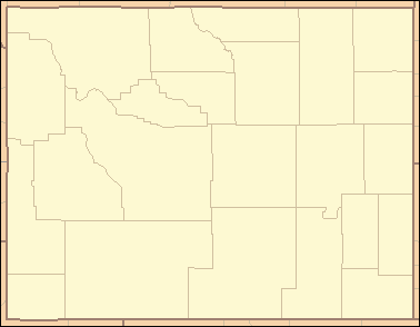
The concept here is very interesting but it does look supremely dull. Perhaps setting it in a real-world location might in fact make it more interesting to play. I propose Wyoming:
Last edited by Evil DIMwit on Sat Aug 15, 2009 12:52 am, edited 1 time in total.
-
sailorseal

- Posts: 2735
- Joined: Sun May 25, 2008 1:49 pm
- Gender: Male
- Location: conquerclub.com
Re: Huge Map/Tessellation/River Delta
Industrial Helix wrote:Upon seeing all the hexagons and squares I'm a bit reserved about supporting this map. It kind of reminds me of an over complex map like Actium or something.
If you pick an actual place I might be more interest... for example, Amazon delta or something. Hmm... that would be interesting, maybe with little villages or something for tribes to war over... anyway, I'm not sure if you want to have bonus regions or what. Develop it some more and I might warm up to it.
I agree with the above. I feel the setup is great for a tribal war given that this shape is perfectly symmetrical and ideal for dividing into sections of different tribes.
-
sully800
- Posts: 4978
- Joined: Wed Jun 14, 2006 5:45 pm
- Gender: Male
- Location: Bethlehem, Pennsylvania
Re: Huge Map/Tessellation/River Delta
The idea is indeed to have bonuses for each region, and an actual river delta like the amazon would be a great way to go.
I'm amused by the Wyoming idea - it actually works almost perfectly with the allotted space but I don't think that will capture the interest of many CC players from around the globe. Maybe not too many americans either!
[bigimg]http://geology.com/press-release/age-of-the-amazon-river/amazon-delta-lg.jpg[/bigimg]
Zooming in and reducing the width of the river in places could make the Amazon work. But it doesn't look as delta-y as I might have hoped. The nile has been overdone with the Egypt series. The Mississippi could work, but there have also been enough American maps in my opinion.
The Amazon is the second longest river in the world (but not far off of the Nile) and has by far the largest flow rate at its mouth. I think it definitely deserves the recognition for this map, it will just require tinkering.
-
sully800
- Posts: 4978
- Joined: Wed Jun 14, 2006 5:45 pm
- Gender: Male
- Location: Bethlehem, Pennsylvania
Re: Huge Map/Tessellation/River Delta
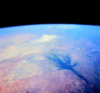
Another very rough draft, this one based on the Amazon. I don't know if it will work though, because the actual river is a mix of very wide and very thin segments. As you can see I had to exaggerate the thin parts and lessen the very wide parts so the final product is not great for gameplay and doesn't resemble to actual Amazon River closely enough. For now I will post it as food for thought.
[bigimg]http://img406.imageshack.us/img406/9472/tessellationdraft2.jpg[/bigimg]
Something like the Lena river delta in Russia is much better for dividing the map into playable areas. But, I don't think the Lena River has any particular attraction, so it is probably not worth constraining myself to a geography that no one knows about. That's why I'm still thinking it might be best to make an imaginary river delta, because the map can be infinitely adjusted to bring about the best possible gameplay. This would be similar to the Oasis map, which takes a particular geographic feature that actual exists but the map is just a stylized and invented oasis. The map plays great, and I think the fact that it is an imaginary oasis does not make it less interesting.
I would still like to include tribes or something for the divided regions, and that could bring an amazon feel to the imaginary location. Hmmm
Last edited by sully800 on Sun Aug 16, 2009 7:45 pm, edited 1 time in total.
-
Scott-Land

- Posts: 2423
- Joined: Tue Jan 23, 2007 9:37 pm
Re: Huge Map/Tessellation/River Delta
Evil DIMwit wrote:The concept here is very interesting but it does look supremely dull. Perhaps setting it in a real-world location might in fact make it more interesting to play. I propose Wyoming:
It wouldn't be a wire-frame .... suppose that's the look he's going for. At least that's what the title indicates.
-
wcaclimbing

- Posts: 5598
- Joined: Fri May 12, 2006 10:09 pm
- Location: In your quantum box....Maybe.
- Contact:
Re: Huge Map/Tessellation/River Delta
This map idea has actually greatly interested me.
I wouldn't have time to create the entire map, but if you want some nicely painted land, i could do it.
If you want help, that is....
I wouldn't have time to create the entire map, but if you want some nicely painted land, i could do it.
If you want help, that is....

-
Evil DIMwit
- Posts: 1616
- Joined: Thu Mar 22, 2007 1:47 pm
- Gender: Male
- Location: Philadelphia, NJ
Re: Huge Map/Tessellation/River Delta
sully800 wrote:Something like the Lena river delta in Russia is much better for dividing the map into playable areas. But, I don't think the Lena River has any particular attraction, so it is probably not worth constraining myself to a geography that no one knows about. That's why I'm still thinking it might be best to make an imaginary river delta, because the map can be infinitely adjusted to bring about the best possible gameplay.
The Lena does have a beautiful delta... To me a real-world location always holds more meaning than an invented one; maybe I'm in the minority. As far as recognizable locations, the Ganges River has a pretty nice delta too, and the fjords of Norway seem to fit.
Anyway, how married are you to the decagons? It's not difficult to tesselate a completely irregular, more natural-looking figure. For example:

If you are going for a rainforesty feel, this may be better than the plain polygons.

Re: Huge Map/Tessellation/River Delta
For something a little more unique and in an underrepresented part of the globe, how about the Okavango Delta in Botswana. It's an inland delta, so the water flows into nothing. You could have a surrounding desert border if you like. Another cool feature that could be the basis of your surrounding neutrals are the termite mounds and salt islands, which sound pretty inhospitable to me (more info in the wiki link above).
Here's a few pics:

You'd obviously need to modify it to make the arms thinner, but remember that even where it looks like water, it's only very shallow and filled with many nasty beasts!
Here's a few pics:
You'd obviously need to modify it to make the arms thinner, but remember that even where it looks like water, it's only very shallow and filled with many nasty beasts!

Silvanus wrote:perch is a North Korean agent to infiltrate south Korean girls
-
thenobodies80

- Posts: 5400
- Joined: Wed Sep 05, 2007 4:30 am
- Gender: Male
- Location: Milan
Re: Huge Map/Tessellation/River Delta
I'm in favour of the original idea/image.
Maybe having the main river with 20 neutrals and its tributaries with only 10...(some random thoughts )
)
I like the idea of an extra troop every 5 territoriese (or something similar), maybe without any zone bonuses.
With this big map could be easier to balance the game moving around rivers.
For example in this imagine you can see that there are some big blocks of neutrals around and a small zone cutted out in the north east.
I've done some small & quick changes: (again random ideas)
or maybe 2 troops each 6 territories.
There are some "zones" with 6 or 12 regions maybe the righ way to start?
Finally , adding a story or a location could help, but there are no so much free space right now....
Waiting your next update.
Keep it on!
Maybe having the main river with 20 neutrals and its tributaries with only 10...(some random thoughts
I like the idea of an extra troop every 5 territoriese (or something similar), maybe without any zone bonuses.
With this big map could be easier to balance the game moving around rivers.
For example in this imagine you can see that there are some big blocks of neutrals around and a small zone cutted out in the north east.
I've done some small & quick changes: (again random ideas)
- from GV-EV-FW to GV-HW-FW
- from IT-JU-KV to IT-JS-KV
- from HK-GL-GM to HK-FK-GM
- from UL-TK-SJ-RG-QF to UL-TK-QJ-RI-OH
- from NO-OP-PQ-QR to NO-OR-PQ-QR
or maybe 2 troops each 6 territories.
There are some "zones" with 6 or 12 regions maybe the righ way to start?
Finally , adding a story or a location could help, but there are no so much free space right now....
Waiting your next update.
Keep it on!
-
Gamefreakguy

- Posts: 419
- Joined: Sat Aug 25, 2007 5:11 pm
- Gender: Male
Re: Huge Map/Tessellation/River Delta
I actually really like this map - neutrals on the river is a cool idea. I think 6 on the main river and 3's for the tribulets would be more appropriate than the previously mentioned values though.
"Never let your fear decide your fate."
"He who controls others may be powerful but he who has mastered himself is mightier still." Lao Tzu
"He who controls others may be powerful but he who has mastered himself is mightier still." Lao Tzu

Re: Huge Map/Tessellation/River Delta
For me is too complicate to play with just coordinate letters as area names ... I confuse very often.
PepeAtila

-
sully800
- Posts: 4978
- Joined: Wed Jun 14, 2006 5:45 pm
- Gender: Male
- Location: Bethlehem, Pennsylvania
Re: Huge Map/Tessellation/River Delta
PepeAtila wrote:For me is too complicate to play with just coordinate letters as area names ... I confuse very often.
That is definitely one of the challenges of very large maps, and I have labeled each territory directly to try and make things easier (as opposed to using a grid system for labeling which would save space but cause a lot more headaches).
Unfortunately, a map like this will only work properly if you have clickable maps. Using drop downs would be a big pain no matter what naming scheme is used since there are over 300 territories. That creates very big drop down lists and it makes finding the proper territory much harder. By labeling each territory directly I hope it's possible to play without Clickable Maps, but it definitely won't be preferred.
-
thenobodies80
- Posts: 5400
- Joined: Wed Sep 05, 2007 4:30 am
- Gender: Male
- Location: Milan
Re: Huge Map/Tessellation/River Delta
[Moved]
It would appear that development of this map has stalled. If the mapmaker wants to continue with the map, then one of the Foundry Moderators will be able to help put the thread back into the Foundry system, after an update has been made.
It would appear that development of this map has stalled. If the mapmaker wants to continue with the map, then one of the Foundry Moderators will be able to help put the thread back into the Foundry system, after an update has been made.