Map name: Second Boer War
Regions: 65
Neutral: 4 regions start neutral (Cutty Shark = 5, Kimberly and Johannesburg = 5, Boer Commando = 5)
Starting places 61 regions:
2 prayers = 15
3 prayers = 15
4 players = 15
5 players = 12
6 players = 10
7 players = 8
8 players = 7
Continents: 8
Designer: CJ Lues
Experience: First map
Description:This map is of the Second Boer War (or Anglo Boer War) in 11 October 1899 until 31 May 1902 between the British Empire and the Dutch-speaking Boer inhabitants of the two independent Boer republics: the South African Republic (Transvaal Republic) and the Orange Free State.
Latest version 2.2:
[bigimg]http://i1115.photobucket.com/albums/k546/A_Team_CC/SBWmapversion3Big.png[/bigimg]
1.1
http://i1115.photobucket.com/albums/k54 ... rWar-1.jpg
1.2
http://i1115.photobucket.com/albums/k54 ... War2-1.jpg
1.3
http://i1115.photobucket.com/albums/k54 ... Wmap-1.png
1.4
http://i1115.photobucket.com/albums/k54 ... BWmap2.png
1.5
http://i1115.photobucket.com/albums/k54 ... BWmap3.png
1.6
http://i1115.photobucket.com/albums/k54 ... BWmap4.png
2.1
http://i1115.photobucket.com/albums/k54 ... on2Big.png
First of all, it’s my first map (but I have been creating our avatars and signatures for “The A-Team http://www.conquerclub.com/player.php?m ... emaya&so=D ”) so feel free do give a lot of advice!
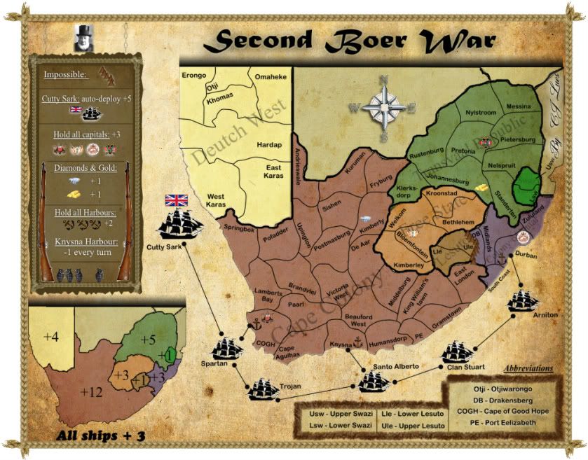
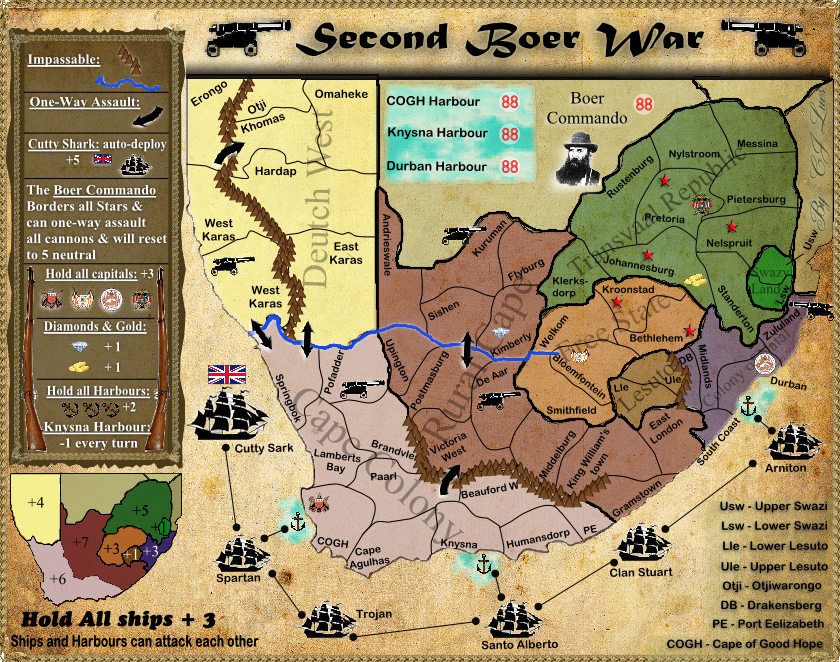
Now for the map itself… It has 65 regains and quite a few bonuses:
8 State bonuses,
a bonus 2 for holding 3 of the capitals (Cape of Good Hope, Bloemfontein, Durban, Pretoria or Hardap)
a bonus 3 for holding all ships,
an auto-deploy of 5 on the Cutty Shark every turn but it will have 5 neutral on it when the game starts (this is to demonstrate the power England had at the time by being able to refresh their armies),
a bonus 3 for the Diamonds in Kimberly and a bonus 3 for the Gold in Johannesburg (witch will be 5 neutral when the game starts to prevent an advantage),
a -1 every turn on Knysna Harbor, because The Knysna Harbor is one of the most dangerous harbors in the WORLD but; a bonus 2 for holding ALL 3 harbors
The Mountains and River are impassable.
The abbreviations are listed in the bottom right corner. The land region names are the real names but, the ship names need some work…?
I think I need some bombarding regions… any suggestions?
Feel free to comment about anything on the map…
Second Boer War
Moderator: Cartographers
Forum rules
Please read the Community Guidelines before posting.
Please read the Community Guidelines before posting.
-
CJ Lues

- Posts: 382
- Joined: Tue Oct 12, 2010 2:25 am
- Gender: Male
- Location: I love a good plan, and i just love it when a plan comes together!
Second Boer War
Last edited by CJ Lues on Sat May 14, 2011 10:34 am, edited 11 times in total.


-
theBastard

- Posts: 994
- Joined: Sat Jan 09, 2010 9:05 am
Re: Second Boer War
looks interesting and I also like graphic. here is very similar map in beta now viewtopic.php?f=64&t=100667
some notices:
1, Cape Colony could be continent divided to two bonus areas
2, the ports could be in another regions as capitals - there is bonus for holding capitals and also for ports, so these regions have "double" bonus.
3, add more mountains
4, why just one boat has autodeploy?
some notices:
1, Cape Colony could be continent divided to two bonus areas
2, the ports could be in another regions as capitals - there is bonus for holding capitals and also for ports, so these regions have "double" bonus.
3, add more mountains
4, why just one boat has autodeploy?
-
Industrial Helix

- Posts: 3462
- Joined: Mon Jul 14, 2008 6:49 pm
- Gender: Female
- Location: Ohio
Re: Second Boer War
Was Mozambique and Namibia even in the Second Boer War?
Sketchblog [Update 07/25/11]: http://indyhelixsketch.blogspot.com/
Living in Japan [Update 07/17/11]: http://mirrorcountryih.blogspot.com/
Russian Revolution map for ConquerClub [07/20/11]: viewtopic.php?f=241&t=116575
Living in Japan [Update 07/17/11]: http://mirrorcountryih.blogspot.com/
Russian Revolution map for ConquerClub [07/20/11]: viewtopic.php?f=241&t=116575

Re: Second Boer War
The travel agent down the road from my work has a big poster in the window for South Africa with something about Rorke's Drift and 11 Victoria Crosses... it made me think of this map (and yes, I do know that Rorke's Drift was 20 years before the Second Boer War)...
You've got a good colour-scheme going on, and there are definite signs of promise here - this really is a good start to your journey through the foundry
My biggest concern really to start is that the small map is almost illegible. Is there any way you can make the land-mass fill more of the map? At the moment you're using about 1/3 of the map for the legend, which is really a bit on the big side. If we can get the layout better, then we can start to think about some way of making the map less of an open free-for-all. Are there any battle lines or anything that can be used as impassables to help give some protection? What about natural features such as rivers, mountains etc?

PB: 2661 | He's blue... If he were green he would die | No mod would be stupid enough to do that
-
CJ Lues
- Posts: 382
- Joined: Tue Oct 12, 2010 2:25 am
- Gender: Male
- Location: I love a good plan, and i just love it when a plan comes together!
Re: Second Boer War
theBastard wrote:looks interesting and I also like graphic. here is very similar map in beta now viewtopic.php?f=64&t=100667
some notices:
1, Cape Colony could be continent divided to two bonus areas
2, the ports could be in another regions as capitals - there is bonus for holding capitals and also for ports, so these regions have "double" bonus.
3, add more mountains
4, why just one boat has autodeploy?
Glad you like the graphic!
Yes i have seen that map... the only problem is that SA did NOT look like that in the 1800's...
Im working on dividing the Cape Colony into 2 parts,
As for the ports and Capitals, im trying to keep it as close to the real history of SA, but will look into it!
Im also working on some more mountains.
I gave some more info on Curry Shark in the main post...
thanx for the advice
-
CJ Lues
- Posts: 382
- Joined: Tue Oct 12, 2010 2:25 am
- Gender: Male
- Location: I love a good plan, and i just love it when a plan comes together!
Re: Second Boer War
grifftron wrote:This is pretty cool, looking forward to seeing what you will turn this into!
thanx grifftron!
-
CJ Lues
- Posts: 382
- Joined: Tue Oct 12, 2010 2:25 am
- Gender: Male
- Location: I love a good plan, and i just love it when a plan comes together!
Re: Second Boer War
Industrial Helix wrote:Was Mozambique and Namibia even in the Second Boer War?
helix, Mozambique and Namibia was not in the Second Boer War...
-
CJ Lues
- Posts: 382
- Joined: Tue Oct 12, 2010 2:25 am
- Gender: Male
- Location: I love a good plan, and i just love it when a plan comes together!
Re: Second Boer War
MrBenn wrote:The travel agent down the road from my work has a big poster in the window for South Africa with something about Rorke's Drift and 11 Victoria Crosses... it made me think of this map (and yes, I do know that Rorke's Drift was 20 years before the Second Boer War)...
You've got a good colour-scheme going on, and there are definite signs of promise here - this really is a good start to your journey through the foundry
My biggest concern really to start is that the small map is almost illegible. Is there any way you can make the land-mass fill more of the map? At the moment you're using about 1/3 of the map for the legend, which is really a bit on the big side. If we can get the layout better, then we can start to think about some way of making the map less of an open free-for-all. Are there any battle lines or anything that can be used as impassables to help give some protection? What about natural features such as rivers, mountains etc?
Yeah, the Rorke's Drift was 20 years before the Second Boer War..
I must say the colour-scheme did come out quite nice....
Ill start working on a bit more land-mass... like i said above ill put in some more mountains, as for rivers, the Boers didnt have a problem crossing them...
thanx for the advice
-
Industrial Helix
- Posts: 3462
- Joined: Mon Jul 14, 2008 6:49 pm
- Gender: Female
- Location: Ohio
Re: Second Boer War
CJ Lues wrote:Industrial Helix wrote:Was Mozambique and Namibia even in the Second Boer War?
helix, Mozambique and Namibia was not in the Second Boer War...
I didn't think so... you might want to remove them from the map then.
Sketchblog [Update 07/25/11]: http://indyhelixsketch.blogspot.com/
Living in Japan [Update 07/17/11]: http://mirrorcountryih.blogspot.com/
Russian Revolution map for ConquerClub [07/20/11]: viewtopic.php?f=241&t=116575
Living in Japan [Update 07/17/11]: http://mirrorcountryih.blogspot.com/
Russian Revolution map for ConquerClub [07/20/11]: viewtopic.php?f=241&t=116575
-
CJ Lues
- Posts: 382
- Joined: Tue Oct 12, 2010 2:25 am
- Gender: Male
- Location: I love a good plan, and i just love it when a plan comes together!
Re: Second Boer War
Industrial Helix wrote:CJ Lues wrote:Industrial Helix wrote:Was Mozambique and Namibia even in the Second Boer War?
helix, Mozambique and Namibia was not in the Second Boer War...
I didn't think so... you might want to remove them from the map then.
Sorry i read the First Question Wrong... Namibia was Deutch West at that time... and was involved in the middle stages of the war... it also gives some more battle field on the map...
Hope it makes sense...
-
CJ Lues
- Posts: 382
- Joined: Tue Oct 12, 2010 2:25 am
- Gender: Male
- Location: I love a good plan, and i just love it when a plan comes together!
Re: Second Boer War
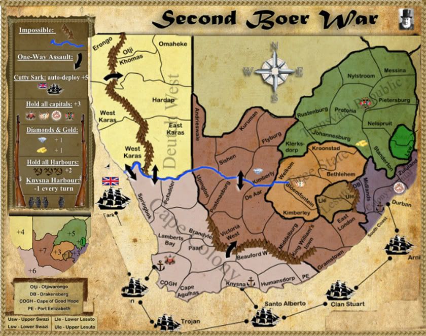
Here is my latest version...
MrBenn, how do you think sould i make the land-mass bigger?
MrBenn, how do you think sould i make the land-mass bigger?
Re: Second Boer War
CJ Lues wrote:Here is my latest version...
It usually helps to give us a quick run-down on the things you have amedned/adjusted/altered, to help point people in the direction and cut down the amount of time we have to spend trying to work out what has changed
CJ Lues wrote:MrBenn, how do you think sould i make the land-mass bigger?
For starters, I would cut down on the white space at the edge of the map, and move some of the legend space around to give me more space for actual map... something like this perhaps:
It's worth noting that this is set up to be around 840px wide, which is at the limit for the large map. You'll need to make sure that everything is legible on the small map too, at 630px wide. Personally I would work on a large-sized image but resize it regularly to ensure things fit and are visible on a smaller image too
PB: 2661 | He's blue... If he were green he would die | No mod would be stupid enough to do that
-
CJ Lues
- Posts: 382
- Joined: Tue Oct 12, 2010 2:25 am
- Gender: Male
- Location: I love a good plan, and i just love it when a plan comes together!
Re: Second Boer War
MrBenn wrote:CJ Lues wrote:Here is my latest version...
It usually helps to give us a quick run-down on the things you have amedned/adjusted/altered, to help point people in the direction and cut down the amount of time we have to spend trying to work out what has changedCJ Lues wrote:MrBenn, how do you think sould i make the land-mass bigger?
For starters, I would cut down on the white space at the edge of the map, and move some of the legend space around to give me more space for actual map... something like this perhaps:
It's worth noting that this is set up to be around 840px wide, which is at the limit for the large map. You'll need to make sure that everything is legible on the small map too, at 630px wide. Personally I would work on a large-sized image but resize it regularly to ensure things fit and are visible on a smaller image too
Ok thanx, Ben...
Im working on the changes!
Do you think i should change the Font of the text on the land names?
-
Industrial Helix
- Posts: 3462
- Joined: Mon Jul 14, 2008 6:49 pm
- Gender: Female
- Location: Ohio
Re: Second Boer War
Maybe its my eyesight or maybe cause its morning... but does a lot of this map seem blurry to anyone else but me?
Sketchblog [Update 07/25/11]: http://indyhelixsketch.blogspot.com/
Living in Japan [Update 07/17/11]: http://mirrorcountryih.blogspot.com/
Russian Revolution map for ConquerClub [07/20/11]: viewtopic.php?f=241&t=116575
Living in Japan [Update 07/17/11]: http://mirrorcountryih.blogspot.com/
Russian Revolution map for ConquerClub [07/20/11]: viewtopic.php?f=241&t=116575
-
natty dread

- Posts: 12877
- Joined: Fri Feb 08, 2008 8:58 pm
- Location: just plain fucked
Re: Second Boer War
Industrial Helix wrote:Maybe its my eyesight or maybe cause its morning... but does a lot of this map seem blurry to anyone else but me?
It seems a bit blurry to me too. Part of it is probably because of the jpg format...

-
Industrial Helix
- Posts: 3462
- Joined: Mon Jul 14, 2008 6:49 pm
- Gender: Female
- Location: Ohio
Re: Second Boer War
I wonder if maybe he text is having a bad effect with the texture? Usually jpgs appear to me quite alright.
Sketchblog [Update 07/25/11]: http://indyhelixsketch.blogspot.com/
Living in Japan [Update 07/17/11]: http://mirrorcountryih.blogspot.com/
Russian Revolution map for ConquerClub [07/20/11]: viewtopic.php?f=241&t=116575
Living in Japan [Update 07/17/11]: http://mirrorcountryih.blogspot.com/
Russian Revolution map for ConquerClub [07/20/11]: viewtopic.php?f=241&t=116575
-
CJ Lues
- Posts: 382
- Joined: Tue Oct 12, 2010 2:25 am
- Gender: Male
- Location: I love a good plan, and i just love it when a plan comes together!
Re: Second Boer War
natty_dread wrote:Industrial Helix wrote:Maybe its my eyesight or maybe cause its morning... but does a lot of this map seem blurry to anyone else but me?
It seems a bit blurry to me too. Part of it is probably because of the jpg format...
What Format would you guys sagest?
-
natty dread
- Posts: 12877
- Joined: Fri Feb 08, 2008 8:58 pm
- Location: just plain fucked
-
CJ Lues
- Posts: 382
- Joined: Tue Oct 12, 2010 2:25 am
- Gender: Male
- Location: I love a good plan, and i just love it when a plan comes together!
Re: Second Boer War
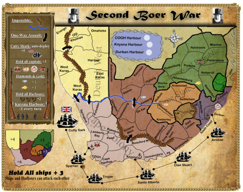
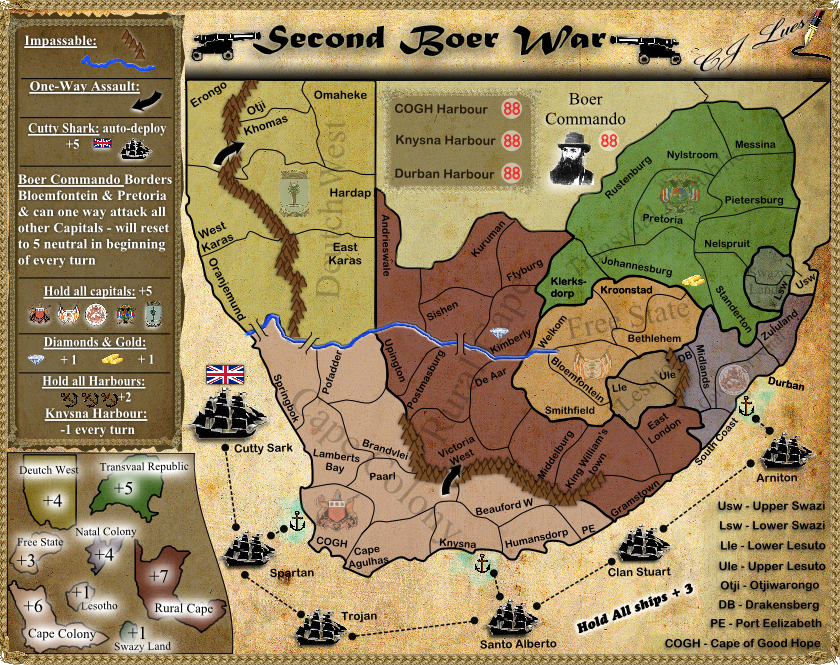
OK, here are the updates on my latest version:
1)Land mass is bigger,
2)mountains and rivers are added,
3)one way attacks,
4)cape colony divided into two parts (upper part still needs a name),
5)harbors are now separate from the other regions (at the top of the map),
[bigimg]http://i1115.photobucket.com/albums/k546/A_Team_CC/SBWmap-1.png[/bigimg]
must i put in the Abbreviations at the bottom right corner???
-
natty dread
- Posts: 12877
- Joined: Fri Feb 08, 2008 8:58 pm
- Location: just plain fucked
-
CJ Lues
- Posts: 382
- Joined: Tue Oct 12, 2010 2:25 am
- Gender: Male
- Location: I love a good plan, and i just love it when a plan comes together!
Re: Second Boer War
natty_dread wrote:You can put them in whatever corner you want.
i actually meant, MUST i put them in?
-
natty dread
- Posts: 12877
- Joined: Fri Feb 08, 2008 8:58 pm
- Location: just plain fucked
-
CJ Lues
- Posts: 382
- Joined: Tue Oct 12, 2010 2:25 am
- Gender: Male
- Location: I love a good plan, and i just love it when a plan comes together!
Re: Second Boer War
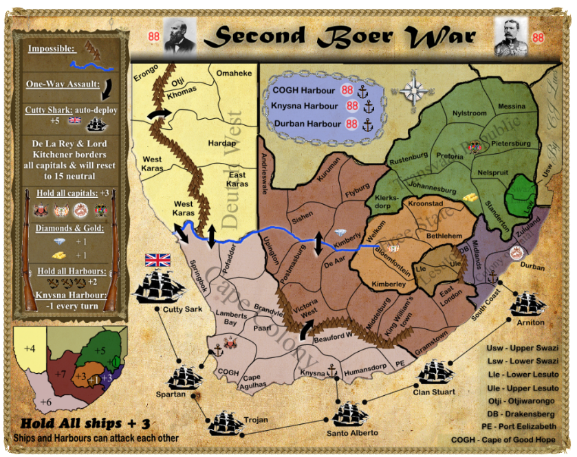
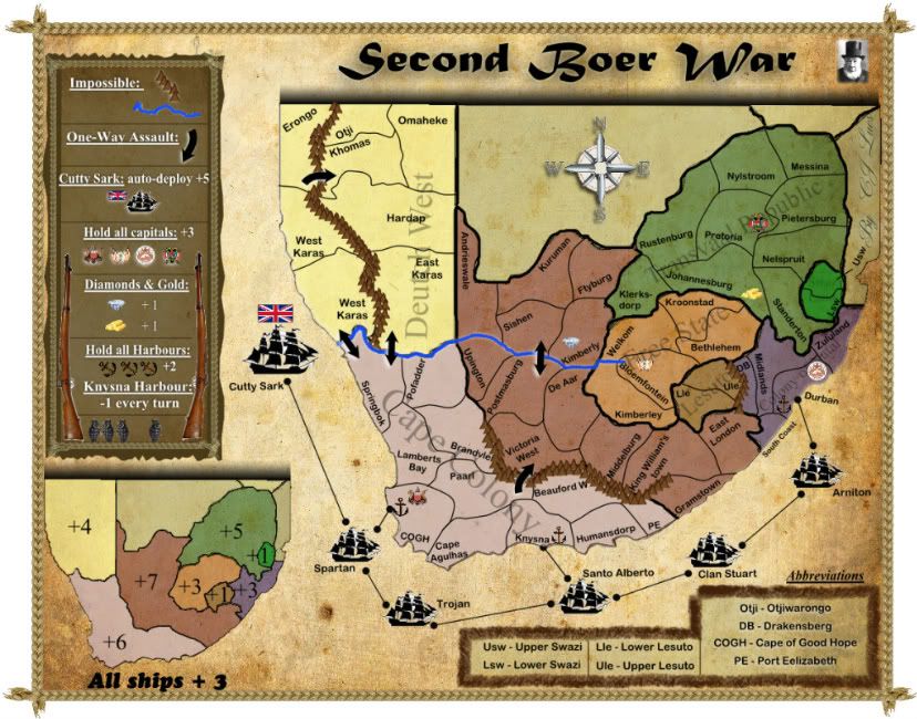
New update:
1) General De La Rey and Lord Kitchener border all capitals and will reset to 15 neutral every turn (is 15 reset enough?),
2) Abbreviations added again
[bigimg]http://i1115.photobucket.com/albums/k546/A_Team_CC/SBWmap2.png[/bigimg]
1) General De La Rey and Lord Kitchener border all capitals and will reset to 15 neutral every turn (is 15 reset enough?),
2) Abbreviations added again
[bigimg]http://i1115.photobucket.com/albums/k546/A_Team_CC/SBWmap2.png[/bigimg]
Re: Second Boer War
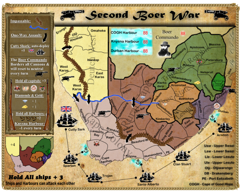
+5 bonus to Cutty Sark seems like a huge bonus to me. That should at the very least start with a large neutral presence.
hehe, does it say 'Impossible'? I like it!
hehe, does it say 'Impossible'? I like it!
