togglable map of connecting territories only

Have suggestion for a new or old tool/enhancement? Come on in!

Moderator: Tech Team

Forum rules
Please read the Community Guidelines before posting.
Post Reply
thegurumonkey
Posts: 13
Joined: Sat Oct 26, 2013 5:52 pm

togglable map of connecting territories only

Post by thegurumonkey »

Hi,
We've all had it where our strategy hinges on a dubious assumption about whether certain territories are connected.
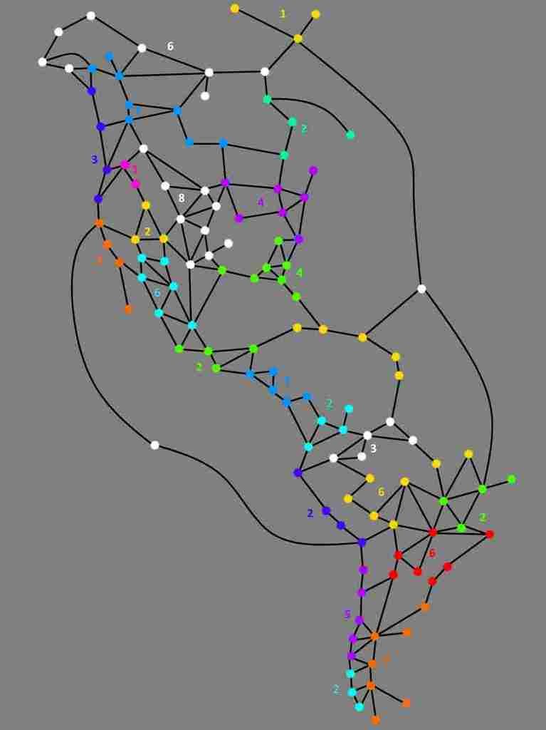
It would be GREAT to have a (very basic) schematic map that you could toggle on to answer any such questions. It need not be beautiful, just functional.

For example, the below is a schematic of the 'First Nations of the Americas' map
Image
User avatar
Dukasaur
Community Team
Community Team
Posts: 28213
Joined: Sat Nov 20, 2010 4:49 pm
Location: Beautiful Niagara

Re: togglable map of connecting territories only

Post by Dukasaur »

thegurumonkey wrote:Hi,
We've all had it where our strategy hinges on a dubious assumption about whether certain territories are connected.
It would be GREAT to have a (very basic) schematic map that you could toggle on to answer any such questions. It need not be beautiful, just functional.

For example, the below is a schematic of the 'First Nations of the Americas' map

Image


Photobucket no longer supports hotlinking. You'll have to rehost that at imageshack or imgur.

In any case, if you're using panel mode, you have a text map available that shows exactly what you're asking for, a list of all the links.

Go to the Settings tab, and change your Text Map to Extended.
Image

Once you do that, in your map tab you will have a detailed list of what territory links to what, like this:
Image

Text map has three levels: Off, Standard (which shows limited information) and Extended (which shows a lot more information.) You can also set settings differently for different maps, so that (for instance) you use Standard on most maps but Extended on the trickier maps.
“‎Life is a shipwreck, but we must not forget to sing in the lifeboats.”
― Voltaire
thegurumonkey
Posts: 13
Joined: Sat Oct 26, 2013 5:52 pm

Re: togglable map of connecting territories only

Post by thegurumonkey »

amazing. never knew all of that was available! it's not quite as intuitive as the thing i was proposing (for seeing defensible areas and bottlenecks) but MUCH better than stabbing in the dark.
Much appreciated. SOLVED!
User avatar
Mad777
Posts: 9884
Joined: Thu Jun 18, 2009 9:21 am

Re: togglable map of connecting territories only

Post by Mad777 »

On mobile device this doesn't work properly, as soon as you trigger the option "Text map", the full map inspect comes ON, you can't reset is to default, the OFF option is not working, admin was made aware few years ago and still not a fix.

Default, Off, Standard, Extended appears as you touch the option button but not a single change within any option, one touch and map inspect turn ON and don't reset.
".....Under Phucumol treatment....."
https://youtu.be/zlusWzDY4qw
Post Reply

Return to “Tools Suggestions”