American Civil War [Quenched]

Care to peruse completed maps? Take a stroll through the Atlas.

Moderator: Cartographers

Forum rules
Please read the Community Guidelines before posting.
Elijah S
Posts: 672
Joined: Wed May 09, 2007 6:24 pm
Gender: Male

Board With Army Numbers

Post by Elijah S »

Image

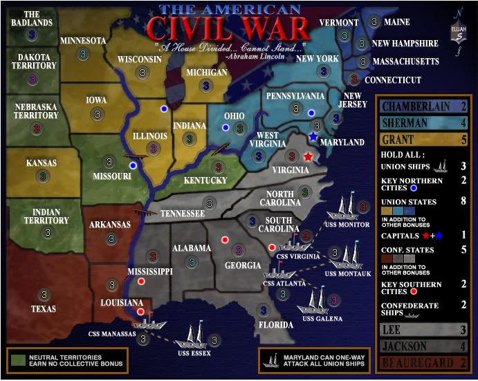
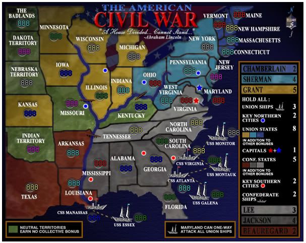
I forgot to crop the perimeter before loading this... so yes I'm aware that the border around it is too big and will fix it.
User avatar
Coleman
Posts: 5402
Joined: Tue Jan 02, 2007 10:36 pm
Gender: Male
Location: Midwest

Post by Coleman »

Once that's the right size, both large and small versions of it are up, and we have working xml I'm beyond satisfied with this.
Warning: You may be reading a really old topic.
User avatar
rebelman
Posts: 2968
Joined: Thu Aug 02, 2007 5:24 pm
Gender: Male
Location: People's Republic of Cork
Contact:

Post by rebelman »

sorry for posting this so late in the day but could you change the color of the ships as they look like they are part of the adjacent territoty

:oops: :oops: sorry i didn't spot / post this sooner

one other comment with the capitals adjacent to ech other and with the huge added benefit of maryland able to one way attack both will be starting as neutrals with maryland being the one with most neutrals on it - or am i wrong ?
Don't now why people on here don't like being cooks, remember under siege: A former SEAL, now cook, is the only person who can stop a gang of terrorists when they sieze control of a US Navy battleship.
User avatar
Coleman
Posts: 5402
Joined: Tue Jan 02, 2007 10:36 pm
Gender: Male
Location: Midwest

Post by Coleman »

Wrong on both counts. Can you really not tell the difference between the ships and the territories they touch? This sounds like a personal problem.
Warning: You may be reading a really old topic.
User avatar
rebelman
Posts: 2968
Joined: Thu Aug 02, 2007 5:24 pm
Gender: Male
Location: People's Republic of Cork
Contact:

Post by rebelman »

Coleman wrote:Wrong on both counts. Can you really not tell the difference between the ships and the territories they touch? This sounds like a personal problem.


the ships to me look the same color as Virginia, tennesee and n carolina - i obviously know they are not part of the continent as i have been following the thread and can also follow the legend but i suspect this will not be the case for many - hence my posting of it here

on the other point not sure what hat i pulled that rabbit out of i was fairly sure it came up in the thread previously but looking back i can't see it. either way this really does not bother me but thew boats color is a biggy i believe.
Don't now why people on here don't like being cooks, remember under siege: A former SEAL, now cook, is the only person who can stop a gang of terrorists when they sieze control of a US Navy battleship.
User avatar
Tisha
Posts: 1065
Joined: Sat Dec 23, 2006 12:41 am

Post by Tisha »

I love the ships just how they are.. they look metal like
User avatar
Unit_2
Posts: 1834
Joined: Sun Jan 14, 2007 12:59 pm
Gender: Male
Location: Pennsylvania, U.S.A, North America, Earth, Milky Way, Universe.

Post by Unit_2 »

Wow, nice army circle :wink:
Image
Elijah S
Posts: 672
Joined: Wed May 09, 2007 6:24 pm
Gender: Male

Post by Elijah S »

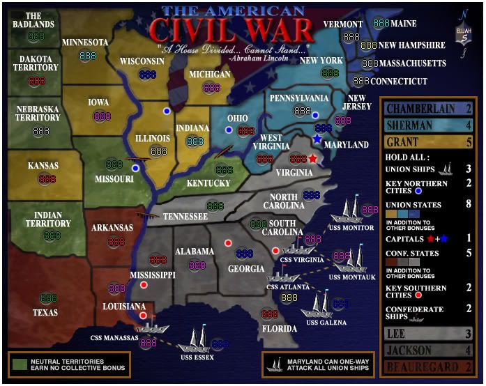
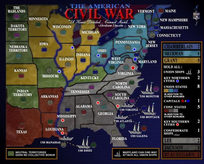
Coleman wrote:Once that's the right size, both large and small versions of it are up, and we have working xml I'm beyond satisfied with this.


Thanks Coleman... My next update will have both size maps and the script.
Probably within the next few days.


Rebelman-
I'm not planning to make any neutral starts in the game.
As is the case with all boards, the luck of the drop is huge, but it's all a matter of chance.

About the ships- I chose the color because they were ironclads and I wanted to illustrate that in some way.
The Legend gives bonuses for holding all union or confederate ships and I think this should sufficiently show that, despite the similarity in colors, they are not part of the grouping for General Lee's territories.

Thanks Tisha and Unit 2! A little encouragement sometimes goes a long way, and you guys just made my day...
User avatar
AndyDufresne
Posts: 24935
Joined: Fri Mar 03, 2006 8:22 pm
Location: A Banana Palm in Zihuatanejo
Contact:

Post by AndyDufresne »

I think the ship color and placement is near spot on. :) Good work, Elijah!


--Andy
User avatar
yeti_c
Posts: 9624
Joined: Thu Jan 04, 2007 9:02 am
Gender: Male

Post by yeti_c »

Yeah I think that ships are fine...

C.
Image
Highest score : 2297
Chirondom
Posts: 77
Joined: Wed Jul 04, 2007 5:51 pm

Post by Chirondom »

The map shouldn't be cropped. It looks ackward like that.
User avatar
spiesr
Posts: 2809
Joined: Mon May 08, 2006 10:52 am
Location: South Dakota

Post by spiesr »

The blue armies in Chamberlain may be a little hard to read. Can someone with bad eyes check this?
User avatar
Qwert
SoC Training Adviser
Posts: 9262
Joined: Tue Nov 07, 2006 5:07 pm
Location: VOJVODINA
Contact:

Post by Qwert »

I must say that bonuses for Lee and Confederation ships is not corect.
Lee have 3 terittory,and all 3 terittory have attacabile borders and you get only 1.Confederation ship you have 3 and only get 1,but for North shops have 4 and you get 3 bonuses,i think that these not correct,
Image
NEW REVOLUTION-NEW RANKS PRESS THESE LINK viewtopic.php?f=471&t=47578&start=0
User avatar
rebelman
Posts: 2968
Joined: Thu Aug 02, 2007 5:24 pm
Gender: Male
Location: People's Republic of Cork
Contact:

Post by rebelman »

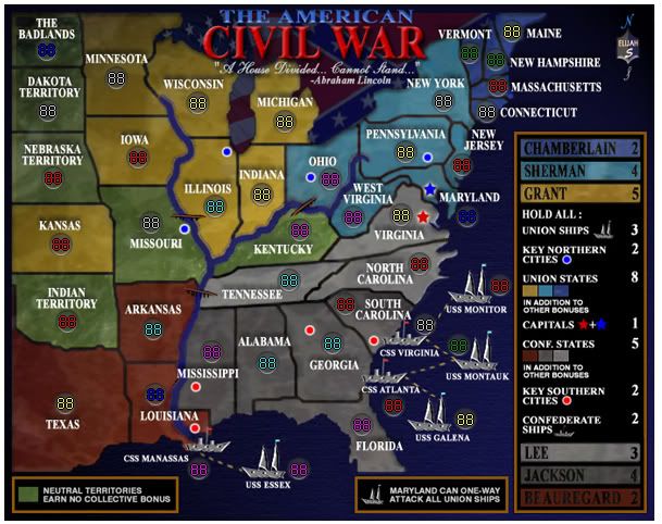
spiesr wrote:The blue armies in Chamberlain may be a little hard to read. Can someone with bad eyes check this?


can't speak for anyone else, but i can read them fine and my eyesight is far from perfect.

on the ships i think they look great and when i'm playing i obviously will know better as i have been following this thread and i ALWAYS read the legend - i do predict others will moan about this though when it gos into live play when the colors are so similar - i hope im wrong because this to me is a beautiful map that i am looking forward to playing and the ships do look well the color they are and when you add in the point about the iron clad then if anything its the territory color should change so its not almost the same as the ships as distinct from the other way around.

Anyway I notice Coleman, Andy and some foundry regulars have already disagreed with me (as usual) so we will see how things unfold - i wanted to make sure you were fully aware of this potential problem prior to this map being quenched.
Don't now why people on here don't like being cooks, remember under siege: A former SEAL, now cook, is the only person who can stop a gang of terrorists when they sieze control of a US Navy battleship.
Suzy1
Posts: 269
Joined: Sat May 12, 2007 3:25 am

...

Post by Suzy1 »

I honestly cannot see any reason for the ships to be changed in any way, yet again. The legend is legible and precise. I think the colors of this map are far better than a few I have seen in other maps that have already been quenched. The game play of this map is quite accurate and the bonuses, as in other games here will either be an advantage or vice versa depending on placement and dice. The one thing I do agree with though, is that someone will find something to moan about. I truly believe this will be one of the most played maps here once it is in play. Good luck Elijah :wink:
Elijah S
Posts: 672
Joined: Wed May 09, 2007 6:24 pm
Gender: Male

XML for ACW

Post by Elijah S »

I checked the xml and army number placement using the CC Map tester and everything seems to line up well...


<map>
<title>The American Civil War</title>
<smallwidth>598</smallwidth>
<smallheight>475</smallheight>
<largewidth>690</largewidth>
<largeheight>548</largeheight>
<filetype>jpg</filetype>

<continent>
<name>Neutral States</name>
<bonus>0</bonus>

<components>
<component>The Badlands</component>
<component>Dakota Territory</component>
<component>Nebraska Territory</component>
<component>Missouri</component>
<component>Indian Territory</component>
<component>Kentucky</component>
</components>
</continent>

<continent>
<name>Grant</name>
<bonus>5</bonus>

<components>
<component>Minnesota</component>
<component>Iowa</component>
<component>Kansas</component>
<component>Wisconsin</component>
<component>Illinois</component>
<component>Michigan</component>
<component>Indiana</component>
</components>
</continent>

<continent>
<name>Beauregard</name>
<bonus>2</bonus>

<components>
<component>Texas</component>
<component>Louisiana</component>
<component>Arkansas</component>
</components>
</continent>

<continent>
<name>Sherman</name>
<bonus>4</bonus>

<components>
<component>Ohio</component>
<component>New York</component>
<component>Pennsylvania</component>
<component>West Virginia</component>
<component>Maryland</component>
<component>New Jersey</component>
</components>
</continent>

<continent>
<name>Chamberlain</name>
<bonus>2</bonus>

<components>
<component>Connecticut</component>
<component>Massachusetts</component>
<component>New Hampshire</component>
<component>Vermont</component>
<component>Maine</component>
</components>
</continent>

<continent>
<name>Lee</name>
<bonus>3</bonus>

<components>
<component>Virginia</component>
<component>North Carolina</component>
<component>Tennessee</component>
</components>
</continent>

<continent>
<name>Jackson</name>
<bonus>4</bonus>

<components>
<component>Mississippi</component>
<component>Alabama</component>
<component>Georgia</component>
<component>South Carolina</component>
<component>Florida</component>
</components>
</continent>

<continent>
<name>Confederate Ships</name>
<bonus>2</bonus>

<components>
<component>CSS Manassas</component>
<component>CSS Atlanta</component>
<component>CSS Virginia</component>
</components>
</continent>


<continent>
<name>Union Ships</name>
<bonus>3</bonus>

<components>
<component>USS Monitor</component>
<component>USS Montauk</component>
<component>USS Galena</component>
<component>USS Essex</component>
</components>
</continent>

<continent>
<name>Key Southern Cities</name>
<bonus>2</bonus>

<components>
<component>Louisiana</component>
<component>Georgia</component>
<component>South Carolina</component>
<component>Mississippi</component>
</components>
</continent>

<continent>
<name>Key Northern Cities</name>
<bonus>2</bonus>

<components>
<component>Missouri</component>
<component>Illinois</component>
<component>Ohio</component>
<component>Pennsylvania</component>
</components>
</continent>

<continent>
<name>Capitals</name>
<bonus>1</bonus>

<components>
<component>Maryland</component>
<component>Virginia</component>
</components>
</continent>
<continent>
<name>All Confederate States</name>
<bonus>5</bonus>

<components>
<component>Mississippi</component>
<component>Alabama</component>
<component>Georgia</component>
<component>South Carolina</component>
<component>Florida</component>
<component>Texas</component>
<component>Louisiana</component>
<component>Arkansas</component>
<component>Virginia</component>
<component>North Carolina</component>
<component>Tennessee</component>
</components>
</continent>

<continent>
<name>All Union States</name>
<bonus>8</bonus>

<components>
<component>Ohio</component>
<component>New York</component>
<component>Pennsylvania</component>
<component>West Virginia</component>
<component>Maryland</component>
<component>New Jersey</component>
<component>Connecticut</component>
<component>Massachusetts</component>
<component>New Hampshire</component>
<component>Vermont</component>
<component>Maine</component>
<component>Minnesota</component>
<component>Iowa</component>
<component>Kansas</component>
<component>Wisconsin</component>
<component>Illinois</component>
<component>Michigan</component>
<component>Indiana</component>
</components>
</continent>


<territory>
<name>The Badlands</name>

<borders>
<border>Minnesota</border>
<border>Dakota Territory</border>
</borders>

<coordinates>
<smallx>35</smallx>
<smally>64</smally>
<largex>41</largex>
<largey>71</largey>
</coordinates>
</territory>

<territory>
<name>Dakota Territory</name>

<borders>
<border>The Badlands</border>
<border>Minnesota</border>
<border>Iowa</border>
<border>Nebraska Territory</border>
</borders>

<coordinates>
<smallx>36</smallx>
<smally>120</smally>
<largex>42</largex>
<largey>135</largey>
</coordinates>
</territory>

<territory>
<name>Nebraska Territory</name>

<borders>
<border>Dakota Territory</border>
<border>Iowa</border>
<border>Missouri</border>
<border>Kansas</border>
</borders>

<coordinates>
<smallx>41</smallx>
<smally>182</smally>
<largex>48</largex>
<largey>207</largey>
</coordinates>
</territory>

<territory>
<name>Missouri</name>

<borders>
<border>Nebraska Territory</border>
<border>Iowa</border>
<border>Illinois</border>
<border>Arkansas</border>
<border>Indian Territory</border>
<border>Kansas</border> </borders>

<coordinates>
<smallx>131</smallx>
<smally>223</smally>
<largex>153</largex>
<largey>255</largey>
</coordinates>
</territory>

<territory>
<name>Indian Territory</name>

<borders>
<border>Kansas</border>
<border>Missouri</border>
<border>Arkansas</border>
<border>Texas</border>
</borders>

<coordinates>
<smallx>54</smallx>
<smally>314</smally>
<largex>64</largex>
<largey>357</largey>
</coordinates>
</territory>

<territory>
<name>Kentucky</name>

<borders>
<border>Ohio</border>
<border>West Virginia</border>
<border>Virginia</border>
<border>Tennessee</border>
</borders>

<coordinates>
<smallx>268</smallx>
<smally>230</smally>
<largex>311</largex>
<largey>263</largey>
</coordinates>
</territory>

<territory>
<name>Minnesota</name>

<borders>
<border>Wisconsin</border>
<border>Iowa</border>
<border>Dakota Territory</border>
<border>The Badlands</border>
</borders>

<coordinates>
<smallx>99</smallx>
<smally>90</smally>
<largex>115</largex>
<largey>99</largey>
</coordinates>
</territory>

<territory>
<name>Iowa</name>

<borders>
<border>Minnesota</border>
<border>Missouri</border>
<border>Nebraska Territory</border>
<border>Dakota Territory</border>
</borders>

<coordinates>
<smallx>119</smallx>
<smally>163</smally>
<largex>136</largex>
<largey>186</largey>
</coordinates>
</territory>

<territory>
<name>Kansas</name>

<borders>
<border>Nebraska Territory</border>
<border>Missouri</border>
<border>Indian Territory</border>
</borders>

<coordinates>
<smallx>48</smallx>
<smally>243</smally>
<largex>57</largex>
<largey>276</largey>
</coordinates>
</territory>

<territory>
<name>Wisconsin</name>

<borders>
<border>Minnesota</border>
<border>Illinois</border>
</borders>

<coordinates>
<smallx>174</smallx>
<smally>113</smally>
<largex>201</largex>
<largey>126</largey>
</coordinates>
</territory>

<territory>
<name>Illinois</name>

<borders>
<border>Wisconsin</border>
<border>Indiana</border>
<border>Missouri</border>
</borders>

<coordinates>
<smallx>190</smallx>
<smally>208</smally>
<largex>217</largex>
<largey>236</largey>
</coordinates>
</territory>

<territory>
<name>Michigan</name>

<borders>
<border>Ohio</border>
<border>Indiana</border>
</borders>

<coordinates>
<smallx>254</smallx>
<smally>130</smally>
<largex>293</largex>
<largey>145</largey>
</coordinates>
</territory>

<territory>
<name>Indiana</name>

<borders>
<border>Michigan</border>
<border>Ohio</border>
<border>Illinois</border>
</borders>

<coordinates>
<smallx>233</smallx>
<smally>197</smally>
<largex>269</largex>
<largey>222</largey>
</coordinates>
</territory>

<territory>
<name>Texas</name>

<borders>
<border>Indian Territory</border>
<border>Arkansas</border>
<border>Louisiana</border>
</borders>

<coordinates>
<smallx>52</smallx>
<smally>389</smally>
<largex>59</largex>
<largey>447</largey>
</coordinates>
</territory>

<territory>
<name>Louisiana</name>

<borders>
<border>Arkansas</border>
<border>Mississippi</border>
<border>Texas</border>
<border>CSS Manassas</border>
</borders>

<coordinates>
<smallx>135</smallx>
<smally>381</smally>
<largex>157</largex>
<largey>433</largey>
</coordinates>
</territory>

<territory>
<name>Arkansas</name>

<borders>
<border>Missouri</border>
<border>Tennessee</border>
<border>Louisiana</border>
<border>Texas</border>
<border>Indian Territory</border>
</borders>

<coordinates>
<smallx>133</smallx>
<smally>321</smally>
<largex>156</largex>
<largey>366</largey>
</coordinates>
</territory>

<territory>
<name>Ohio</name>

<borders>
<border>Michigan</border>
<border>Pennsylvania</border>
<border>Kentucky</border>
<border>Indiana</border>
</borders>

<coordinates>
<smallx>296</smallx>
<smally>183</smally>
<largex>342</largex>
<largey>207</largey>
</coordinates>
</territory>

<territory>
<name>New York</name>

<borders>
<border>Vermont</border>
<border>Massachusetts</border>
<border>Connecticut</border>
<border>New Jersey</border>
<border>Pennsylvania</border>
</borders>

<coordinates>
<smallx>400</smallx>
<smally>111</smally>
<largex>463</largex>
<largey>124</largey>
</coordinates>
</territory>

<territory>
<name>Pennsylvania</name>

<borders>
<border>New York</border>
<border>New Jersey</border>
<border>Maryland</border>
<border>West Virginia</border>
<border>Ohio</border>
</borders>

<coordinates>
<smallx>365</smallx>
<smally>158</smally>
<largex>423</largex>
<largey>178</largey>
</coordinates>
</territory>

<territory>
<name>West Virginia</name>

<borders>
<border>Pennsylvania</border>
<border>Maryland</border>
<border>Virginia</border>
<border>Kentucky</border>
</borders>

<coordinates>
<smallx>317</smallx>
<smally>218</smally>
<largex>369</largex>
<largey>247</largey>
</coordinates>
</territory>

<territory>
<name>Maryland</name>

<borders>
<border>Pennsylvania</border>
<border>New Jersey</border>
<border>Virginia</border>
<border>West Virginia</border>
<border>USS Monitor</border>
<border>USS Montauk</border>
<border>USS Galena</border>
<border>USS Essex</border>
</borders>

<coordinates>
<smallx>422</smallx>
<smally>217</smally>
<largex>453</largex>
<largey>203</largey>
</coordinates>
</territory>

<territory>
<name>New Jersey</name>

<borders>
<border>New York</border>
<border>Maryland</border>
<border>Pennsylvania</border>
</borders>

<coordinates>
<smallx>417</smallx>
<smally>170</smally>
<largex>481</largex>
<largey>192</largey>
</coordinates>
</territory>

<territory>
<name>Connecticut</name>

<borders>
<border>Massachusetts</border>
<border>New York</border>

</borders>

<coordinates>
<smallx>440</smallx>
<smally>121</smally>
<largex>507</largex>
<largey>135</largey>
</coordinates>
</territory>

<territory>
<name>Massachusetts</name>

<borders>
<border>Vermont</border>
<border>New Hampshire</border>
<border>Connecticut</border>
<border>New York</border>

</borders>

<coordinates>
<smallx>450</smallx>
<smally>97</smally>
<largex>520</largex>
<largey>110</largey>
</coordinates>
</territory>

<territory>
<name>New Hampshire</name>

<borders>
<border>Maine</border>
<border>Massachusetts</border>
<border>Vermont</border>
</borders>

<coordinates>
<smallx>448</smallx>
<smally>73</smally>
<largex>518</largex>
<largey>84</largey>
</coordinates>
</territory>

<territory>
<name>Vermont</name>

<borders>
<border>New Hampshire</border>
<border>Massachusetts</border>
<border>New York</border>
</borders>

<coordinates>
<smallx>424</smallx>
<smally>67</smally>
<largex>493</largex>
<largey>72</largey>
</coordinates>
</territory>

<territory>
<name>Maine</name>

<borders>
<border>New Hampshire</border>

</borders>

<coordinates>
<smallx>463</smallx>
<smally>47</smally>
<largex>536</largex>
<largey>52</largey>
</coordinates>
</territory>

<territory>
<name>Virginia</name>

<borders>
<border>West Virginia</border>
<border>Maryland</border>
<border>North Carolina</border>
<border>Tennessee</border>
<border>Kentucky</border>
</borders>

<coordinates>
<smallx>361</smallx>
<smally>216</smally>
<largex>417</largex>
<largey>247</largey>
</coordinates>
</territory>

<territory>
<name>North Carolina</name>

<borders>
<border>Virginia</border>
<border>South Carolina</border>
<border>Georgia</border>
<border>Tennessee</border>
</borders>

<coordinates>
<smallx>378</smallx>
<smally>261</smally>
<largex>436</largex>
<largey>299</largey>
</coordinates>
</territory>

<territory>
<name>Tennessee</name>

<borders>
<border>Kentucky</border>
<border>Virginia</border>
<border>North Carolina</border>
<border>Georgia</border>
<border>Alabama</border>
<border>Mississippi</border>
<border>Arkansas</border>
</borders>

<coordinates>
<smallx>258</smallx>
<smally>276</smally>
<largex>298</largex>
<largey>315</largey>
</coordinates>
</territory>

<territory>
<name>Mississippi</name>

<borders>
<border>Tennessee</border>
<border>Alabama</border>
<border>Louisiana</border>
</borders>

<coordinates>
<smallx>187</smallx>
<smally>342</smally>
<largex>216</largex>
<largey>392</largey>
</coordinates>
</territory>

<territory>
<name>Alabama</name>

<borders>
<border>Tennessee</border>
<border>Georgia</border>
<border>Florida</border>
<border>Mississippi</border>
</borders>

<coordinates>
<smallx>238</smallx>
<smally>352</smally>
<largex>273</largex>
<largey>400</largey>
</coordinates>
</territory>

<territory>
<name>Georgia</name>

<borders>
<border>Tennessee</border>
<border>North Carolina</border>
<border>South Carolina</border>
<border>Florida</border>
<border>Alabama</border>
<border>CSS Atlanta</border>
</borders>

<coordinates>
<smallx>298</smallx>
<smally>334</smally>
<largex>340</largex>
<largey>383</largey>
</coordinates>
</territory>

<territory>
<name>South Carolina</name>

<borders>
<border>North Carolina</border>
<border>Georgia</border>
<border>CSS Virginia</border>
</borders>

<coordinates>
<smallx>310</smallx>
<smally>298</smally>
<largex>360</largex>
<largey>341</largey>
</coordinates>
</territory>

<territory>
<name>Florida</name>

<borders>
<border>Georgia</border>
<border>Alabama</border>
</borders>

<coordinates>
<smallx>325</smallx>
<smally>409</smally>
<largex>376</largex>
<largey>470</largey>
</coordinates>
</territory>

<territory>
<name>CSS Manassas</name>

<borders>
<border>Louisiana</border>
<border>USS Essex</border>
</borders>

<coordinates>
<smallx>175</smallx>
<smally>450</smally>
<largex>202</largex>
<largey>511</largey>
</coordinates>
</territory>

<territory>
<name>CSS Atlanta</name>

<borders>
<border>Georgia</border>
<border>USS Montauk</border>
<border>USS Galena</border>
</borders>

<coordinates>
<smallx>354</smallx>
<smally>391</smally>
<largex>404</largex>
<largey>446</largey>
</coordinates>
</territory>

<territory>
<name>CSS Virginia</name>

<borders>
<border>South Carolina</border>
<border>USS Monitor</border>
<border>USS Montauk</border>
</borders>

<coordinates>
<smallx>383</smallx>
<smally>317</smally>
<largex>438</largex>
<largey>362</largey>
</coordinates>
</territory>

<territory>
<name>USS Monitor</name>

<borders>
<border>CSS Virginia</border>
</borders>

<coordinates>
<smallx>452</smallx>
<smally>281</smally>
<largex>520</largex>
<largey>320</largey>
</coordinates>
</territory>

<territory>
<name>USS Montauk</name>

<borders>
<border>CSS Virginia</border>
<border>CSS Atlanta</border>
</borders>

<coordinates>
<smallx>414</smallx>
<smally>336</smally>
<largex>479</largex>
<largey>386</largey>
</coordinates>
</territory>

<territory>
<name>USS Galena</name>

<borders>
<border>CSS Atlanta</border>
</borders>

<coordinates>
<smallx>420</smallx>
<smally>404</smally>
<largex>478</largex>
<largey>455</largey>
</coordinates>
</territory>

<territory>
<name>USS Essex</name>

<borders>
<border>CSS Manassas</border>
</borders>

<coordinates>
<smallx>267</smallx>
<smally>450</smally>
<largex>305</largex>
<largey>513</largey>
</coordinates>
</territory>

</map>
User avatar
edbeard
Posts: 2501
Joined: Thu Mar 29, 2007 12:41 am

Re: XML for ACW

Post by edbeard »

Elijah S wrote:I checked the xml and army number placement using the CC Map tester and everything seems to line up well...


you should host up the xml file at sendspace (just type into google)


And, I'm sure you've seen other threads, so show us the picture from the XML tester of the map with the coordinates
Elijah S
Posts: 672
Joined: Wed May 09, 2007 6:24 pm
Gender: Male

Post by Elijah S »

User avatar
edbeard
Posts: 2501
Joined: Thu Mar 29, 2007 12:41 am

Post by edbeard »

FYI 88 is a better number because you can easily tell when coordinates are off. I do see Alabama on the large being off, but do it with 88 and reshow us please.
User avatar
AndyDufresne
Posts: 24935
Joined: Fri Mar 03, 2006 8:22 pm
Location: A Banana Palm in Zihuatanejo
Contact:

Post by AndyDufresne »

In addition to what edbeard mentioned, could you also supply us with a version with 3 digits also? :)


--Andy
Elijah S
Posts: 672
Joined: Wed May 09, 2007 6:24 pm
Gender: Male

Post by Elijah S »

User avatar
Unit_2
Posts: 1834
Joined: Sun Jan 14, 2007 12:59 pm
Gender: Male
Location: Pennsylvania, U.S.A, North America, Earth, Milky Way, Universe.

Post by Unit_2 »

Wow, can't wait to play! :wink:
Image
Elijah S
Posts: 672
Joined: Wed May 09, 2007 6:24 pm
Gender: Male

xml link/sm & lg with 3 digits

Post by Elijah S »

xml file-
http://www.sendspace.com/file/ftjeue


large map
Image
small map
Image
User avatar
Coleman
Posts: 5402
Joined: Tue Jan 02, 2007 10:36 pm
Gender: Male
Location: Midwest

Post by Coleman »

Now we need the versions without the army numbers.
Warning: You may be reading a really old topic.
Elijah S
Posts: 672
Joined: Wed May 09, 2007 6:24 pm
Gender: Male

xml/maps with no army numbers

Post by Elijah S »

xml
http://www.sendspace.com/file/ftjeue

maps without army numbers
Image

Image
Post Reply

Return to “The Atlas”