Page 5 of 9
Re: Mississippi Magnolia State Map
Posted: Sat Mar 10, 2012 11:29 pm
by army of nobunaga
isaiah40 wrote:Okay aon, that will be enough. Please stop this at once!
I think enough would be letting "Atmospheric noise" seeing this "map-making" process.
cheers
Re: Mississippi Magnolia State Map
Posted: Sat Mar 10, 2012 11:37 pm
by natty dread
Army of Nobunaga, I have nothing against you, but you're being needlessly disruptive and inflammatory here. The foundry rules and guidelines are the same for everyone... you're of course free to disagree with how the foundry process works, but the place for expressing your disagreement is not in other peoples' map threads. Like I said, start a thread in foundry discussions if you want to discuss this issue.
Vicfontaine knows what he needs to do to get the map moved on, let's leave him to it, unless you have something to say about the map itself.
Re: Mississippi Magnolia State Map
Posted: Sun Mar 11, 2012 1:48 pm
by VicFontaine
natty dread wrote:Vicfontaine knows what he needs to do to get the map moved on, let's leave him to it, unless you have something to say about the map itself.
Yes, the bribe is in the mail...
Just kidding! Yep, we're working on it. Designer said he's going to take a look at some of this today, though it could be, again, until 2nd week of April when we post some updates.
Army, the map, I'm sure, will be moved as soon as we replace the Elvis image and scale it down. I'm still highly suspicious that gameplay will suffer if the map is smaller, but that's debatable, so we're going to give it a whirl.
Re: Mississippi Magnolia State Map
Posted: Sun Mar 11, 2012 1:54 pm
by natty dread
VicFontaine wrote:the map, I'm sure, will be moved as soon as we replace the Elvis image and scale it down. I'm still highly suspicious that gameplay will suffer if the map is smaller, but that's debatable, so we're going to give it a whirl.
I don't think you should scale the image. Rather you should crop it, there's lots of empty space around the playable area that you can get rid of. It might require some reorganization, moving things around a bit... let me do a quick mock-up.
Re: Mississippi Magnolia State Map
Posted: Sun Mar 11, 2012 2:00 pm
by natty dread
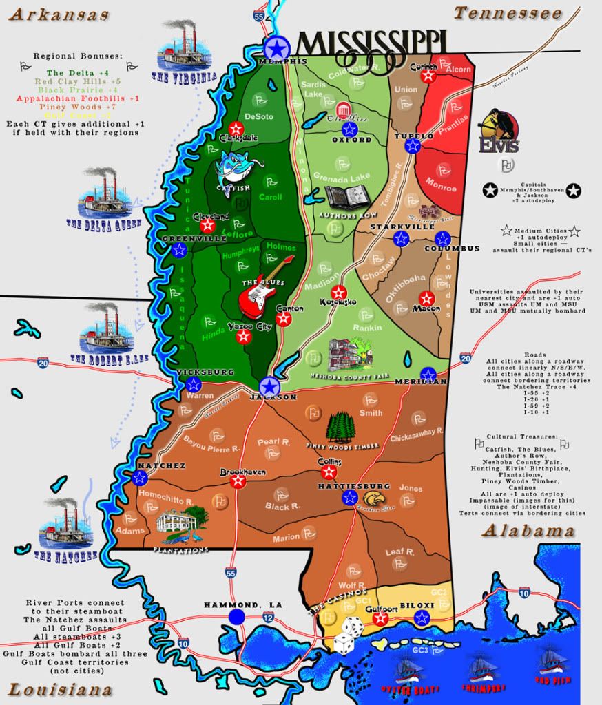
Actually, you can get the height down to 1000px if you just remove a bit from the upper edge, like this:
[bigimg]http://img851.imageshack.us/img851/2999/missx.jpg[/bigimg]
Although you could cut the height down even more by moving the title to the upper left corner and moving the stuff in the upper left corner down a bit.
Re: Mississippi Magnolia State Map
Posted: Sun Mar 11, 2012 2:05 pm
by VicFontaine
Perhaps. Once we get everything on the map and the legend cleaned up, it may work nicely. We'll give it a whirl. Thanks, ND!
Re: Mississippi Magnolia State Map
Posted: Mon Mar 12, 2012 6:30 pm
by RjBeals
[bigimg]http://i1154.photobucket.com/albums/p537/vicfontaine1/UPDATE2.jpg[/bigimg]
love the font & style of MISSISSIPPI title.
it's very hard to read the small text on the right side of the map. Increase font size, and maybe style.
Yellow Gulf Coast bonus font is almost impossible to see on my monitor. Either darken the yellow or add a dark glow.
I like your river boat symbols, but it's very hard to read the titles under them
I would add shades of colors to the surrounding non-playable states instead of white/gray.
Speaking of color - the overall color pallet of the map could use some fiddling with. green/tan/red/orange - does this mean something? If not, I would experiment with some better color combinations.
Really like the icons scattered throughout.
Highways look good, although I would increase the size of them, maybe a pixel or 2 so they stand out a bit more
Your Tennessee/Arkansas border way up top looks messy with the overlap of the river and border. It's okay to cheat a little with natural borders so its visually more appealing. Maybe take out the black border and just leave the river.
Re: Mississippi Magnolia State Map
Posted: Mon Mar 12, 2012 7:08 pm
by natty dread
In general, there's way too many fonts on the image.
Re: Mississippi Magnolia State Map
Posted: Mon Mar 12, 2012 7:14 pm
by VicFontaine
natty dread wrote:In general, there's way too many fonts on the image.
Because there are a myriad of bonuses, the fonts correspond to particular bonuses. Some of them certainly need tweaking, but the number of fonts really isn't a problem when you understand they make the bonuses easier to identify.
Re: Mississippi Magnolia State Map
Posted: Mon Mar 12, 2012 7:35 pm
by WILLIAMS5232
the only fonts i see that need changing are those boat names. i do think the bonuses and legend needs to be larger. you have plenty of room to do that so it shouldn't be a problem.
also, the colors could be better as far as in sync with the geography. ( green = pine belt, a shade of white = cotton belt, etc... )
some other items you may or may not care to use;
walter anderson art
emerald mound
petrified forest
camp shelby
Re: Mississippi Magnolia State Map
Posted: Mon Mar 12, 2012 8:57 pm
by VicFontaine
WILLIAMS5232 wrote:the only fonts i see that need changing are those boat names. i do think the bonuses and legend needs to be larger. you have plenty of room to do that so it shouldn't be a problem.
also, the colors could be better as far as in sync with the geography. ( green = pine belt, a shade of white = cotton belt, etc... )
some other items you may or may not care to use;
walter anderson art
emerald mound
petrified forest
camp shelby
Man after my CC die I see. INDEED! Talked to someone about Camp Shelby today. The military is a major cultural part of Mississippi. Always has been. I really wanted to include it somehow, but I don't think we could. Exact same thing with the Mound and with the Petrified Forest. We have discussed finding a good pic of the mound and making it a ghost image for Piney Woods region or a place like that (to aid the colorblind in IDing regional bonuses).
All these other things mentioned by you and others will be changed/tweaked.
Re: Mississippi Magnolia State Map
Posted: Mon Mar 19, 2012 9:21 pm
by Industrial Helix
This map has a nice feel to it, and its a part of the world not really represented well on CC, so moved.
Re: Mississippi Magnolia State Map
Posted: Mon Mar 19, 2012 10:04 pm
by VicFontaine
Industrial Helix wrote:This map has a nice feel to it, and its a part of the world not really represented well on CC, so moved.
Very glad you like it. Thanks for the kind words. Thanks again, everyone, for your patience as we await the Mighty Designer's return to the States to his magical dungeon where he speaks incantations and I post them for you to critique.

Re: Mississippi Magnolia State Map
Posted: Wed Mar 21, 2012 9:20 pm
by army of nobunaga
Congratz man.. I think it needs some gameplay work, but a lot of weaker gameplay maps made it through in the last 4 months when I was gone.
Cheers and when it hits gameplay Ill chime in more. looks like a winner so far even though its an evil evil state.
Re: Mississippi Magnolia State Map
Posted: Wed Mar 21, 2012 9:24 pm
by VicFontaine
army of nobunaga wrote:Congratz man.. I think it needs some gameplay work, but a lot of weaker gameplay maps made it through in the last 4 months when I was gone.
We aim to please. Thank you! (Yes, it does need some work. We're on "holiday hiatus" for another 2 1/2 weeks. Then Designer returns and he starts the magic again.)
army of nobunaga wrote:Cheers and when it hits gameplay Ill chime in more. looks like a winner so far even though its an evil evil state.
lol. It's a great place with a rich history. There is no state in the Union without a dark past, and every state in the Union has contributed much to human culture and beauty. Mississippi has a unique and well-known combination of both.
Re: Mississippi Magnolia State Map
Posted: Fri Mar 23, 2012 8:03 pm
by ViperOverLord
Glad to see this baby finally moved to the drafting room.
Re: Mississippi Magnolia State Map
Posted: Fri Mar 23, 2012 9:05 pm
by VicFontaine
ViperOverLord wrote:Glad to see this baby finally moved to the drafting room.
May she grow up quickly.

Re: Mississippi Magnolia State Map
Posted: Thu Apr 12, 2012 7:10 pm
by VicFontaine
Thanks for your patience, everyone.
The Designer is back from his 6 week vacation; we're working on some of the changes suggested in the last couple pages of the thread. A visual update will follow.
Thanks again.
Re: Mississippi Magnolia State Map
Posted: Thu Apr 12, 2012 9:50 pm
by VicFontaine
UPDATE AS OF APRIL 17, 2012: UPDATE #3
Map Name: Mississippi Magnolia
Mapmaker(s): [player]Vicfontaine[/player], "Deep Throat" Game Designer wants to be anonymous for now! lol
 Number of Territories:
 78
Special Features: multi-level bonuses (multiple regions, autodeploys, additional bonuses within regions, etc.), culture-specific to Mississippi
What Makes This Map Worthy of Being Made: There are no unique Deep South (USA) maps and this one provides that as well as detail into some Mississippi history; gameplay is easy but multi-dimensional with bonuses, attacks, defensive positions, etc.
UPDATE AS OF APRIL 17, 2012.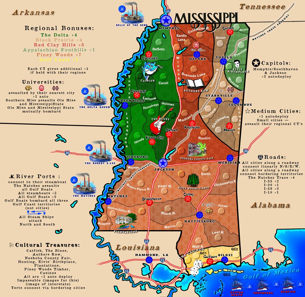
WHAT STILL MUST BE DONE:
1) Continue cleaning fonts
2) Move CT's and other images to maximize map clarity
3) Add impassable images; add attack route-lines for Steamboats
4) Add a few non-gameplay important images (e.g., entrance to Natchez Trace sign; Magnolia bloom)
5) Add ghosted images in the surrounding states. These will be very faint and aesthetically terrific, matching the State's history.
6) The possibility of an objective win: I like this. Don't know what it would be, but perhaps holding the Universities or all the Cultural treasures, plus the Capitol of Jackson.
(Older Version:)
(update #2)
ORIGINALS:
[bigimg]http://i1154.photobucket.com/albums/p537/vicfontaine1/ZoomAJPG.jpg[/bigimg]
[bigimg]http://i1154.photobucket.com/albums/p537/vicfontaine1/ZoomBJPG.png[/bigimg]
I didn't include an objective win, but would include one if this gets past the melting pot.
The territories are created by the infrastructure (Interstates, state highways, and the historic "Natchez Trace" roadway). The map includes unique cultural icons of Mississippi (history, major tourist attractions), and bonuses are plenty and varied and are based on cultural treasures, waterways, ecological regions, and major, medium, and small cities. Attack routes are "whatever is adjacent to" with, again, the roads serving as dividing lines.
Universities (Ole Miss, Mississippi State [MSU], University of Southern Mississippi [USM] are accessed via their adjoining cities (so: Oxford gets to Ole Miss, Starkville gets to MSU, and Hattiesburg gets to USM).
Would enjoy some feedback, and would love to see such a versatile map like this join the other terrific CC maps.
http://s1154.photobucket.com/albums/p537/vicfontaine1/?action=view¤t=MagnoliaMap.jpg
Re: Mississippi Magnolia State Map
Posted: Tue Apr 17, 2012 10:22 pm
by nolefan5311
I really like the new update, particularly you getting rid of a lot of the empty space in the legend areas.
Is there a reason why the legend symbols are different colors than the regions on the map, i.e. why the colors of the Capitals and Medium Cities aren't blue on the legend? I think that would clear up a little confusion.
You also might want to add the Interstate numbers somewhere along the roads in places other than outside the actual state. Having I-12 on there is also confusing.
Re: Mississippi Magnolia State Map
Posted: Tue Apr 17, 2012 11:17 pm
by Dukasaur
I don't spend enough time in the foundry; I never even saw this until today.
This map looks very nice. I like the colours and the symbology.
Some of the fonts are hard to read, especially under the boats.
Good job, Vic! I'm glad you finally got a map under way!

Re: Mississippi Magnolia State Map
Posted: Wed Apr 18, 2012 8:48 am
by mountain1024
Hi guys, thanks for a good looking future map. I have a problem with its size though - it barely fits on my laptop screen. Could you for instance fit all the map legend on one side to make it fit on smaller screens? Also I agree about the readability of smaller fonts.
Good job, looking forward for the beta.
Re: Mississippi Magnolia State Map
Posted: Wed Apr 18, 2012 9:52 am
by VicFontaine
nolefan5311 wrote:I really like the new update, particularly you getting rid of a lot of the empty space in the legend areas.
Yep.
nolefan5311 wrote:Is there a reason why the legend symbols are different colors than the regions on the map, i.e. why the colors of the Capitals and Medium Cities aren't blue on the legend? I think that would clear up a little confusion.
No. And I agree. It'll be done in one of the future updates, just not sure which one.
nolefan5311 wrote:You also might want to add the Interstate numbers somewhere along the roads in places other than outside the actual state. Having I-12 on there is also confusing.
We're concerned with cluttering it unnecessarily. Having the I-XX at both northern and southern, or eastern and western termini would be sufficient, I think, rather than in the interior of the map. Good eye, though; it's something we, too, noticed.
Re: Mississippi Magnolia State Map
Posted: Wed Apr 18, 2012 9:53 am
by VicFontaine
mountain1024 wrote:Hi guys, thanks for a good looking future map. I have a problem with its size though - it barely fits on my laptop screen. Could you for instance fit all the map legend on one side to make it fit on smaller screens? Also I agree about the readability of smaller fonts.
Size: it's a constant discussion. The map will definitely need supersizing. That doesn't mean it can't be continually tweaked to find the perfect fit. We'll keep working on it.
Readable fonts: it's also a constant discussion. Again, more tweaking will come.
mountain1024 wrote:Good job, looking forward for the beta.
Re: Mississippi Magnolia State Map
Posted: Wed Apr 18, 2012 10:56 pm
by army of nobunaga
I like the bigger than life southern images like the catfish and guitar.. It gives it a sort of cartoony doodle earth feel.. I like that... please do not change it.
Colors looking good too.