Page 2 of 3
Re: The Cold War (Global Map)
Posted: Sat Jan 01, 2011 1:44 pm
by Teflon Kris
Clarification Update:
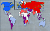
[bigimg]http://i480.photobucket.com/albums/rr162/teflonkris1/ColdWarv8.png[/bigimg]
Hopefully this gives a clear idea of gameplay? Or, it will once a Europe inset is done?
[Losing conditions explanation to be added.]
Below is a basic idea for the kind of distorted map we may need to develop to focus on the southern hemisphere and fit everything in. The bent screen seemed to look better than a flat distorted map somehow. It would be tempting not to use New Zealand for more space.
[bigimg]http://i480.photobucket.com/albums/rr162/teflonkris1/DistortedWorld-Condensed.png[/bigimg]
Re: The Cold War (Global Map)
Posted: Sat Jan 01, 2011 2:15 pm
by Industrial Helix
I'm thinking that we should use the N. Atlantic for the Europe inset and maybe use the inset to cover the Middle east as well. We're really going to have to distort the map to make this one work, I think. But really, look at the original Risk maps, they're quite distorted as well to make things playable. Plus, the inset can cover up some of Europe on the map, giving us more room.
So Middle East needs to be stretched and Caribbean/Central America needs it as well. Africa fits well, but the West coast is a problem.
We also need territory names.
I think skipping the regional bonuses would be a good thing... the real bonuses are coming from winning the conflicts, not necessarily holding a geographical area, Cuba for example.
In Indochina... what about adding Thailand to Indochina and moving the India border east. This eliminates Burma, but meh.
The seas... what about they can only be attacked in the areas with the arrows and can attack conflict areas? That way Mozambique can't win and then invade Mexico.
Nuke War... what about no killer neutral and losing condition if held? I rather like that idea because it makes Nuke War a possibility but an undesirable.
Something like Japan can be moved East and enlargened, this would also give korea some room to be enlargened as well.
And lastly I'm thinking color codings might be better than symbols because it reduces the clutter and gives us room to fit numbers and names.
Re: The Cold War (Global Map)
Posted: Sat Jan 01, 2011 4:48 pm
by Teflon Kris
Industrial Helix wrote:I'm thinking that we should use the N. Atlantic for the Europe inset and maybe use the inset to cover the Middle east as well.
Yeah, I was thinking about that for an inset spot, although it leaves Iceland as a problem (the inset would cover Iceland but Iceland would then make the inset larger than necessary).
We're really going to have to distort the map to make this one work, I think. But really, look at the original Risk maps, they're quite distorted as well to make things playable. Plus, the inset can cover up some of Europe on the map, giving us more room.
I agree, there is room for a certain degree of distortion, although it may look wierd if distortion strays too far from the two 'traditional' styles of world map. Working between those styles is no problem, but once we get to the extent we have I am wondering whether the distorted map would need have some graphical feature such as an old-skool TV/computer screen style. The added curvature of old-skool screens gives licence for more distortion still looking cool. Maybe? Not sure if I have explained that right.
So Middle East needs to be stretched and Caribbean/Central America needs it as well. Africa fits well, but the West coast is a problem.
A stretched arabian peninsula would be cool, but how about palestine, part of the inset or part of the stretched peninsula? Including in the inset would, like the Iceland problem, mean the inset would need to be bigger. I've already meddled with central america but agree it could do with more expanding. I expanded south america but perhaps it doesn't need as much as it has?
We also need territory names.
Yeah, I left this as things were changing from diagram to diagram but now its time for them. Any ideas for how to name the northern and southern parts of the Eastern Bloc?
I think skipping the regional bonuses would be a good thing... the real bonuses are coming from winning the conflicts, not necessarily holding a geographical area, Cuba for example.
It will save space too.
In Indochina... what about adding Thailand to Indochina and moving the India border east. This eliminates Burma, but meh.
This kinda makes sense.
The seas... what about they can only be attacked in the areas with the arrows and can attack conflict areas? That way Mozambique can't win and then invade Mexico.
I wasn't sure if my diagram would make it clear what the seas can attack.
And I was also thinking about which regions should be able to attack the seas ... only problems with limiting to the superpowers are: (a) getting around the map at the beginning of the game (which can be partly solved by complex starting region combinations); and (b) we would possibly want a few regions like Cuba to be able to attack out as well as be attacked? Such things can be sorted later anyhow as they wont make much odds to the layout (just a little extra space in the legend).
Nuke War... what about no killer neutral and losing condition if held? I rather like that idea because it makes Nuke War a possibility but an undesirable.
I like this idea, although I also like the killer neutral idea, and having to hold a non-commander region to stay alive. Just wondering if there could be 2 features - Nuke War and Airborne War? If we stuck with just your idea, the auto-deploys on the commanders would be awkward as players would most likely want to reinforce them elsewhere (although this can be interesting tactically, such as in Pelo War).
The Xmas map is a good example of a killer neutral being able to bombard regions required to eliminate an opponent. Although holding the 25th is not a losing condition, a failed kill on the killer neutral is potentially fatal to the player attempting it as it allows an opponent to then take the 25th cheaply, finish the elimination off and potentially make additional progress / eliminations.
Anyway, either way, or both ways, we can discuss further and decide without having to make major layout changes.
Something like Japan can be moved East and enlargened, this would also give korea some room to be enlargened as well.
Yeah, Japan, Korea and Taiwan can get the treatment.
And lastly I'm thinking color codings might be better than symbols because it reduces the clutter and gives us room to fit numbers and names.
I think you're right here, although if there were room for symbols I think it would be more appealing graphically, especially as we could then have earthy colours for the land. But, you're right, we can't afford the space in most areas.
Also, what do you think to the right-left bonus cancellation idea (I think it was Sully's above) - bonuses are cancelled-out by holding both red and blue regions (although I think we should ensure conflict region bonuses aren't affected by this)?
Also, should the bonuses be dependant on holding a super-power as opposed to the UN seat? Or maybe both? This would make it more possible for a player to make a raid through the narrow routes to a super-power, which may then finish when coming up to a partly stacked 'commander' which can then hit back next round?
Re: The Cold War (Global Map)
Posted: Sun Jan 02, 2011 10:18 am
by Teflon Kris
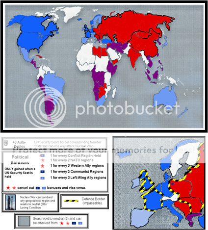
I've had further thoughts on the question of 'clutter':
1. Perhaps we could do away with the arrows (in the legend "Superpowers can one-way attack through defence barriers")?
2. Instead of symbols, have army shapes instead of army circles (army stars), or coloured army circles?
And further thought on where can be attacked from the seas:
"Seas can one-way assault conflict regions" (thus focussing on these regions as per the real cold war - players would have even more reason to defend them more than the 'ally' regions (and politically neutral regions).
Re: The Cold War (Global Map)
Posted: Sun Jan 02, 2011 10:48 am
by Industrial Helix
Yeah, I think we can do away with the arrows. Though for the army circles, I'm hoping we can do away with them totally.
Re: The Cold War (Global Map)
Posted: Tue Feb 01, 2011 7:07 pm
by Teflon Kris
So forry the extreme lack of update - just getting my life fixed, or at least bandaged, and I'll be back for this map and tournament business.
Re: The Cold War (Global Map)
Posted: Tue Feb 01, 2011 7:36 pm
by theBastard
I must repeat myself, but why you can not use Warsaw pact for communist (and sort communist countries to members and others) when you have NATO in the map?
the second question, why you did Nepal as communist and India as Left wing ally?
Re: The Cold War (Global Map)
Posted: Sat Feb 05, 2011 8:37 am
by Teflon Kris
theBastard wrote:I must repeat myself, but why you can not use Warsaw pact for communist (and sort communist countries to members and others) when you have NATO in the map?
the second question, why you did Nepal as communist and India as Left wing ally?
If its ok, I will come back to your points.
First and foremost I think the overall layout, and in particularm, the Europe inset, is the primary concern.
Fiddling about with the coloured layout, it looks difficult to enlarge very much in the north atlantic space:

There are various alternatives:
1. Not using Iceland at all - then the Inset need not go so far North.
2. Large map status
3(a). Put the inset elsewhere e (e.g. as per the more distorted, curved world map above).

3(b). Have overall graphics system in three TV/Monitor-screen style sections, as follows (maybe a bit along the lines of the curved example just above):
An overall world map
Another small Europe (inset) map below
Another screen with bonus information etc etc.
Something like this, but monitor-screened-up? :
The Monitor-screen style would add to the sense of players being a super-power world leader in a control centre, along the lines of that 'War Games' film.
Re: The Cold War (Global Map)
Posted: Sat Feb 05, 2011 4:42 pm
by Industrial Helix
Skip iceland... and I think this map could benefit from the large map status. The Cold War world was complicated and large, I think we'll need the space to pull it off.
Re: The Cold War (Global Map)
Posted: Sat Feb 05, 2011 5:01 pm
by theBastard
how you can skip the Iceland? it was founder of NATO. I like the first big image (with enlarge Europe in its place) and also to go with "supersize"...
Re: The Cold War (Global Map)
Posted: Sat Feb 05, 2011 11:12 pm
by Industrial Helix
Bah, fine, keep it

I could go either way. I wish I could htink of a snarky way to tie this into this post... but did you know that the American's and British occupied Iceland during WWII? There were like Marines and everything there, despite Icelandic pleas to be neutral.
Re: The Cold War (Global Map)
Posted: Sun Feb 06, 2011 3:08 am
by theBastard
did not know this. was it ccupation or Iceland gived his land for US/Brittish bases?
btw, was/is there any corner of world which Brittish/US did/are not occupied? lol
Re: The Cold War (Global Map)
Posted: Sun Feb 06, 2011 6:35 am
by Teflon Kris
Another question while we are looking at overall layout, is whether to include New Zealand? Without New Zealand, gameplay would be little different and the right-hand edge of the map can be narrowed a touch. I don't ever seem to remember New Zealand being much of a player in the Cold War?
Re: The Cold War (Global Map)
Posted: Sun Feb 06, 2011 7:02 am
by theBastard
maybe New Zealand could stay where it is now. or you need more cut the map? and New Zealand has nothing to do with NATO (foundation, membership)...
Re: The Cold War (Global Map)
Posted: Sun Feb 06, 2011 10:12 am
by Teflon Kris
theBastard wrote:maybe New Zealand could stay where it is now. or you need more cut the map? and New Zealand has nothing to do with NATO (foundation, membership)...
Yeah, that's the idea, to create some space - with New Zealand in the map there is a fair bit on unnecessary eastern pacific space.
And yeah, New Zealand as a non-member of NATO would just be a light blue, western-aligned region. If New Zealand were cut, Australia could be spilt if any extra western-aligned regions were needed for balance.
Re: The Cold War (Global Map)
Posted: Sun Feb 06, 2011 11:06 am
by Industrial Helix
The British invaded Reykjavik because they feared the Nazis would do the same and have an air/naval base behind Britain, which would defeat Britain completely. This was right after Norway and Denmark. Then the USA put the 1st Marines in as a replacement to free up the British so they could fight the Germans.
Anyway... wasn't New Zealand a founding member of Seato? Not that Seato ever did anything.... Also, Australia was a big contributor of men during the Vietnam War, I wonder if New Zealand was the same.
Re: The Cold War (Global Map)
Posted: Sun Feb 06, 2011 2:20 pm
by Teflon Kris
Going back to the Europe inset - it could be stretched west, and slightly south - doesn't matter too much if it covers parts of the US/Canada east coast in my mind.
Re: The Cold War (Global Map)
Posted: Sun Feb 06, 2011 3:50 pm
by Industrial Helix
I wonder if you could tilt Europe a little and gain some space.
Re: The Cold War (Global Map)
Posted: Sun Feb 06, 2011 4:55 pm
by Teflon Kris
Industrial Helix wrote:I wonder if you could tilt Europe a little and gain some space.
I'm thinking perhaps the top could be chopped off - might look odd though - will post 2moz
Re: The Cold War (Global Map)
Posted: Tue Feb 08, 2011 11:48 pm
by Baron Von PWN
What about a polar attack route? during the cold war there were major fears of Soviet attack across the north pole.
Re: The Cold War (Global Map)
Posted: Tue Mar 01, 2011 6:26 pm
by Teflon Kris
Update coming soon

Re: The Cold War (Global Map)
Posted: Tue Mar 01, 2011 9:56 pm
by Victor Sullivan
Good to hear

Re: The Cold War (Global Map)
Posted: Thu Mar 10, 2011 3:46 pm
by Teflon Kris
Currently working on a warped coloured version - thanks for your patience
The Cold War (Global Map) - Layout Tinkering
Posted: Sat Mar 12, 2011 9:52 am
by Teflon Kris
Still tinkering with layout.
This has some stretches and curve bends involved to increase the relative sizes of Europe, Latin America, Africa and Japan (& NZ deleted):
[bigimg]http://i480.photobucket.com/albums/rr162/teflonkris1/CWarv15.jpg[/bigimg]
Obviously more to do making the shapes nice once the relative sizes are sorted.
(Image also updated on 1st post)
Re: The Cold War (Global Map)
Posted: Sat Mar 12, 2011 10:03 am
by natty dread
Can't see image.