Oceania Map!-CC MAP UP!
Moderator: Cartographers
Forum rules
Please read the Community Guidelines before posting.
Please read the Community Guidelines before posting.
-
Bad Speler

- Posts: 1027
- Joined: Fri Jun 02, 2006 8:16 pm
- Gender: Male
- Location: Ottawa
- Contact:


-
spinwizard

- Posts: 5016
- Joined: Sun Dec 10, 2006 9:52 am

-
spinwizard
- Posts: 5016
- Joined: Sun Dec 10, 2006 9:52 am
I've attempted Oceania, it's just not viable as a map in its full state. I suggest cutting it down to include just the islands North-East of Australia and losing all major land mass. Or you could cut the majority of islands out and crop it around that blue line to the East of New Zealand and include everything West of that line.
As for all those countries qwert listed, they are generally considered part of Oceania by most maps. Some use from the Papua New Guinea border and to the East, but that seems to be a minority.
I suggest cropping the map some more and see where you go from there.
As for all those countries qwert listed, they are generally considered part of Oceania by most maps. Some use from the Papua New Guinea border and to the East, but that seems to be a minority.
I suggest cropping the map some more and see where you go from there.
It doesn't belong to Australia, but quite a few sites have it listed as part of Oceania.
http://en.wikipedia.org/wiki/Oceania
Just look at that link. Indonesia can be part of Oceania or it can be excluded, it depends on your source and your own opinion.
http://en.wikipedia.org/wiki/Oceania
Just look at that link. Indonesia can be part of Oceania or it can be excluded, it depends on your source and your own opinion.


-
spinwizard
- Posts: 5016
- Joined: Sun Dec 10, 2006 9:52 am
-
spinwizard
- Posts: 5016
- Joined: Sun Dec 10, 2006 9:52 am
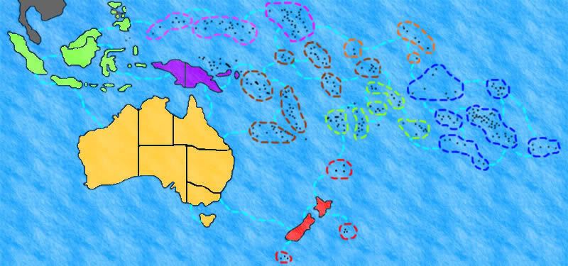
It seems like a bit of a mess of lines at the moment. I appreciate Oceania is probably one of the hardest things to make a map of, it's just not looking great right now.
Beyond cropping the image down like I suggested before, I don't see how this can be a good map. All those islands just make the map cluttered and confusing. I can't see where you will be able to fit in names and army shadows for a lot of those territories.
Beyond cropping the image down like I suggested before, I don't see how this can be a good map. All those islands just make the map cluttered and confusing. I can't see where you will be able to fit in names and army shadows for a lot of those territories.
-
spinwizard
- Posts: 5016
- Joined: Sun Dec 10, 2006 9:52 am
-
spinwizard
- Posts: 5016
- Joined: Sun Dec 10, 2006 9:52 am
qwert wrote:I give up, its sems that old coalition(Keyoky and Teya) again atack my opinion, and again these guys must be right in all circumstances.
You attacked keyogi first as usual then blame everyone else.
And seriously? what does it matter? Some people think indonesia is part of oceania some people dont. Spinwizard needs the landmass, so he is including it.
Qwert I think you will find that you are the one that thinks your opinion is right. keyogi said to you originally that indonesia is often included and you take this as an attack? I say who cares and you take that as an attack? Get over yourself. Everyone is entitled to their own opinion. You think Indonesia is not part of oceania, Keyogi thinks it is and I say who cares. It doesnt matter if we all have different opinions because they are all vailid. No one is right or wrong.
-
Lone.prophet
- Posts: 1467
- Joined: Thu Oct 12, 2006 4:37 pm
- Location: Your basement Muahaha

-
spinwizard
- Posts: 5016
- Joined: Sun Dec 10, 2006 9:52 am

KEYOGI wrote:As for all those countries qwert listed, they are generally considered part of Oceania by most maps. Some use from the Papua New Guinea border and to the East, but that seems to be a minority.
qwert wrote:I dont know wher you find map where Indonesia belong to AUTRALIA AND OCEANIA?
KEYOGI wrote:http://en.wikipedia.org/wiki/Oceania
Just look at that link. Indonesia can be part of Oceania or it can be excluded, it depends on your source and your own opinion.
qwert wrote:I give up, its sems that old coalition(Keyoky and Teya) again atack my opinion, and again these guys must be right in all circumstances.
How have I attacked you? I said Indonesia can be considered part of Oceania or it can be excluded.
-
spinwizard
- Posts: 5016
- Joined: Sun Dec 10, 2006 9:52 am
Now, back on topic.
What program are you using spinwizard?
Those army shadows look tiny, what size are they?
If you tone down the sea texture, the clarity of the map may improve. Then you may be able to tackle the problem of how to represent the islands. Perhaps a faint colour in the spaces you have marked out with a solid border? I'm not really sure, you'll just have to play around with it to find something that looks best.