Page 20 of 23
Posted: Sat Jul 14, 2007 11:43 am
by HighCommander540
edbeard wrote:I went through your XML. I did not find any problems. I do suggest you go through it yourself a few times just to be sure. One thing I did not do was enter the XML into the tester which would help you make sure you spelled the name of a territory the same way throughout the XML. You've probably already done it, but if not you need to do it.
A few graphics suggestions:
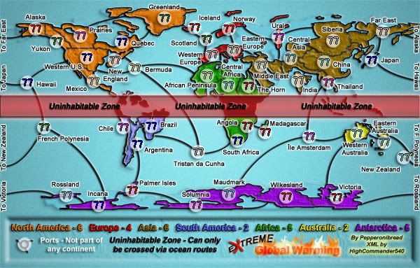
One thing that I found a problem with graphics-wise are a few borders, or non-borders. From Western US to New England if you glance quickly you'll think there is a border there. Maybe you can increase the gap a bit.
I'd say the same is true in Japan, but it's definitely more pronounced in the west us and New england area.
Also, maybe increase the size of the border between Praries and Quebec. the border is quite small and any confusion will be averted with a larger border. you probably could just increase the lower left area of Quebec to make this more clear.
Oh almost forgot, the lake or whatever it is in Siberia, just under the army circle. It looks like you were drawing borders in and the brush strayed off there.
Lol, the XML is good I triple checked it. It will be fine. All territories are in place and as long as they stay in the same place and on't change in size on either one of them it will be fine. If it does I will fix it when I get back I will only be gone for another 5 days at max.
Posted: Sat Jul 14, 2007 3:37 pm
by pepperonibread
HighCommander540 wrote:edbeard wrote:I went through your XML. I did not find any problems. I do suggest you go through it yourself a few times just to be sure. One thing I did not do was enter the XML into the tester which would help you make sure you spelled the name of a territory the same way throughout the XML. You've probably already done it, but if not you need to do it.
A few graphics suggestions:
One thing that I found a problem with graphics-wise are a few borders, or non-borders. From Western US to New England if you glance quickly you'll think there is a border there. Maybe you can increase the gap a bit.
I'd say the same is true in Japan, but it's definitely more pronounced in the west us and New england area.
Also, maybe increase the size of the border between Praries and Quebec. the border is quite small and any confusion will be averted with a larger border. you probably could just increase the lower left area of Quebec to make this more clear.
Oh almost forgot, the lake or whatever it is in Siberia, just under the army circle. It looks like you were drawing borders in and the brush strayed off there.
Lol, the XML is good I triple checked it. It will be fine. All territories are in place and as long as they stay in the same place and on't change in size on either one of them it will be fine. If it does I will fix it when I get back I will only be gone for another 5 days at max.
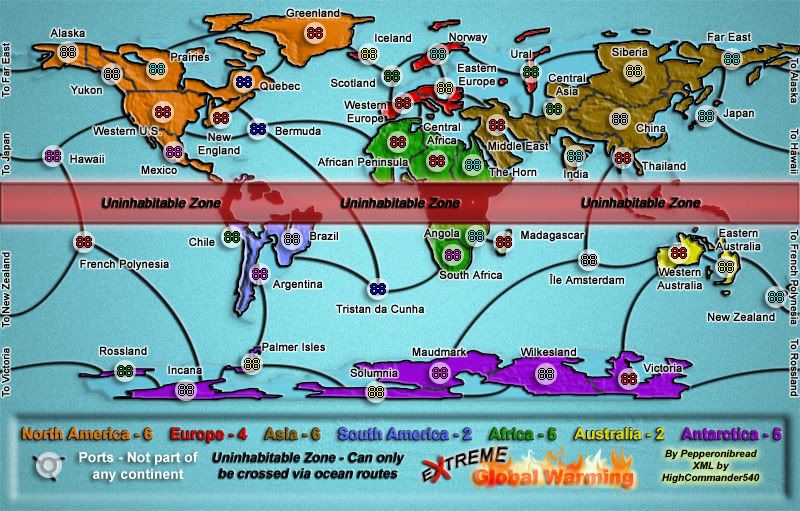
Yeah, I think the XML is fine now, after HighCommander emailed it to me I only changed one or two things. Regarding the borders, I enlarged all of them and adjusted some textures in this update right here:
Large:

Large w/ XML:
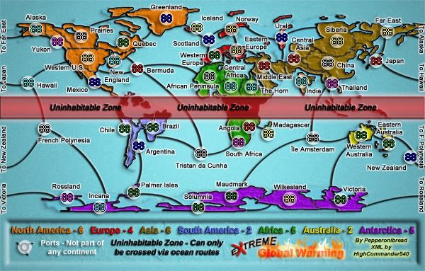
Small:

Small w/ XML:
Posted: Sat Jul 14, 2007 5:03 pm
by Xyl
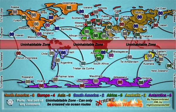
Why do the 5's in the legend look like 6's? You can tell the difference if you compare them to the actual 6's, but at a glance it's confusing. Maybe less shadow, or a different font, or something, would make it clearer?
Posted: Sat Jul 14, 2007 5:26 pm
by Bad Speler
When the armys are on the army shadows, it is hard to tell whether New Zealand is part of the Austrailia continent or if it is a port because the number obscures the land. Just move the army shadow a bit to the left so the land is visible.
Posted: Sat Jul 14, 2007 5:40 pm
by Kawg of war
jnd94 wrote:If this is global warming, shouldnt Antarctica be smaller? Not bigger, thats for sure.
i think what happened was an ice age that froze the ocean around antarctica and shazzam, larger continent
Posted: Sat Jul 14, 2007 9:58 pm
by pepperonibread
Bad Speler wrote:When the armys are on the army shadows, it is hard to tell whether New Zealand is part of the Austrailia continent or if it is a port because the number obscures the land. Just move the army shadow a bit to the left so the land is visible.
Xyl wrote:Why do the 5's in the legend look like 6's? You can tell the difference if you compare them to the actual 6's, but at a glance it's confusing. Maybe less shadow, or a different font, or something, would make it clearer?
Thanks guys.
Posted: Mon Jul 16, 2007 10:49 am
by pepperonibread
New update:
Large:
Large w/ XML:

Small:
Small w/ XML:
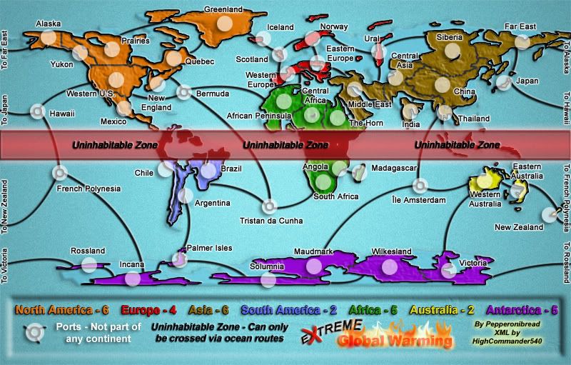
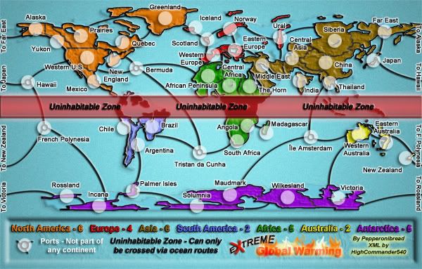
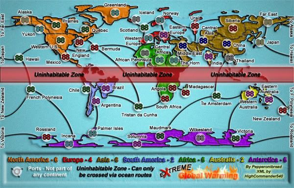
Just two changes, I moved the New Zealand army circle a bit and made the continent bonuses on the legend easier to read.
Posted: Fri Jul 20, 2007 1:31 pm
by wrightfan123
Wade, I have been off at baseball camp all flipping week. I will be off at band camp all next week. If this map isn't fricking quenched when I get back, bad things will happen.
Posted: Sat Jul 21, 2007 12:17 am
by HighCommander540
Hey, dude I am back home now...So do you need me to do anything?
Posted: Sat Jul 21, 2007 8:11 am
by pepperonibread
HighCommander540 wrote:Hey, dude I am back home now...So do you need me to do anything?
No, it's all fine. People just asked me to move the New Zealand army circles a bit, so I shifted the coordinates accordingly.
Posted: Sat Jul 21, 2007 11:30 am
by HighCommander540
Ok, sounds good.
Finish Him... LOL
Posted: Tue Jul 24, 2007 9:30 am
by Solus
I want to play on this soon... How long do you estimate until it's ready?

Re: Finish Him... LOL
Posted: Tue Jul 24, 2007 12:34 pm
by pepperonibread
Solus wrote:I want to play on this soon... How long do you estimate until it's ready?
Well, no one has suggested any improvements in a while, so shouldn't be long unless Andy or Keyogi spots something.
Posted: Tue Jul 24, 2007 5:56 pm
by edbeard
that top left portion of new england will probably still confuse some people. I can understand that you can't cross to western US from there but I'll bet others will think those are connected.
On the large map, you still have the line on the bottom of the Siberia army circle. I think it's supposed to be a dry bed of a lake or something? Whatever it is, it looks bad. It looks like you strayed with your brush and forgot to take it out.
Posted: Tue Jul 24, 2007 7:03 pm
by pepperonibread
edbeard wrote:that top left portion of new england will probably still confuse some people. I can understand that you can't cross to western US from there but I'll bet others will think those are connected.
Concerning this, I believe I'm just going to add a sea route there. When I began this map, I was still learning Photoshop and the way I created it before prevents me from erasing that black border and making a new one of the same size. It would look too out of place.
edbeard wrote:On the large map, you still have the line on the bottom of the Siberia army circle. I think it's supposed to be a dry bed of a lake or something? Whatever it is, it looks bad. It looks like you strayed with your brush and forgot to take it out.
When I first made the map, this area turned out to be below the minimum elevation for land areas (if that makes sense), so I gave it a black border. However, you have a valid point; I will erase it.
Posted: Tue Jul 24, 2007 8:32 pm
by pepperonibread
New update:
Large:

Large w/ XML:

Small:

Small w/ XML:
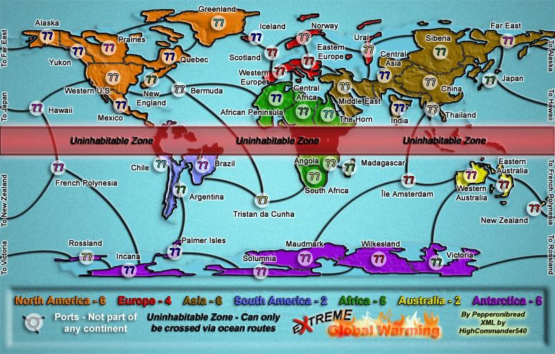
Added in sea route between N. England and Western U.S. and erased lake in Siberia. I also slightly moved the Siberia army circle on the large map and adjusted the XML accordingly.
Posted: Tue Jul 24, 2007 8:36 pm
by WidowMakers
pepperonibread wrote:edbeard wrote:that top left portion of new england will probably still confuse some people. I can understand that you can't cross to western US from there but I'll bet others will think those are connected.
I would just cut off the portion of land in new england that is around the great lakes (large and small map). Then for the small map just move the circle to the right and you should be set. If you think it will be too hard to erase the border and redraw it, just first erase teh border and land and then use the clone stamp tool to redraw the border from another similar border. I can help you out if you want.
WM
Posted: Tue Jul 24, 2007 8:48 pm
by edbeard
I'm going to be difficult here and I'm sorry for that.
I think the water route would be better placed on the lower left portion of New England so it connects to Western US just north of the other water route that connects to Bermuda.
This way the route can be seen easily on both the large and small versions of your map.
Posted: Tue Jul 24, 2007 9:46 pm
by pepperonibread
edbeard wrote:I'm going to be difficult here and I'm sorry for that.
I think the water route would be better placed on the lower left portion of New England so it connects to Western US just north of the other water route that connects to Bermuda.
This way the route can be seen easily on both the large and small versions of your map.
That's alright. Anyway, I'm thinking WidowMakers' idea would probably work better here.
Posted: Wed Jul 25, 2007 2:37 am
by insomniacdude
First time looking at the map. I'd move over or up the word Angola - or move the border with S. Africa down - to make sure everyone can see the border between it and South Africa (especially on the small map). I had no idea where it was at first, and was initially confused why one country had two titles.
Otherwise I like.
Posted: Thu Jul 26, 2007 1:26 pm
by pepperonibread
New Update:
Large:

Large w/ XML:
Small:
Small w/ XML:
New Junk:
-Widened gap between New England and Western U.S. (thanks for the tip, WidowMakers)
-Made border between Prairies and Quebec more noticeable
-Adjusted New England army circle
-Moved some stuff to make Angola-South Africa border more visible
-Slightly moved South Africa army circle (small map)
-Changed XML as needed
Here's the current XML, if anyone cares:
Extreme Global Warming XML
P.S.: 7's are cooler than 8's.
Posted: Thu Jul 26, 2007 5:08 pm
by reverend_kyle
I don't know if this has been mentioned and maybe its too late, but this map needs cleaned up majorly near alaska and greenland, and I 'm not a fan of the texture.
Posted: Thu Jul 26, 2007 6:03 pm
by pepperonibread
reverend_kyle wrote:I don't know if this has been mentioned and maybe its too late, but this map needs cleaned up majorly near alaska and greenland, and I'm not a fan of the texture.
What does "cleaned up" mean? I don't see anything wrong with these areas.
Posted: Thu Jul 26, 2007 7:59 pm
by wrightfan123
Wade, it's my birthday Saturday. quenching this thing would be a nice present. and just wanted2let u know im back and ready to help.
Posted: Thu Jul 26, 2007 8:57 pm
by pepperonibread
Hey, welcome back.