Wales [Quenched]
Moderator: Cartographers
Forum rules
Please read the Community Guidelines before posting.
Please read the Community Guidelines before posting.
-
LED ZEPPELINER
- Posts: 1088
- Joined: Tue Nov 25, 2008 10:09 pm
Re: Wales [FF] -> Final Version p1/15
i have been looking at this map for quite some time, and i cannot find anything wrong... i say quench it 
sailorseal wrote:My big boy banana was out the whole time
AndyDufresne wrote:Forever linked at the hip's-banana! (That sounds strange, don't quote me.)AndyDufresne wrote:Many Happy Bananas to everyone, lets party...with Bananas.
--Andy

Re: Wales [FF] -> Final Version p1/15
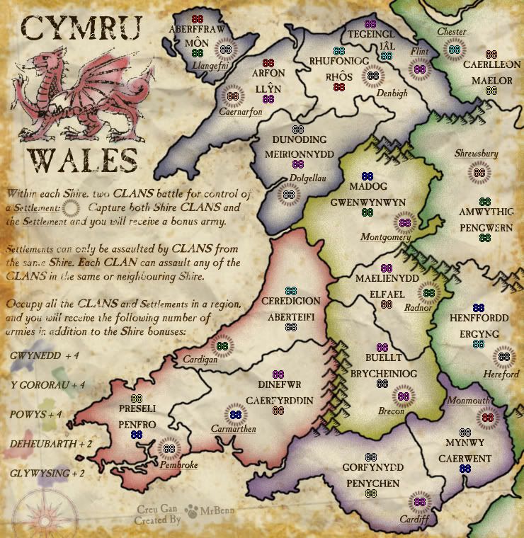
Here is my absolutely final update (I hope)... There are no changes to the small map, but I have made some minor tweaks on the large one... all the army numbers are exactly the same distance (3px) from the territory name. I've redrawn a tiny bit of border by the Ial number, and shifted those names to get it to fit properly.
Here's the XML with the adjusted coordinates: http://www.fileden.com/files/2009/1/9/2 ... XML_05.xml
Here is the small image: http://i275.photobucket.com/albums/jj32 ... les23S.jpg
Here is the large image: http://i275.photobucket.com/albums/jj32 ... les24L.jpg
Here are all the test images:
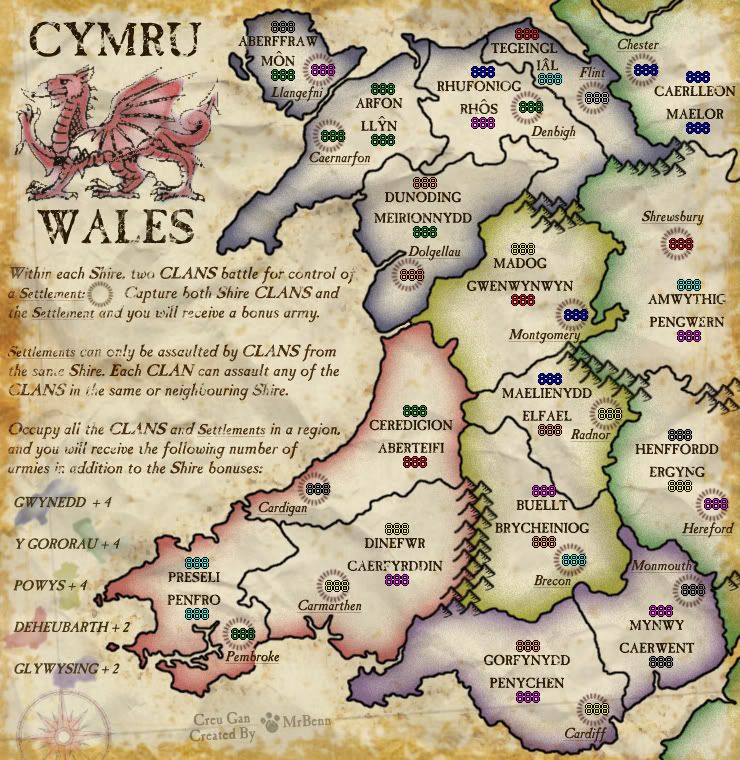
Here's the XML with the adjusted coordinates: http://www.fileden.com/files/2009/1/9/2 ... XML_05.xml
Here is the small image: http://i275.photobucket.com/albums/jj32 ... les23S.jpg
Here is the large image: http://i275.photobucket.com/albums/jj32 ... les24L.jpg
Here are all the test images:
- Click image to enlarge.
- Click image to enlarge.
- Click image to enlarge.

PB: 2661 | He's blue... If he were green he would die | No mod would be stupid enough to do that
-
LED ZEPPELINER
- Posts: 1088
- Joined: Tue Nov 25, 2008 10:09 pm
Re: Wales [FF, X] -> Finished at last? p1/16
ok, so i know you wanted this to be ur last update, but i am thinking that you should lessen the opacity on the borders, the actuall land is translucent, and looks like part of the paper behind, but the lines just look like theyre lying on top
Re: Wales [FF, X] -> Finished at last? p1/16
OK, I've just spent 5 mins playing around with the opacity of the borders, but it just makes them look more grey and lose definition. To get the background to show through, you have to turn the opacity quite low, and it just makes the lines look rubbish. Suggestion denied 
PB: 2661 | He's blue... If he were green he would die | No mod would be stupid enough to do that

Re: Wales [FF] -> Final Version p1/15
The next time you say that I'm going to find some nit-picky detail just to mess with you.MrBenn wrote:Here is my absolutely final update...

Re: Wales [FF, X] -> Finished at last? p1/16
I thought that's what the nit-picky coordinate shifting was for
PB: 2661 | He's blue... If he were green he would die | No mod would be stupid enough to do that
-
AndyDufresne

- Posts: 24935
- Joined: Fri Mar 03, 2006 8:22 pm
- Location: A Banana Palm in Zihuatanejo
- Contact:
Re: Wales [FF, X] -> Finished at last? p1/16
- Quenching
Conquer Club, enjoy!


-
Genghis Khant
- Posts: 867
- Joined: Fri Dec 01, 2006 3:02 am
- Gender: Male
- Location: Cymru
- Contact:
Re: Wales [Quenched]
Ardderchog! Diolch yn fawr i gymuned CC, ac yn enwedig i Mr Benn.
Cymru am byth.
Cymru am byth.
-
the.killing.44

- Posts: 4724
- Joined: Thu Oct 23, 2008 7:43 pm
- Gender: Male
- Location: now tell me what got two gums and knows how to spit rhymes
- Contact:
Re: Wales [Quenched]
Great!!!!!!
.44
.44
-
tlane
- Posts: 309
- Joined: Wed Oct 22, 2008 7:11 pm
- Gender: Male
- Location: NYC - sint maarten(sometimes)
Re: Wales [Quenched]
GReat JOB!!

Re: Wales [Quenched]
Excellent.
Cymru am byth. (Wales Forever!)
Thank you.
Wrex
Cymru am byth. (Wales Forever!)
Thank you.
Wrex
-
LED ZEPPELINER
- Posts: 1088
- Joined: Tue Nov 25, 2008 10:09 pm
Re: Wales [Quenched]
ive benn waiting so long, gåcias
Re: Wales [Quenched]
Huzzah!
Thanks to everybody for your help and support... Let's get the boat on the road
Thanks to everybody for your help and support... Let's get the boat on the road
PB: 2661 | He's blue... If he were green he would die | No mod would be stupid enough to do that

Re: Wales
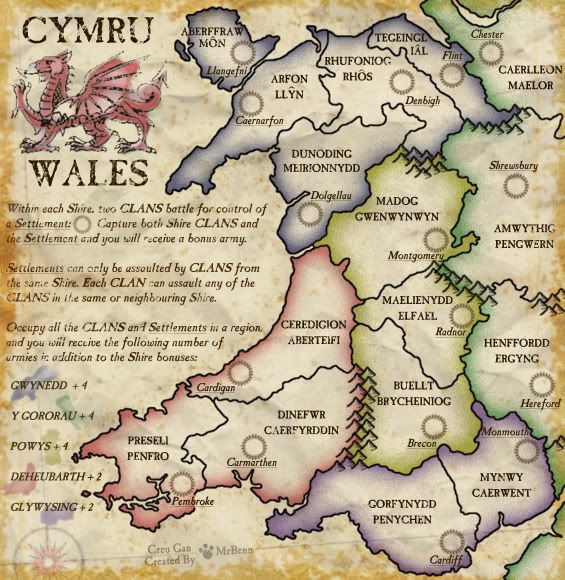
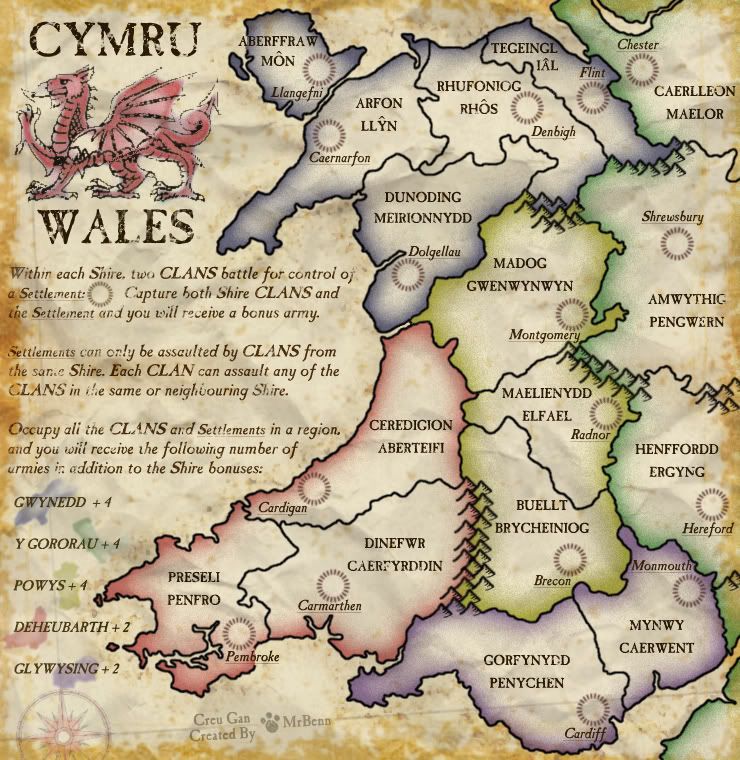
Great Britain = Landmass containing England, Scotland and Walesmultiplayertim wrote:Ireland is not part of Britian the term british isles bothers me enough but going as far to call Ireland British is too farMrBenn wrote:There are maps of the British Isles, Scotland and Ireland already in play, and I've got around to thinking, "why not have maps of England and Wales too?" If these 2 are done, then there will be a British version of WM's USA 6-pack suitable for tournaments etc.
Ireland = Landmass containing Northern Ireland and the Republic of Ireland
British isles = Great Britain + Ireland
The term British Isles is simply the geographical term for the two islands, it's a historical term and modern day politics have no bearing on it.
Mrbenn didn't say Ireland was part of Britain.
-
Genghis Khant
- Posts: 867
- Joined: Fri Dec 01, 2006 3:02 am
- Gender: Male
- Location: Cymru
- Contact:
Re: Wales [Quenched]
Why is it taking so long for this map to go live?
Re: Wales [Quenched]
It is the way of the world....
PB: 2661 | He's blue... If he were green he would die | No mod would be stupid enough to do that
-
sailorseal

- Posts: 2735
- Joined: Sun May 25, 2008 1:49 pm
- Gender: Male
- Location: conquerclub.com
Re: Wales [Quenched]
Just want to say great map! Nice job! Every day I check to see if it went live...
-
tlane
- Posts: 309
- Joined: Wed Oct 22, 2008 7:11 pm
- Gender: Male
- Location: NYC - sint maarten(sometimes)
Re: Wales [Quenched]
more like the way of walesMrBenn wrote:It is the way of the world....
this looks great
tlane
Re: Wales [Quenched]
Looks like we made it in the end!
Thanks to everybody for their support during the development of this map.
Thanks to everybody for their support during the development of this map.
PB: 2661 | He's blue... If he were green he would die | No mod would be stupid enough to do that

-
InsomniaRed

- Posts: 2246
- Joined: Sun Dec 30, 2007 2:58 am
- Gender: Female
- Location: In Nick's heart
Re: Wales [Beta]
Yes and it's making my brain hurtyeti_c wrote:Euch - you broke Bob, CM and the Drop Downs!!!
C.
- I will always love you Nick, Forever.

- I will always love you Nick, Forever.
Re: Wales [Beta]
I think it's the accent on the Y in Llyn.
I'll edit the XML now....
I'll edit the XML now....
PB: 2661 | He's blue... If he were green he would die | No mod would be stupid enough to do that
Re: Wales [Beta]
Updated XML - I've taken out the accented Y from Llyn, which might solve the problem?? PM sent to lackattack.
http://www.fileden.com/files/2009/1/9/2 ... XML_06.xml
http://www.fileden.com/files/2009/1/9/2 ... XML_06.xml
PB: 2661 | He's blue... If he were green he would die | No mod would be stupid enough to do that
Re: Wales [Beta]
It shows in your picture!!InsomniaRed wrote:Yes and it's making my brain hurtyeti_c wrote:Euch - you broke Bob, CM and the Drop Downs!!!
C.
C.

Highest score : 2297