
-griff
First Nations of South America!
Moderator: Cartographers
Forum rules
Please read the Community Guidelines before posting.
Please read the Community Guidelines before posting.

-
natty dread

- Posts: 12877
- Joined: Fri Feb 08, 2008 8:58 pm
- Location: just plain fucked


Re: First Nations of South America!
would be amazing if I could actually play this.. 
my refresh is getting tired..
my refresh is getting tired..

Re: First Nations of South America!
Tisha wrote:I like, that's why it's there
Beta Beta BetaArmy of GOD wrote:I don't get why the
Highest Rank: 26 Highest Score: 3480


Re: First Nations of South America!
I think it's live now! It's in the Game Finder list.
-
natty dread
- Posts: 12877
- Joined: Fri Feb 08, 2008 8:58 pm
- Location: just plain fucked
-
army of nobunaga

- Posts: 1989
- Joined: Sat Oct 13, 2007 10:06 pm
- Gender: Male
- Location: www.facebook.com/armyofnobu and Houston.
- Contact:
Re: First Nations of South America!
congratz on the next stage!
Maps Maps Maps!
Take part in this survey and possibly win an upgrade -->
https://docs.google.com/spreadsheet/emb ... OHRFZnc6MQ
Take part in this survey and possibly win an upgrade -->
https://docs.google.com/spreadsheet/emb ... OHRFZnc6MQ
Re: First Nations of South America!
like the map, love the colours and style, keep it up!
-
The Bison King

- Posts: 1957
- Joined: Thu Aug 27, 2009 5:06 pm
- Location: the Mid-Westeros
Re: First Nations of South America!
Digging this map hard.


Re: First Nations of South America!
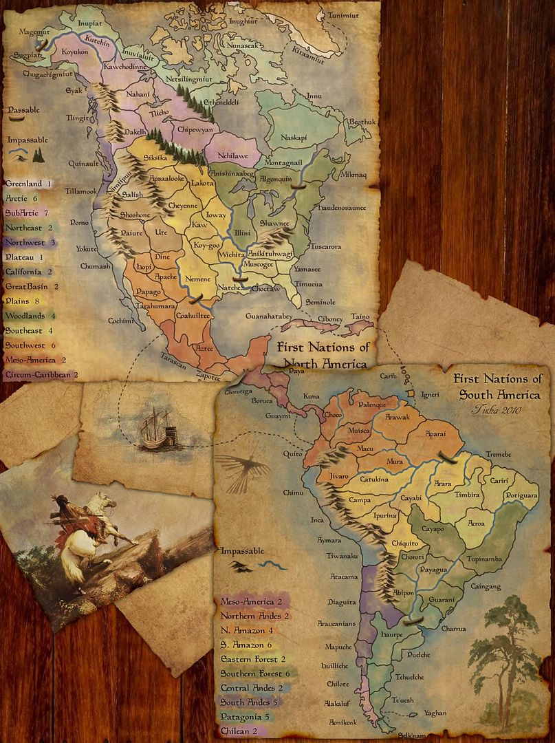
It might just be my old eyes, but in several places it's difficult to tell where an impassable river ends and a passable border begins. Is there any way to increase the contrast between the two?

Silvanus wrote:perch is a North Korean agent to infiltrate south Korean girls
-
Victor Sullivan

- Posts: 6010
- Joined: Mon Feb 08, 2010 8:17 pm
- Gender: Male
- Location: Columbus, OH
- Contact:
Re: First Nations of South America!
I'm okay with it, but it does get a tad hard to tell around Tupinamba (excuse me if it's misspelled).perchorin wrote:It might just be my old eyes, but in several places it's difficult to tell where an impassable river ends and a passable border begins. Is there any way to increase the contrast between the two?
Beckytheblondie: "Don't give us the dispatch, give us a mustache ride."
Scaling back on my CC involvement...
Scaling back on my CC involvement...
-
jwithington

- Posts: 378
- Joined: Sat Aug 04, 2007 3:56 pm
- Gender: Male
- Location: Portland, OR
- Contact:
Re: First Nations of South America!
I agree--I keep misplacing armies because the borders around Payagua/Charrua are unclear.perchorin wrote:It might just be my old eyes, but in several places it's difficult to tell where an impassable river ends and a passable border begins. Is there any way to increase the contrast between the two?
Winner: Lurk's Roulette
Played on the Portland Trailblazers in the NBA 2010 Playoffs
Played as Northwestern in 2008-09, 2009-10, and 2010-11 College Hoops Tourneys.
Semifinalist: CCC Masters: Division 2.
Played on the Portland Trailblazers in the NBA 2010 Playoffs
Played as Northwestern in 2008-09, 2009-10, and 2010-11 College Hoops Tourneys.
Semifinalist: CCC Masters: Division 2.
-
Risky_Stud
- Posts: 297
- Joined: Sun Dec 24, 2006 12:04 am
- Gender: Male
- Location: Recliner Surfing in my living room

Re: First Nations of South America!
Well obviously some people do. Not everyone's eyes see things the same way and I'm telling you it's very unclear in places.Risky_Stud wrote:Blue is water, black is border.
Don't see a problem here guy's.
Silvanus wrote:perch is a North Korean agent to infiltrate south Korean girls
-
The Bison King
- Posts: 1957
- Joined: Thu Aug 27, 2009 5:06 pm
- Location: the Mid-Westeros
Re: First Nations of South America!
I am having no problem distinguishing borders from impassable.

Re: First Nations of South America.. small version: page 17
This looks amazing. The background is perfect.Tisha wrote:I have a ton of shut up's in me, you just haven't been around me enough (:the.killing.44 wrote:lol, where did that come from.
time for larger maps now:
- Click image to enlarge.
Quench now please, thanks!
Yes, I realise it's too wide for the site at the moment.
-
The Bison King
- Posts: 1957
- Joined: Thu Aug 27, 2009 5:06 pm
- Location: the Mid-Westeros
Re: First Nations of South America.. small version: page 17
icehack wrote:This looks amazing. The background is perfect.Tisha wrote:I have a ton of shut up's in me, you just haven't been around me enough (:the.killing.44 wrote:lol, where did that come from.
time for larger maps now:
- Click image to enlarge.
Quench now please, thanks!
Yes, I realise it's too wide for the site at the moment.
-
Victor Sullivan
- Posts: 6010
- Joined: Mon Feb 08, 2010 8:17 pm
- Gender: Male
- Location: Columbus, OH
- Contact:
Re: First Nations of South America.. small version: page 17
I agree! Though there are two Meso-Americas...The Bison King wrote:This would be the most kick ass map imaginable
More on topic: Maybe it's just me, but if you look at the southern portion, if you manage to get Patagonia, South Andes, and Chilean, that's a rock solid 12 troops for a mere 4 borders. I mean, I can understand why the bonuses are what they are, but this seems a tad absurd. This has happened to me once in game and they easily swept the board once they got that southern third. I'll see if that happens in more games I play, but it's just a concern of mine. Nice work, Tish.
Beckytheblondie: "Don't give us the dispatch, give us a mustache ride."
Scaling back on my CC involvement...
Scaling back on my CC involvement...
-
ScavengerType

- Posts: 41
- Joined: Thu Apr 16, 2009 10:01 pm
- Gender: Male
- Location: BC
Re: First Nations of South America!
that would be an crazy map.
However I think everyone is wrong about the bonuses being a problem. In actuality this map is ridiculously like the NA map in it's architecture A lot of the mass in the greater Brazilian area is nearly totally undefendable (too many borders). In actuality the winner is almost always going to be someone who fights to gain the northern or southern tip. That is assuming a non escalating game. Don't forget that the bonus for taking the greater arctic area (including north east) in the North America map you can get a bonus of 16 on 4 borders. It's not as easy perhaps as in this map but nor is the bonus so great here.
However I think everyone is wrong about the bonuses being a problem. In actuality this map is ridiculously like the NA map in it's architecture A lot of the mass in the greater Brazilian area is nearly totally undefendable (too many borders). In actuality the winner is almost always going to be someone who fights to gain the northern or southern tip. That is assuming a non escalating game. Don't forget that the bonus for taking the greater arctic area (including north east) in the North America map you can get a bonus of 16 on 4 borders. It's not as easy perhaps as in this map but nor is the bonus so great here.

Re: First Nations of South America!
- Quenching
Congratulations Tisha, your shiny new medal is well-earned
Conquer Club, enjoy!


PB: 2661 | He's blue... If he were green he would die | No mod would be stupid enough to do that
-
rdsrds2120

- Posts: 6274
- Joined: Fri Jul 03, 2009 3:42 am
- Gender: Male
Re: First Nations of South America!
'Bout time this twas released! Congrats! I love it (:
-
Victor Sullivan
- Posts: 6010
- Joined: Mon Feb 08, 2010 8:17 pm
- Gender: Male
- Location: Columbus, OH
- Contact:
Re: First Nations of South America!
Beckytheblondie: "Don't give us the dispatch, give us a mustache ride."
Scaling back on my CC involvement...
Scaling back on my CC involvement...
Re: First Nations of South America!
Wow, out of beta and I haven't played this map yet. Where was I? Still, I enjoy the North American map and I look forward to playing this one.